U.S. Department of Transportation
Federal Highway Administration
1200 New Jersey Avenue, SE
Washington, DC 20590
202-366-4000
Traffic monitoring within a State DOT affects many other functions and offices, and it is important for traffic monitoring staff to be aware of how their work and the data it produces affects the business of their customers and partners. Additionally, the audience for this Guide should be aware of how the work of their customers and partners affects their processes and work. The most important theme of this chapter is the need for coordination and cooperation among those groups responsible for traffic monitoring functions and the processes affected by them. This is especially important in light of the passage of MAP-21 and its emphasis on performance measures.
This chapter covers guidance and examples related to coordinating activities with transportation management and operations functions within State DOTs. The specific types of functions covered here include:
Most of the chapter is dedicated to coordination with the traffic management and operations functions covered in Section 5.2. Sections 5.3 through 5.6 are designed to inform traffic monitoring staff about the other functions listed above and to suggest coordination mechanisms
Traffic monitoring functions in many State DOTs are managed within two different workgroups, as follows.
1. Planning and Programming – this group collects, maintains, and reports historical traffic statistics for agency planning, programming, and public information. This group is the primary audience for this Guide. The discussion of data collected in the planning and programming group is distributed throughout the TMG.
2.Traffic Management and Operations – this group collects real-time traffic condition data to manage and operate the State highway network. This is often accomplished within transportation management centers (TMCs) where the flow of data and traveler information is managed.
Because these two groups are often organized into separate agency divisions or offices, they typically function independently of one another with their own separate budgets and traffic monitoring equipment and infrastructure. In some cases, these two groups may have traffic monitoring sensors placed immediately adjacent to one another, which operate and report independently.
Several State DOTs have begun developing cooperative approaches to traffic monitoring between their planning and operations groups. These DOTs are coordinating functions such as installing new equipment, sharing data from existing equipment, and sharing costs and responsibilities for installation and maintenance. In a time of severely constrained budgets, traffic monitoring resource coordination and sharing simply makes sense.
There can be significant cost savings associated with resource sharing. This section begins by outlining the typical data requirements for traffic management and operations, and compares and contrasts these requirements to typical planning-based data requirements. The section also provides several different examples to illustrate various possibilities for resource sharing. Appendix D and Case Studies 3 and 4 also describe approaches used for data sharing.
The first step in coordinating traffic monitoring activities between planning and operations-based workgroups is to understand the functions within each workgroup that have similar data requirements. These similar data requirements represent immediate opportunities for coordination and can be used to build the foundation for further cooperation.
Providing detailed data requirements for all possible traffic management functions is beyond the scope of this chapter. Instead, several attributes of typical operations-based traffic monitoring systems and functions are outlined. This outline should help to better define the common areas of interest as well as potential obstacles to overcome.
Although the specific details and capabilities are evolving, two basic types of operations-based traffic monitoring systems are relevant to this discussion:
1. Fixed-point sensor systems that measure the attributes of all detected vehicles passing a permanent equipment location. Inductive loop detectors are the most common fixed-point sensor, but other non-intrusive sensor technologies (e.g., radar, video, magnetometer, etc.) are increasingly being used
2. Probe-based systems that monitor a sample of specially instrumented vehicles as they routinely traverse the road network. Probe-based systems can monitor vehicle travel at fixed locations (typically called re-identification, such as toll tag or Bluetooth matching), at predetermined time intervals using wireless communications (GPS or cell phone-based probes), or a combination.
Probe-based systems can collect a variety of data attributes, but the most common attributes for traffic management functions are spot speed and/or link travel time. With re-identification systems, unique anonymous vehicle identifiers can be matched to provide origin-destination data. The probe-based system only monitors a sample of specially instrumented vehicles; relevance to planning traffic monitoring (covering the entire populations) is limited. This is likely to change in the future, as specially instrumented vehicles become much more common or even universal in the traffic stream.
Area-based systems such as radar, video and satellite can detect multiple vehicles over an area at the same time. However, they are generally not used for traffic measurement. Fixed-point sensor systems will likely be the near-term target for cooperation and coordination between planning-based and operations-based traffic monitoring. In some cases, the exact same sensor technologies are used by both workgroups. However, several differences exist in the design of each workgroup’s monitoring system.
Focus on Real-Time, Most Current Conditions – Operations-based systems are designed with a clear focus on gathering and using the most current, up-to-date real-time travel data. After inclusion of the Archived Data User Service (ADUS) in the National ITS Architecture in the late 1990s, more operations based systems are including the capability to permanently archive/save real-time data. However, historical data retention and access remains a secondary focus and is sometimes neglected in traffic management systems.
Communications Design – Operations-based systems are designed to collect and send traffic data to a centralized database in real-time, which typically range from every 20 seconds to 2 minutes. Therefore, little traffic data is stored on field devices, and sometimes a real-time communications packet will fail. The result is small gaps of missing data across most locations and times of the day.
Location of Sensors – Some operations-based sensors are placed in the immediate vicinity of freeway entrance ramps for metering entering traffic. On arterial streets, sensors are commonly placed at intersection approaches for presence detection for traffic signal control. These locations are desirable for traffic control purposes (for measuring lane occupancy or presence), but are probably less than optimal for traffic counting purposes. However, operations-based data samples at locations like these should first be evaluated for accuracy instead of being dismissed outright.
Equipment Maintenance – For a variety of reasons, some DOTs have not been able to maintain their operations-based sensors at the level desired by planning-based workgroups. The most common workaround for this has been to designate a limited subset of the operations-based sensors for priority maintenance.
Equipment Calibration – In many TMCs, spot speed data is the most commonly used data attribute for incident detection, traveler information, and overall traffic management. Traffic counts are rarely used for traffic management functions. A consequence is that sometimes these fixed-point sensors are not adequately calibrated for accurate traffic counting (i.e., spot speeds can still be accurately measured even if the sensor does not detect all vehicles).
Several State DOTs have tried to coordinate traffic monitoring approaches between their operation and planning workgroups. Some attempts have resulted in usable traffic data for both groups, some are ongoing, and a few have failed. The successful approaches can be categorized into four basic types, based on where the stream of collected data diverges into separate data flows to the traffic operations and planning workgroups (see Figure 5-1):
1. At the traffic sensor – Some non-intrusive traffic sensors offer on-device data storage capability, which provides the ability to bin and store data for two or more separate groups.
2. At the roadside cabinet – With traffic sensors that do not have on-device data storage capability, the data flow should be split at the roadside cabinet. With some equipment vendors, a single multi-function controller or traffic data recorder can be used to collect both real-time data for operations and binned count totals once daily for planning. With legacy equipment, a separate traffic data recorder may be needed for binning, in addition to the operations-based traffic controller.
3. After the TMC – Once the traffic data has been gathered by the TMC, it can be archived in its original from-the-field format (such as 20-second periods), or it can be post-processed and summarized into aggregate data (such as 5-, 15-, or 60-minute time periods). Chapter 7 of the AASHTO Guidelines for Traffic Data Programs contains detailed information on best practices to integrate operations data after it has been archived.
4. Coordinated equipment location only – This approach has been used when the traffic operations and planning workgroups cannot agree on a common traffic sensor specification. By selecting mutually agreeable equipment locations for traffic monitoring, the two groups, though using disparate technologies, can share/save on construction mobilization, power, and communications costs. In this approach, the roadside equipment cabinets may or may not be shared, depending upon each group’s needs and requirements.
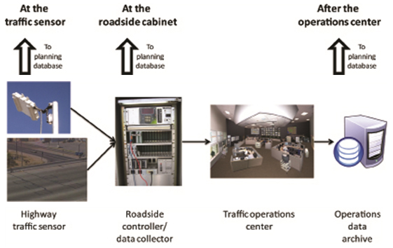
Source: Federal Highway Administration.
When developed in 1999, the Archived Data User Service envisioned that real-time data would be sent to a historical archive (approach #3), which would then be the single entry point for all archived data users. In practice, however, several DOTs have found it more advantageous to capture traffic data for planning purposes earlier in the data stream (approaches #1 and #2). The following examples illustrate a variety of ways in which resources can be better coordinated for traffic monitoring purposes.
Illinois DOT planners have been using operations-based data for several years and have relied on a data archive (i.e., “After the operations center” in Figure 5-1) as their primary means to obtain the data
The Illinois Traffic System Center (TSC) monitors nearly 150 freeway miles with 2,400 detectors. Transportation planners at the Illinois DOT and the Chicago Area Transportation Study (CATS) have used the TSC’s archived data for several years. The access mechanism and data formats have evolved several times since data sharing began. In 2004, a private company began collecting operations traffic data from its roadway sensors in the Chicago area as part of the FHWA’s Intelligent Transportation Infrastructure Program (ITIP). A provision of the ITIP contract requires the private company to integrate the public agency traffic data (in this case, Illinois DOT) with their own data and provide the combined archived data for planning purposes.
The Illinois DOT’s Office of Planning and Programming has designated 35 operations-based detector locations as continuous count stations. These 35 locations were selected based on spacing and the availability of detectors in all lanes. The Illinois DOT planners download hourly traffic data in MS Excel format on a monthly basis from the private company’s web site. The hourly traffic counts are imported into IDOT’s planning database, where they undergo standard data quality review checks. Valid data is then made available for summarization and reporting. Once integrated within the planners’ traffic database, the archived operations data is used for HPMS reporting as well as other AADT count reports.
Before the current system was in place, IDOT planners struggled with efficient data access and formatting issues. Early efforts at using IDOT TSC archived data for planning relied on paper copies of summarized data. In the 1980s and 1990s, CATS used the TSC archived data to produce a Travel Atlas that reported AADT values for the Northeastern Illinois Expressway System. IDOT planners have noted few problems with the current system for accessing archived operations data, and data quality has been acceptable due to responsive operations equipment maintenance procedures.
The most important lessons learned are as follows:
Minnesota DOT planners have been using operations-based data for several years and have contracted with the University of Minnesota-Duluth to develop software that automates the process (using the “After the operations center” approach shown in Figure 5-1).
MnDOT’s Regional Transportation Management Center (RTMC) monitors more than 500 freeway miles and maintains about 5,000 inductive loop detectors (including both mainline and ramp-based detectors) in the Minneapolis-St. Paul area. The University of Minnesota-Duluth has developed post-processing software that reviews the quality of the data, imputes missing data, and summarizes the archived operations data to planning-level traffic statistics for the planning division.
The MnDOT RTMC has made the archived operations data publicly available since the late 1990s and provides numerous data extraction and analysis tools. Both MnDOT operations and planning staff use the archived operations data for a variety of other applications and purposes. Detector maintenance has been a priority for MnDOT because the inductive loop detectors are essential for several key traffic management functions (like ramp metering). Typically, the detectors are operating at higher than 95% availability.
The most important lessons learned are as follows:
Ohio DOT planners have been working with their traffic operations group to obtain operations-based data from several different data archives (i.e., “After the operations center” in Figure 5-1).
The Advanced Regional Traffic Interactive Management and Information System (ARTIMIS) in Cincinnati monitors more than 50 miles of freeway using 1,100 traffic detectors of various types. Ohio DOT planners selected several ARTIMIS detector locations to serve as continuous count stations. They were able to download the archived hourly traffic count files from an ARTIMIS computer server. The archived data were imported into the planning database as raw hourly counts, which were then processed by the data quality review checks. Valid data was then retained for summarization and reporting purposes, including HPMS reports and official AADT count reports. It was noted that there were some data quality issues with the archived operations data.
In addition to ARTIMIS in Cincinnati, recently developed traffic management software is used (and provides archived operations data) in Akron-Canton, Cleveland, and Columbus. The Ohio DOT planners provided input on a preferred data format for the archived data files that closely resembles those specified in the Traffic Monitoring Guide. The Ohio DOT planning group also cooperated with the operations group in specifying field computers that are capable of collecting vehicle classification data.
Similar to Illinois DOT, the Ohio DOT also uses ITIP operations-based data that has been collected and archived by a private data provider. This ITIP data is being collected at selected locations in Cincinnati and Columbus.
The most important lessons learned are as follows:
Utah DOT planners first attempted to use the archived ITS data directly from the traffic operations center (i.e., “After the operations center” in Figure 5-1), but had the common problem of periodic missing/incomplete data. After several attempts, the planning group decided to install their own data collection units at selected operations-based locations (i.e., “At the roadside cabinet” in Figure 5-1). Recently, they have also begun using ramp traffic counts from an operations data archive that was provided via FHWA’s ITIP program.
Utah DOT planners are getting data from operations-maintained sensors. The planning group is using the operations-based cabinets and installing their own data collection equipment alongside the operations equipment. The equipment enables the signal from the traffic sensors to be split; the operations-based controller reports data in frequent time intervals (less than 5 minutes), whereas the planning-based equipment reports data on a daily basis.
Newer non-intrusive sensors have also been installed by the Utah DOT operations staff, and these sensors permit multiple outputs at the traffic sensor itself (i.e., “At the traffic sensor” in Figure 5-1).
UDOT planners are also now getting ramp counts at about 50 locations from an archived ITS system called PeMS, which is similar software to what California is using. The Utah PeMS was installed as part of FHWA’s ITIP program. There is still some missing data in these ramp counts, but UDOT planners are able to use this data in their traffic monitoring system. Finally, the UDOT planning group does once-a-year spot checks at shared continuous locations to ensure that accurate data is being collected.
The most important lessons learned are as follows:
Virginia DOT (VDOT) has taken an innovative and unique approach to resource sharing with regard to traffic monitoring. In Virginia, the Traffic Engineering Division (TED) is responsible for traditional traffic monitoring program activities. TED worked closely with the Operations and Security Division (OSD) (which operates the traffic operations centers) with the installation of planning-based sensors in less urbanized regions of the State. A major factor in the success of the program is that both TED and OSD fall under the same organization within VDOT.
The VDOT approach has two components, depending upon the types of traffic sensors installed:
1. For existing inductive loop detectors, an existing commercial product is used to provide real-time data to traffic managers in OSD and daily data uploads to TED, with both data flows coming from the same equipment. This is analogous to “At the roadside cabinet” as shown in Figure 5-1.
2. For new installations of non-intrusive traffic sensors, separate data flows to both OSD and TED are available from the traffic sensor itself (i.e., “At the traffic sensor” in Figure 5-1).
The TED had additional funding for equipment to meet the data requirements for performance measures, and this was the mechanism used to install the newer non-intrusive sensors.
The most important lessons learned are as follows:
Sudden shifts in the movement of traffic because of evacuations (planned or not planned), emergencies, or planned events have a significant impact on the operation of the transportation system. Emergency operations centers (EOCs) are often established during times of need such as weather events (hurricanes, etc.), homeland security breaches, and other unexpected emergency events. These EOCs are often collectors and users of traffic speed and volume data to carry out their functions.
There are functions within State departments (other than the DOTs) responsible for planning for large-scale events. These functions are usually associated with tourist or economic offices. Oftentimes, State traffic operations offices are notified and included in the planning of special events that may impact traffic operations and monitoring, and in the operation of EOCs. However, traffic monitoring functions within planning offices are not always included in these activities. However, having a good baseline of the traffic can only benefit in planning transportation management plans for special events.
The FHWA Managing Travel for Planned Special Events Handbook: Executive Summary strongly encourages the use of traffic monitoring on the day of the event. Traffic monitoring is one of several day-of-event activities necessary to ensure a successful event and more importantly, future events. Real time traffic monitoring allows for a “swift and coordinated response to unplanned events.”
The Executive Summary provides a clear explanation of why traffic monitoring is an important day-of-event activity. It provides traffic and incident management support in addition to performance evaluation data. Timely deployment of contingency plans developed during the event operations planning phase depends on the accurate collection and communication of real-time traffic data between traffic management team members. Potential uses of day-of-event traffic/conditions monitoring observations and information include:
Methods for collecting traffic data on the day-of-event include: 1) CCTV systems for viewing real-time conditions; 2) in-roadway or over-roadway traffic sensors; 3) vehicle probes for surveillance and travel data; 4) traffic signal and system detectors; 5) parking management systems; and 6) manual methods. Example statistics or measures that can be obtained from traffic monitoring on the day-of-event include congestion delay, travel time, travel speed, change in travel mode, and change in transit ridership
The FHWA Planned Special Events: Checklists for Practitioners includes traffic monitoring as one of its checklists
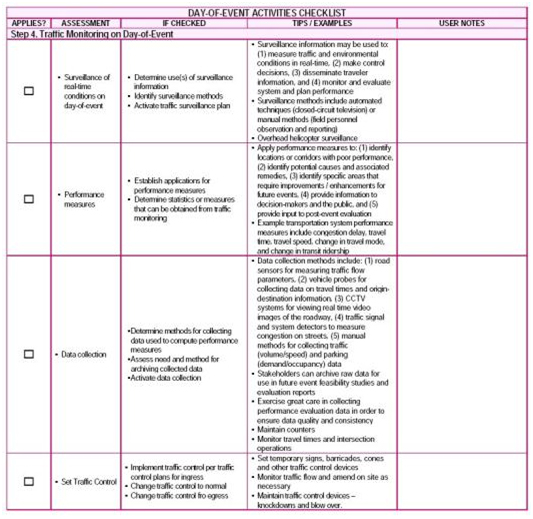
Source: FHWA – HOP – 06-113, Planned Special Events: Checklists for Practitioners.
FHWA’s iFlorida Model Deployment Final Evaluation Report (January 2009) found that prior to iFlorida, access to real-time traffic data to support evaluation decision making was limited. On a statewide level, Florida Department of Transportation (FDOT) supported a network of 54 monitoring stations that uploaded hourly data and made that data available via the internet during a hurricane evacuation. Staff at the State Emergency Operations Center (SEOC) monitored this information and, when observed volumes significantly exceeded historical values, alerted evacuation managers at the SEOC. The Florida Highway Patrol also reported on congestion observed by its personnel in the field. Individual counties would sometimes report on traffic problems during regularly scheduled conference calls between the SEOC and all FDOT counties.
Georgia Department of Transportation (GDOT) uses the data it collects for both leisure purposes and evacuations. The GDOT Office of Transportation Data provides data to a large variety of external customers, including transportation planning professionals, educational institutions, design engineers, contractors, real estate agencies, private companies, and other government agencies. Traffic data is important in determining which routes citizens are using for their daily commutes and leisure travel. In addition, during emergency evacuations, critical traffic data is provided to the Georgia Emergency Management Agency and surrounding states. The data is used on a state and national level by the U.S. DOT and other customers for planning, modeling, allocating of funding, etc. (Georgia Department of Transportation Traffic Monitoring Program V2, 2012.)
South Carolina has also incorporated traffic monitoring data into its evacuation plans. According to the Dorchester County Government website, emergency planners have significantly improved evacuation plans. Since Hurricane Floyd, the state has established lane-reversal strategies on some major highway such as Interstate 26, expanded traffic monitoring systems, and improved coordination of multi-state evacuation plans.
Traffic monitoring staff should proactively reach out to emergency operators and planners of special events on a routine basis. A collaboration mechanism should be established and coordination maintained to discuss issues such as data formats available and needed for sharing. They should make the traffic and speed data available to them for their use. A good example of this is in Florida, where the permanent traffic counters can be polled in real time to monitor the flow and speed of traffic along evacuation routes. The polling is activated during emergencies such as hurricane evacuation, and the real time data (updated every 5 minutes) is made available on a map on the Internet for the public and EOC use.
Occasionally, traffic monitoring staff may also obtain additional funding or sources of additional data to supplement their programs.
Commercial vehicle enforcement is an important function within a State DOT to ensure that overweight vehicles do not damage pavement and shorten the life of transportation facilities. The commercial vehicle operations (CVO) office may be located within operations, planning, or maintenance. However, it may fall outside the jurisdiction of the DOT altogether (e.g., Department of Public Safety). The CVO office often installs and maintains weigh in motion (WIM) equipment at designated locations (notably at weigh stations). The CVO is responsible for enforcing maximum weight limits for commercial vehicles. The CVO office is also often involved with planning for freight traffic and efficient operations within the State.
The traffic monitoring office should coordinate with the CVO office regularly regarding:
1. Shared use and maintenance of WIM equipment – Both groups could benefit from potential resource sharing.
2. Shared use of data – The CVO office can benefit from real time WIM data to detect overweight vehicles for purposes of enforcement. In addition, the CVO office could benefit from the traffic data generated by the traffic monitoring office for purposes of planning longer-term operations or enforcement activities. For example, traffic data should be made available to the CVO or department responsible for weight enforcement on a regular basis to assist in their targeted enforcement planning activities.
National and State safety programs are dependent upon accurate, timely and complete data to support reporting, analysis of countermeasures, decision-making and resource allocation for safety improvement. The Highway Safety Improvement Program (HSIP) relies on both crash and roadway data elements to support safety analysis and planning
The safety community at Federal and State levels could benefit from working with their partners in the planning and operations offices of the State DOTs to ensure that the needed data is collected once and used many times, so that resources can be integrated and economies of scale achieved. Recent Federal initiatives have emphasized the need for integration of roadway, crash, and traffic data even more in support of highway safety programs.
Safety functions are generally conducted within a State DOT, either within the operations office, a separate safety office, or planning offices. Example functions include production of statistical reports and performance measures related to fatalities and vehicle miles traveled (VMT) and analysis of high crash locations based on crashes and VMT.
Traffic monitoring staff should make a concerted effort to ensure that the safety offices are aware of the data collection and reporting capabilities in the traffic monitoring offices. They should learn how their safety partners are using VMT data and any other traffic data collected by the traffic monitoring group, and what other initiatives are ongoing in the safety offices that may be of interest to the traffic monitoring office. There may be opportunities for shared resources for locating traffic monitoring devices and for exchange of data and information collected by those devices. For example, there may be an opportunity to share resources to collect traffic data on non-state highway facilities because safety offices are required to report on crashes and VMT for all public roads.
The traffic monitoring group is often located in the transportation planning group within a State DOT. However, they may not always be aware of the opportunities for collaboration with the transportation planners related to data collection and analysis. The planning division is responsible for long and short range multi-modal transportation planning, which often involves the use of micro and macro travel demand models. The models often require detailed traffic volume and speed data as input to the models. This data is then used to produce travel forecasts, or projections of future travel, on a route or within a particular corridor. Planning staff are exploring new passive methods of data collection including private sector sources. Other planning functions that require traffic and speed data include access management, corridor planning, project prioritization, and programming of funding streams
The traffic monitoring community should coordinate carefully with transportation planners to ensure they are aware of the vast data resources (including real time data) available for modeling and analysis. If the planning group is investigating newer data sources, the traffic monitoring community could benefit by integrating the new data with existing data.
For example, many offices within a State DOT are currently interested in obtaining private sector probe/GPS data for the purposes of speed and origin/destination data. These offices include operations, planning, and freight for the purposes of modeling, long-range planning, and performance reporting.
The traffic monitoring office should continue to partner with metropolitan planning organizations (MPOs) and Councils of Government (COGs) for exchange of traffic data used for modeling and analysis, particularly in urbanized areas or areas designated as non-attainment status according to the Environmental Protection Agency (EPA) standards.
This chapter discussed the importance of establishing regular collaboration and communication between traffic monitoring professionals and many other State DOT and local government offices. Some mechanisms for establishing and maintaining such coordination are described below.
The first step should be to identify contacts in the relevant offices. Consider contacting the office manager for the relevant department/section to express the desire to coordinate. It may be appropriate to send the representative a copy of this chapter of the TMG. A discussion could follow to cover the following items/questions:
These questions could start a conversation related to how the two offices could better share information, data, and possibly resources to achieve their individual mission.
Another successful strategy may be to establish a data coordination group. The group could be comprised of representatives from all of the offices mentioned in this chapter (operations, emergency, planned/special event planning, freight, commercial vehicle enforcement, safety, and planning). The group could meet on a regular basis to discuss what data is collected and how gaps or overlaps in collection could be resolved.
The end result of initiating and establishing regular communication mechanisms between traffic monitoring and other offices will be maximization of the use of limited resources for collecting, analyzing, and reporting traffic data.

