U.S. Department of Transportation
Federal Highway Administration
1200 New Jersey Avenue, SE
Washington, DC 20590
202-366-4000
2020 travel origin destination (OD) data from FHWA’s National Household Travel Survey (NHTS) is now available. These data will be used to facilitate the assessment of future travel demands and the establishment of transportation improvement programs at Federal, state, and local level transportation agencies. The NHTS program collects and analyzes a set of core data related to multimodal travel behavior information through periodic household surveys. Data items such as how many trips on average a person makes in a day by what mode (e.g., air, rail, vehicle, walking) and for what purpose (e.g., work, shopping, medical appointment) are derived from this analysis. Such traveler behavior information informs national, state, and local transportation legislation, policy, and program development and deployment.
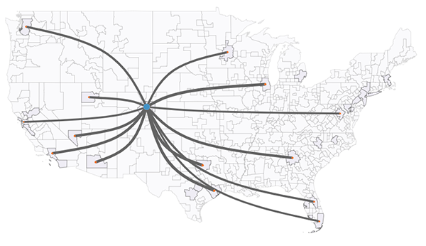
Top 14 air passenger origins destinated to the Denver metropolitan zone.
Source: FHWA
While FHWA's NextGen NHTS continues its focus on the core data, its coverage is expanded to the travel origin destination (OD) data. The OD data set provides information about the number of trips people make from place to place. It supplies quantitative information on the number of trips people make between interzonal trips (between zones) and intrazonal trips (within a single zone). This data helps identify local, regional, and national travel corridors; bottlenecks and challenges; and multimodal transportation solutions.
The calendar year 2020 OD data —released at https://nhts.ornl.gov/ offers interzonal and intrazonal travel information. It covers all modes of travel such as air, rail, vehicle, and active transportation (walking and the use of bicycles, scooters, e-bike, e-scooters, hoverboards, small ferries, etc.). 583 zones have been developed based on the hybrid boundaries using the 2010 Metropolitan Statistical Areas and 2010 Micropolitan Statistical Areas, FHWA Freight Analysis Framework zonal definitions, and a State's zonal geographical continuity consideration.
In 2020, the U.S. saw more than 314 billion total person-trips across 583 measurement zones. 93 percent of person-trips were intrazonal, while only 7 percent were interzonal. More than 87 percent of all person-trips used vehicles, and more than 12 percent used “active transportation” — such as walking and bicycling. Air and rail travel accounted for less than 2 percent of all person-trips that year. Along with the 2020 data release, methods used to generate the data and a set of online analytical tools are shared, allowing data exploration and utilization. FHWA will continue improving data methods and quality as it develops future OD data. For more information on the NHTS, please visit the FHWA NHTS website.
If you have any suggestions or questions, don't hesitate to contact FHWA at PolicyInfoFeedback@dot.gov by using the text “NextGen NHTS” in the subject line.