All TNM Validation Phase 1 measurement sites are described here in detail, including site location, microphone positions, and meteorological system positions. This information has been reproduced from Rochat (2002). All heights of the instrumentation are measured above the ground level, with exceptions noted. In addition to a photograph of each site, the TNM plan and skew views for the model of each site are presented. The following abbreviations are applied in the site descriptions:
| DGAC | Dense-graded asphalt concrete |
|---|---|
| OGAC | Open-graded asphalt concrete |
| PCC | Portland cement concrete |
| d | Distance from roadway |
| bb | Distance behind barrier |
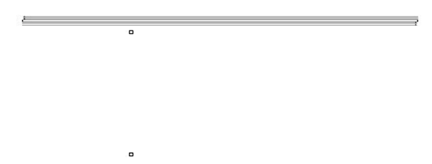
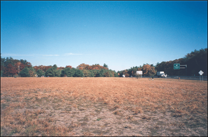
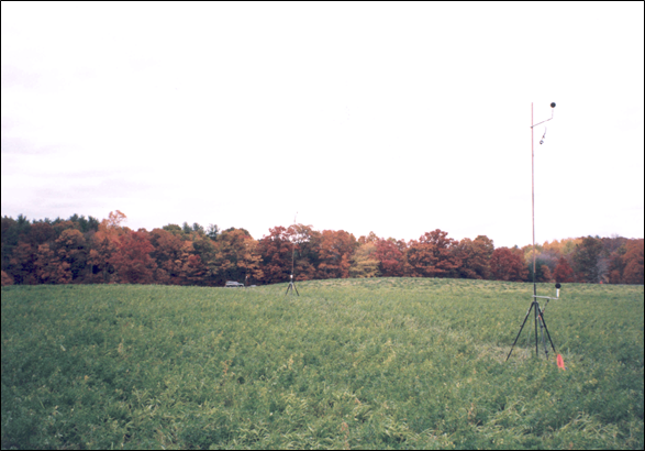
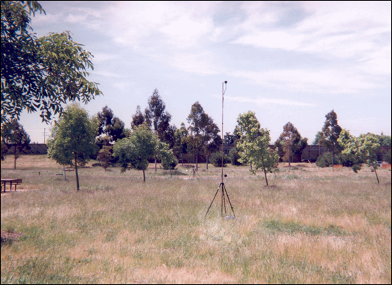
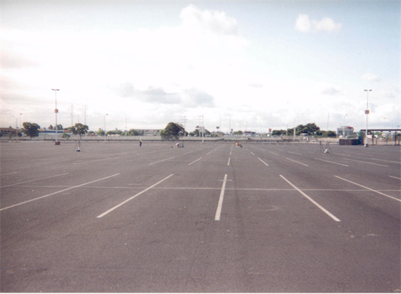
| Site ID | 01MA | |
|---|---|---|
| Location | Taunton, MA; Route 24; Southbound side; just North of Exit 12, near overpass | |
| Site Type | open area, flat | |
| Ground Type | field grass, acoustically soft | |
| Roadway | 4 lanes, DGAC, shoulders, field grass median | |
| Instrumentation Positions | Microphones d = 50 ft, height = 5 and 15 ft d = 100 ft, height = 5 and 15 ft d = 200 ft, height = 5 and 15 ft |
Meteorological Systems d = 75 ft, height = 5 and 15 ft d = 150 ft, height = 5 and 15 ft |
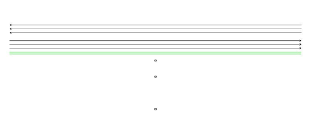
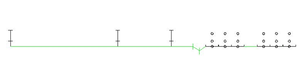
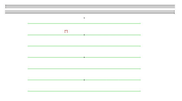
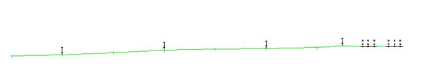
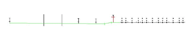
| Site ID | 01MA - TNM model |
|---|---|
| Default Ground Type | field grass |
| Pavement Type | average |
| TNM objects | roadways, receivers, terrain lines (defining trench: depth = 4 ft) |
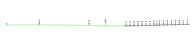
| Site ID | 02MA - TNM model |
|---|---|
| Default Ground Type | field grass |
| Pavement Type | average |
| TNM objects | roadways, receivers, terrain lines (defining undulations: ranging from -20 to +3 ft), barrier (for large boulder) |
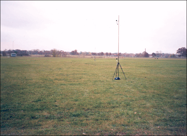
| Site ID | 03MA | |
|---|---|---|
| Location | Springfield, MA; Route 291; Northbound side; South of Exit 5; Smith & Wesson soccer fields | |
| Site Type | open area, flat | |
| Ground Type | lawn, acoustically soft | |
| Roadway | 4 lanes, DGAC, shoulders, hard soil median | |
| Instrumentation Positions | Microphones d = 50 ft, height = 5 ft above roadway level d = 200 ft, height = 5 and 15 ft d = 400 ft, height = 5 and 15 ft d = 800 ft, height = 5 and 15 ft |
Meteorological Systems d = 150 ft, height = 5 and 15 ft d = 600 ft, height = 5 and 15 ft |
| Site ID | 03MA - TNM model |
|---|---|
| Default Ground Type | lawn |
| Pavement Type | average |
| TNM objects | roadways, receivers, ground zone (hard soil median: width = 14 ft) |


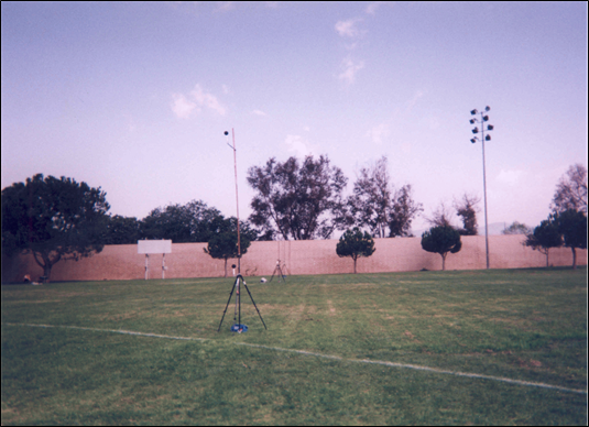
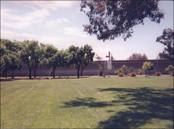
| Site ID | 05CA | |
|---|---|---|
| Location | Chino Hills, CA; Route 71; Southbound side; just North of Central Ave/Soquel Cyn Pkwy Exit; near intersection of Los Serranos and Pomona Ricon | |
| Site Type | barrier (15 ft concrete block), flat | |
| Ground Type | field grass, acoustically soft | |
| Roadway | 8 lanes, PCC, shoulders, pavement median | |
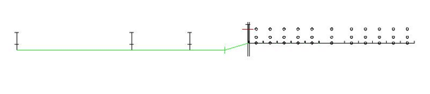
| Instrumentation Positions | Microphones bb = 0 ft, height = 3.5 ft above barrier bb = 50 ft, height = 5 and 15 ft bb = 100 ft, height = 5 and 15 ft bb = 150 ft, height = 5 and 15 ft |
Meteorological Systems bb = 75 ft, height = 5 and 15 ft bb = 125 ft, height = 5 and 15 ft |
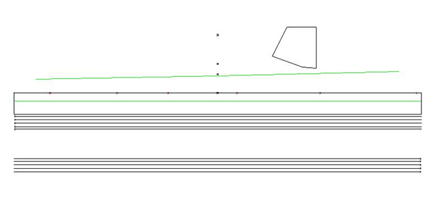
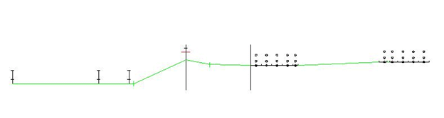
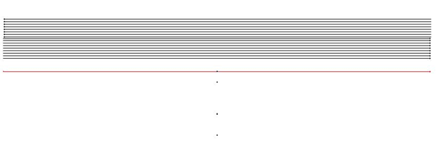
| Site ID | 05CA - TNM model |
|---|---|
| Default Ground Type | field grass |
| Pavement Type | average |
| TNM objects | barrier, roadways, receivers |
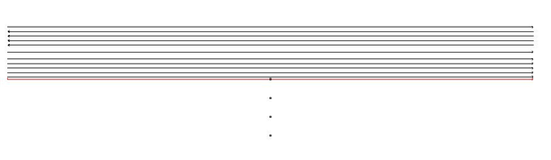
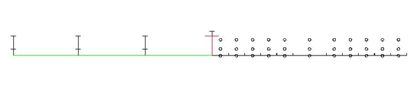
Figure A.5 - B: Site 05CA TNM Model Description, TNM Plan and Skew Views
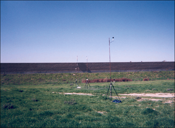
| Site ID | 06CA | |
|---|---|---|
| Location | Wildomar, CA; Route 15; Southbound side; South of Baxter Exit; playing fields of Donald Graham Elementary School | |
| Site Type | barrier (ave 12.5 ft: 5 ft berm, 7.5 ft concrete block wall), flat, with 27 ft drop-off from barrier | |
| Ground Type | lawn, acoustically soft | |
| Roadway | 6 lanes, DGAC, shoulders, grass median | |
| Instrumentation Positions | Microphones bb = 0 ft, height = 5 ft above barrier bb = 55 ft, height = 5 and 15 ft bb = 100 ft, height = 5 and 15 ft bb = 200 ft, height = 5 and 15 ft |
Meteorological Systems bb = 75 ft, height = 5 and 15 ft bb = 150 ft, height = 5 and 15 ft |
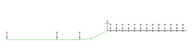
| Site ID | 06CA - TNM model |
|---|---|
| Default Ground Type | lawn |
| Pavement Type | average |
| TNM objects | roadways, receivers, barrier, terrain lines (start of change in elevation of +5 ft from roadway level to barrier base; change in elevation of -27 ft from barrier base to mic line), ground zones (hard soil for edge of road: width = 74 ft; pavement for blacktop play area: largest dimension ~ 145 ft) |
| Site ID | 08CA Measured two microphone lines: one with a single barrier (as shown and described here) and one with parallel barriers (will be analyzed in a later phase of the study) |
|
|---|---|---|
| Location | Anaheim, CA; Route 91; Eastbound side; East of Lakeview Exit; playing fields of Peralta Canyon Park | |
| Site Type | barrier (14.5 ft concrete block), relatively flat | |
| Ground Type | lawn, acoustically soft | |
| Roadway | 14 lanes, PCC (HOV lanes DGAC), shoulders, pavement median | |
| Instrumentation Positions | Microphones bb = 0 ft, height = 5 ft above barrier bb = 50 ft, height = 5 and 15 ft bb = 200 ft, height = 5 and 15 ft bb = 300 ft, height = 5 ft |
Meteorological Systems bb = 100 ft, height = 5 and 15 ft |
| Site ID | 08CA - TNM model |
|---|---|
| Default Ground Type | lawn |
| Pavement Type | average |
| TNM objects* | roadways, receivers, barrier |
*Since there is a slight incline from the 50-ft mic to the 300-ft mic, this was accounted for in the mic line using the z coordinate of the receivers (potentially important to the sound propagation path length). This incline is not consistent throughout the site and was therefore not modeled elsewhere.
| Site ID | 09CA | |
|---|---|---|
| Location | Chino, CA; Route 71; Northbound side; North of Edison/Grand Exit; field at end of Alicia St | |
| Site Type | barrier (15 ft concrete block), flat, with 16 ft drop-off from barrier | |
| Ground Type | field grass, acoustically soft | |
| Roadway | 10 lanes, PCC, shoulders, pavement median | |
| Instrumentation Positions | Microphones bb = 0 ft, height = 5 ft above barrier bb = 55 ft, height = 5 and 15 ft bb = 100 ft, height = 5 and 15 ft bb = 200 ft, height = 5 and 15 ft |
Meteorological Systems bb = 75 ft, height = 5 and 15 ft bb = 150 ft, height = 5 and 15 ft |
| Site ID | 09CA - TNM model |
|---|---|
| Default Ground Type | field grass |
| Pavement Type | average |
| TNM objects | roadways, receivers, barrier, terrain line (change in elevation of -16 ft from barrier base to mic line) |
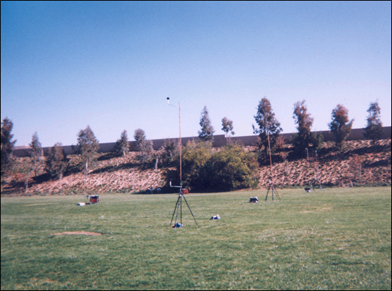
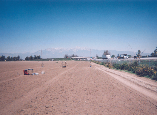
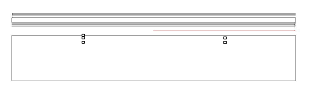
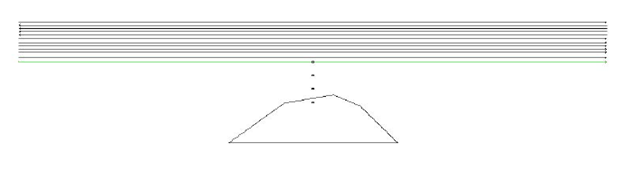
| Site ID | 10CA – berm Measured two microphone lines: one with a berm (as shown and described here) and one with an open area (shown next). |
|
|---|---|---|
| Location | Mira Loma, CA; Route 15; Southbound side; North of Limonite Ave Exit; field just North of Swan Lake Community | |
| Site Type | barrier (16 ft grass-covered earth berm), flat | |
| Ground Type | plowed dirt, acoustically soft | |
| Roadway | 6 lanes, PCC, shoulders, hard soil median | |
| Instrumentation Positions | Microphones d = 98 ft (bb = 50 ft) (in the open area mic line), height = 5 ft bb = 70 ft, height = 5 and 15 ft bb = 110 ft, height = 5 and 15 ft |
Meteorological Systems bb = 90 ft, height = 5 and 15 ft |
| Site ID | 10CA - berm - TNM model |
|---|---|
| Default Ground Type | field grass |
| Pavement Type | average |
| TNM objects | roadways, receivers, barrier (as berm), ground zones (hard soil for median: width = 48 ft; loose soil for measurement field: width ~ 450 ft) |
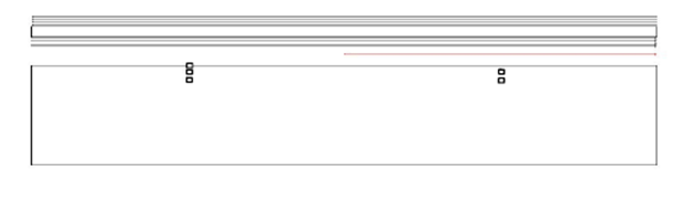

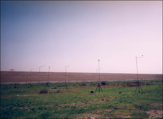
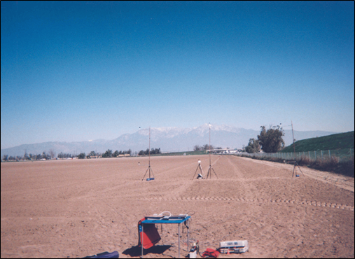
| Site ID | 10CA – open Measured two microphone lines: one with a berm (previously shown) and one with an open area (as shown and described here). |
|
|---|---|---|
| Location | Mira Loma, CA; Route 15; Southbound side; North of Limonite Ave Exit; field just North of Swan Lake Community | |
| Site Type | open area, flat | |
| Ground Type | plowed dirt, acoustically soft | |
| Roadway | 6 lanes, PCC, shoulders, hard soil median | |
| Instrumentation Positions | Microphones d = 98 ft (bb = 50 ft) height = 5 ft d = 118 ft (bb = 70 ft), height = 5 and 15 ft d = 158 ft (bb = 110 ft), height = 5 and 15 ft |
Meteorological Systems d = 138 ft (bb = 90 ft), height = 5 and 15 ft |
| Site ID | 10CA- open - TNM model |
|---|---|
| Default Ground Type | field grass |
| Pavement Type | average |
| TNM objects | roadways, receivers, ground zones (hard soil for median: width = 48 ft; loose soil for measurement field: width ~ 450 ft) |

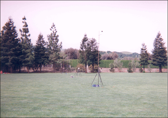
| Site ID | 11CA | |
|---|---|---|
| Location | Sunnyvale, CA; Route 237; Westbound side; just East of E. Caribbean Drive Exit; Eastern end of Sunnyvale Baylands County Park | |
| Site Type | barrier (16 ft wood), relatively flat | |
| Ground Type | field grass and some pavement, mixed acoustically soft and hard | |
| Roadway | 3 lanes + 2 auxiliary lanes, DGAC, shoulders, buffer zones, pavement median | |
| Instrumentation Positions | Microphones bb = 0 ft, height = 5 ft above barrier bb = 50 ft, height = 5 and 15 ft bb = 100 ft, height = 5 and 15 ft bb = 300 ft, height = 5 and 15 ft |
Meteorological Systems bb = 75 ft, height = 5 and 15 ft bb = 200 ft, height = 5 and 15 ft |
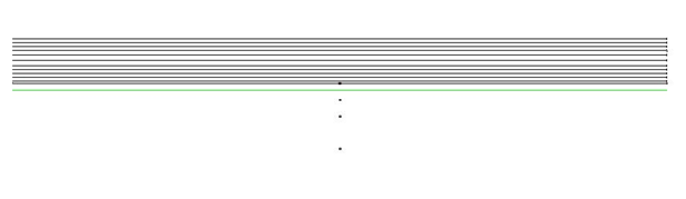
| Site ID | 11CA - TNM model |
|---|---|
| Default Ground Type | field grass |
| Pavement Type | average |
| TNM objects | roadways, receivers, barrier, terrain lines* (change in elevation of -4 ft from barrier base/roadway level to mic line), ground zone (pavement drive and parking area: largest width = 52 ft) |
*Since there is a slight incline from the 50-ft mic to the 300-ft mic, this was accounted for in the mic line using the z coordinate of the receivers (potentially important to the sound propagation path length). When first modeling the site, a terrain line was added to the back of the site, just beyond the 300 ft mic in order to apply the slight incline to the entire area, not just the mic line. It was shown that this additional terrain line did not affect the levels and was therefore removed.

| Site ID | 12CA | |
|---|---|---|
| Location | San Ramon, CA; Route 680; Northbound side; South of Bollinger Canyon Exit; Athan Downs Sports Fields (Northern most field) | |
| Site Type | barrier (12 ft concrete block), flat, with 6 ft drop-off from barrier | |
| Ground Type | lawn, acoustically soft | |
| Roadway | 8 lanes, PCC, shoulders, pavement median | |
| Instrumentation Positions | Microphones bb = 0 ft, height = 4 ft above barrier bb = 50 ft, height = 5 and 15 ft bb = 100 ft, height = 5 and 15 ft bb = 200 ft, height = 5 and 15 ft |
Meteorological Systems bb = 75 ft, height = 5 and 15 ft bb = 150 ft, height = 5 and 15 ft |
| Site ID | 12CA - TNM model |
|---|---|
| Default Ground Type | Lawn |
| Pavement Type | average |
| TNM objects | roadways, receivers, barrier, terrain line (change in elevation of -6 ft from barrier base to mic line), ground zone (pavement for strip next to barrier, not necessary) |
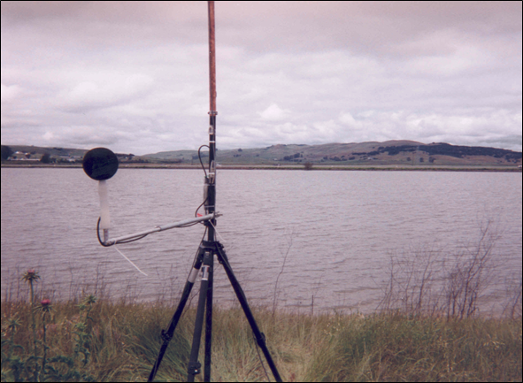
| Site ID | 13CA | |
|---|---|---|
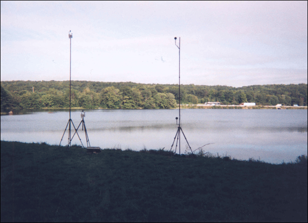
| Location | Sonoma, CA; Route 37; Eastbound side; ~0.5 mi East of Route 121; Tolay Creek Levee, San Pablo Bay National Wildlife Refuge | |
| Site Type | open area, relatively flat | |
| Ground Type | water, acoustically hard | |
| Roadway | 2 lanes, OGAC?, shoulders, pavement median | |
| Instrumentation Positions | Microphones d =50 ft (offset from mic line), height = 5 and 15 ft d = 900 ft, height = 5 and 15 ft |
Meteorological Systems d = 100 ft (offset from mic line), height = 5 and 15 ft d = 900 ft, height = 5 and 15 ft |
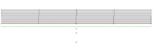
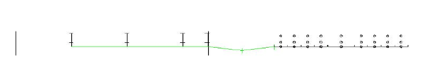
| Site ID | 13CA - TNM model |
|---|---|
| Default Ground Type | water |
| Pavement Type | average |
| TNM objects | roadways, receivers |


| Site ID | 14CA | |
|---|---|---|
| Location | Fremont, CA; Route 880; Northbound side; South of Stevenson Blvd Exit; Marshall Park | |
| Site Type | barrier (16 ft concrete block), flat, with 2 ft drop-off from barrier | |
| Ground Type | lawn and wood chips, acoustically soft | |
| Roadway | 8 lanes, DGAC, shoulders, pavement median | |
| Instrumentation Positions | Microphones bb = 0 ft, height = 5 ft above barrier bb = 50 ft, height = 5 and 15 ft bb = 100 ft, height = 5 and 15 ft bb = 150 ft, height = 5 and 15 ft |
Meteorological Systems bb = 75 ft, height = 5 and 15 ft bb = 135 ft, height = 5 and 15 ft |
| Site ID | 14CA - TNM model |
|---|---|
| Default Ground Type | field grass |
| Pavement Type | average |
| TNM objects | roadways, receivers, barrier, terrain line (change in elevation of -2 ft from barrier base to mic line), ground zone (lawn area: largest width ~ 180 ft, largest length ~ 400 ft) |

| Site ID | 15CA | |
|---|---|---|
| Location | Oakland, CA; Route 880; Northbound side; South of 66th Ave Exit; Oakland Stadium Parking Lot C (on South side of stadium) | |
| Site Type | open area, flat | |
| Ground Type | pavement, acoustically hard | |
| Roadway | 10 lanes, DGAC, shoulders, pavement median | |
| Instrumentation Positions | Microphones d = 40 ft, height = 5 and 15 ft d = 100 ft, height = 5 and 15 ft d = 200 ft, height = 5 and 15 ft d = 400 ft, height = 5 and 15 ft |
Meteorological Systems d = 105 ft, height = 5 and 15 ft d = 300 ft, height = 5 and 15 ft |
| Site ID | 15CA - TNM model |
|---|---|
| Default Ground Type | pavement |
| Pavement Type | average |
| TNM objects | roadways, receivers |

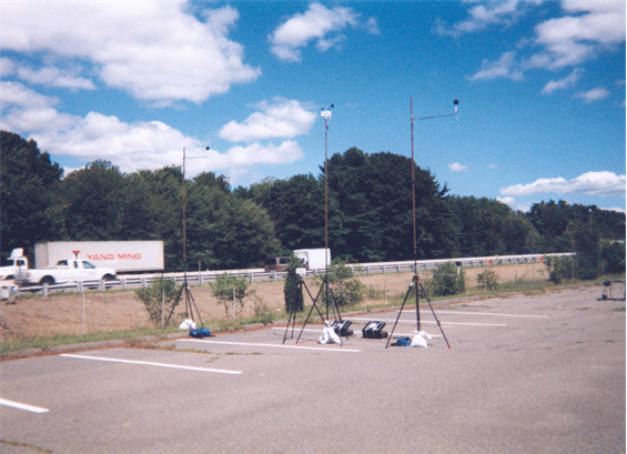
| Site ID | 16MA | |
|---|---|---|
| Location | Wayland, MA; Route 90; Eastbound side; East of Natick Exit (13); Cochituate State Park, farthest parking lot East of boat launch (adjacent to Route 30 overpass) | |
| Site Type | open area, flat | |
| Ground Type | mostly pavement with some lawn, acoustically hard and soft | |
| Roadway | 6 lanes, DGAC, shoulders, pavement median | |
| Instrumentation Positions | Microphones d = 78 ft, height = 5 and 15 ft d = 100 ft, height = 5 and 15 ft d = 150 ft, height = 5 and 15 ft d = 200 ft, height = 5 and 15 ft |
Meteorological Systems d = 90 ft, height = 5 and 15 ft d = 175 ft, height = 5 and 15 ft |
| Site ID | 16MA - TNM model |
|---|---|
| Default Ground Type | field grass |
| Pavement Type | average |
| TNM objects | roadways*, receivers, terrain lines (defining trench: depth = 4 ft), ground zone (pavement parking lot: width ~ 170 ft) |
*Highway traffic noise from farther distances to the West is blocked by a hill and an overpass; in order to concentrate more on a simple hard ground site, these shielding objects were not modeled, and, instead, the roadways were shortened.
| Site ID | 17CT | |
|---|---|---|
| Location | Stafford, CT; Route 84; Eastbound side; just East of Exit 72 | |
| Site Type | open, relatively flat | |
| Ground Type | water, acoustically hard | |
| Roadway | 6 lanes, DGAC, shoulders, grass median | |
| Instrumentation Positions | Microphones d = 60 ft, height = 5 and 15 ft d = 1273 ft, height = 5 and 15 ft |
Meteorological Systems d = 60 ft, height = 5 and 15 ft d = 1273 ft, height = 5 and 15 ft |
| Site ID | 17CT - TNM model |
|---|---|
| Default Ground Type | pavement |
| Pavement Type | average |
| TNM objects | roadways*, receivers, ground zone (field grass median: width = 18 ft) |
*Highway traffic noise from farther distances to the South is blocked by a hill and an overpass; in order to concentrate more on a simple hard ground site, these shielding objects were not modeled, and, instead, the roadways were shortened.