Previous Chapter « Table of Contents » Next Chapter
Hydraulic design considerations:
The term "hydraulic" refers to the field of science and engineering dealing with liquids. For purposes of this guidebook, hydraulic design covers concepts such as conveyance systems, channel behavior, and erosion control.1
This section introduces a key issue that engineers face in working toward environmentally sustainable solutions: smaller, more frequent storms are commonly ignored when designing flood control facilities. And yet, these storms are most often responsible for shaping the long-term health of these facilities and the larger roadside. A number of trade-offs are introduced in this section, followed by a set of strategies to help mitigate smaller, more frequent storm events. Example strategies include microcatchments, micro- terraces, slope transitions, bioretention, and multi-cell box culvert design.
The traditional approach to hydraulic design involves analysis of prescribed storm events and designing to mitigate such events. A Design Flood Event is typically either the 50- or 100-year storm. Smaller events, known as bank-full events, are responsible for shaping channels and ditches and defining where vegetation will grow. These bank-full events are typically characterized by the 2-year storm, which has a 50-percent chance of occurrence in any given year.
Traditional design practices require that hydraulic systems be designed for events ranging from the 10-year to the 500-year storm. Hydraulic design is based on roadway classification. Applicable design features for low standard roads are shown in Table 1.
| Design Feature | Standard | Flood Event |
|---|---|---|
| Culverts | High | 50-year |
| Low | 25-year | |
| Roadside Ditch | High | 10-year |
| Low | 10-year | |
| Longitudinal | High | 50-year |
| Embankment | Low | 25-year |
Source: FHWA PDDM
Typically, standard design methodologies ignore the lower intensity, more frequent storms since safety and replacement concerns dominate the design requirements. This section details design features which will enhance the systems for smaller, more frequent events, reducing the need for maintenance and extending the life of the system.1
Hydraulic design for roadways constructed by FHWA is dictated by the PDDM. Section 7.1.8 defines the Design and Check Flood for proposed drainage systems.
Defining a sustainable roadside requires identifying the characteristics of a "traditional" roadway and comparing historic techniques to new methodologies. In order to establish new methodologies, relationships with other disciplines must be formed to create innovative techniques to enhance the roadside. This approach mimics a typical FHWA Cross Functional Team (CFT) meeting environment where the Hydraulics Team pulls ideas from each of the other disciplines.
Hydraulics must work together with each of the other disciplines to develop strategies for conveying runoff (rainfall that exceeds infiltration) safely and efficiently. Coordination with revegetation and geotechnical disciplines, among others, is critical.
 HYDRAULIC DESIGN AND SAFETY
A delicate balance exists between providing structural hydraulic features and ensuring a smooth roadside surface for errant vehicles. Hydraulic obstructions may include, but are not limited to:
To mitigate these concerns, hydraulic facilities need to provide traversable surfaces to minimize slippages, overturns, and damages to vehicles (AASHTO, 2006).
Culverts should have many purposes in addition to simply conveying run-off. Culverts can serve as safe passages for small- to medium size wildlife. If culvert or wildlife crossing end sections fall within the clear zone, they must be protected from motorists using barriers or traversable grates. The trade-off is that grates often discourage wildlife crossings, which may result in increased wildlife collisions on the roadway (FHWA, 2008).
![]() VEGETATION: In order to create a stable conveyance
area, the correct landscape material must be determined. Vegetation
can protect slopes by reducing erosion and strengthening soil stability.
Utilizing the correct land cover is critical to creating a sustainable
roadside. The hydraulics group must determine flow rates and velocities
and confer with landscape professionals about materials that can be
established in the region and will be stable in the long term. In lieu
of or in combination with vegetation, rock material can also be utilized
to stabilize drainage ways. A soil-riprap mixture optimizes riprap
protection by providing a growing medium that contributes to stability.
VEGETATION: In order to create a stable conveyance
area, the correct landscape material must be determined. Vegetation
can protect slopes by reducing erosion and strengthening soil stability.
Utilizing the correct land cover is critical to creating a sustainable
roadside. The hydraulics group must determine flow rates and velocities
and confer with landscape professionals about materials that can be
established in the region and will be stable in the long term. In lieu
of or in combination with vegetation, rock material can also be utilized
to stabilize drainage ways. A soil-riprap mixture optimizes riprap
protection by providing a growing medium that contributes to stability.
Landscape professionals may also be consulted where issues of water quality must be addressed. Bioretention areas provide environmental benefits such as creating ideal growth mediums for filtration processes. Impacts to adjacent vegetation and natural systems need to be considered to ensure that roadway run-off does not overload the landscape with grease, oils, metals, or chlorides. Sediment and increased run-off impacts should also be reviewed.
Planning is critical in mitigating environmental impacts to vegetation and designing a sustainable roadside. Identifying the protected or sensitive areas will help establish the drainage patterns in the project. General concern with roadway impacts, such as grease or oil, metals, and chlorides, can be addressed with proper planning. In addition, run-off from impervious surfaces can generate erosion that increases sediment conveyance. Slowing run-off and spreading flow will help replicate predevelopment patterns.
![]() GEOTECH: Coordination with the geotechnical discipline
is needed when addressing slopes and roadside structures. In general,
flatter slopes are preferred but need to be balanced with potential
impacts to the surrounding environment. Stable slopes that resist erosion
and enhance vegetation growth are crucial to a sustainable environment.
Detailed analysis and coordination is especially important when a wall
is necessary, and optimal layout must be determined. Hydrostatic forces
create complex systems. Weepholes are often required for drainage from
backfill on the uphill side. Diversion of stormwater run- off using
concrete curbs and gutters allows water to be safely diverted around
the walls. In some instances, culverts are needed through the wall section
to collect runoff. Overall, coordination between disciplines to ensure
the proper wall design and stability is vital to enhancing the roadway.
GEOTECH: Coordination with the geotechnical discipline
is needed when addressing slopes and roadside structures. In general,
flatter slopes are preferred but need to be balanced with potential
impacts to the surrounding environment. Stable slopes that resist erosion
and enhance vegetation growth are crucial to a sustainable environment.
Detailed analysis and coordination is especially important when a wall
is necessary, and optimal layout must be determined. Hydrostatic forces
create complex systems. Weepholes are often required for drainage from
backfill on the uphill side. Diversion of stormwater run- off using
concrete curbs and gutters allows water to be safely diverted around
the walls. In some instances, culverts are needed through the wall section
to collect runoff. Overall, coordination between disciplines to ensure
the proper wall design and stability is vital to enhancing the roadway.
The construction process needs to ensure that hydraulic features are feasible and sustainable. Design of controls to convey run-off during construction can provide a basis for permanent facilities that provide water quality. Utilizing features such as terracing of slopes can increase the length of travel that run-off follows, increasing the ability of run-off to infiltrate. BMPs such as rock check dams also slow velocities, which reduce erosion potential and increase infiltration. Many of the features installed during construction can remain as permanent features, as long as the materials will hold up over time.
Hydraulic design often requires trade-offs when working toward solutions. These trade-offs must consider project context and scale. For example, traditional design typically plans for peak flow; whereas a more sustainable design considers the full spectrum of storm events. Hydrologic criteria for sustainable design must include consideration of flows resulting from more than 10-, 50-, and 100-year storm events. Culvert and bridge hydraulic design should take into account an approximate flow or storm frequency for the channel forming discharge. This is often defined as a 1.5-year to 2-year event. These frequency events are typically published and in many cases are suitable substitutes for estimating the channel forming discharge. In order to minimize impacts to channels (hydraulic and ecological), design of culverts should also account for normal flow by minimizing expansion or contraction of the river or stream within the crossing.
Conventional designs at streams or drainage ways tend to focus on larger precipitation events. However, small events typically generate the highest concentration of pollutants and contribute the most towards erosion. Conventional methods tend to concentrate run-off flows in roadside swales and in culverts. In smaller drainages where no defined channel existed before, the increase in concentration can result in unexpected erosion. When rivers or streams are constricted at crossings, sediment is often accumulated upstream of the road and erosion is increased downstream of the road (Figure 3-15). More specific considerations include the following:
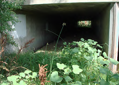
Figure 3-15: Large culvert following major storm event
Large culverts tend to collect sediment on the upstream end, limiting
the ability to convey flows during major storm events.
View larger version of Figure 3-16.1
View larger version of Figure 3-16.2
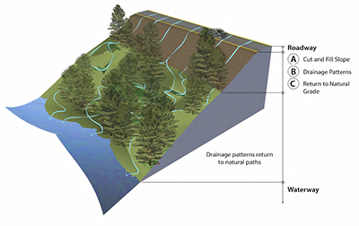
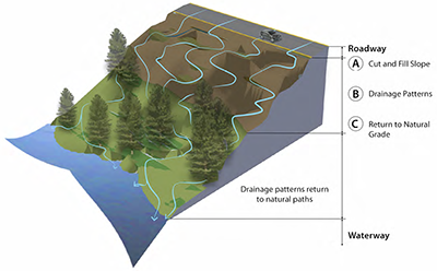
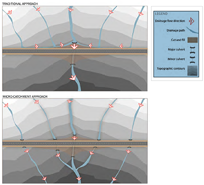
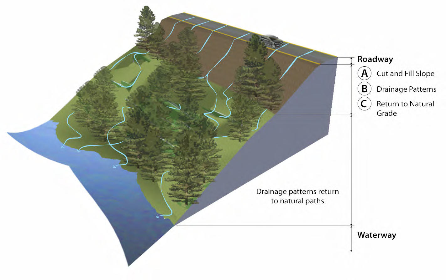
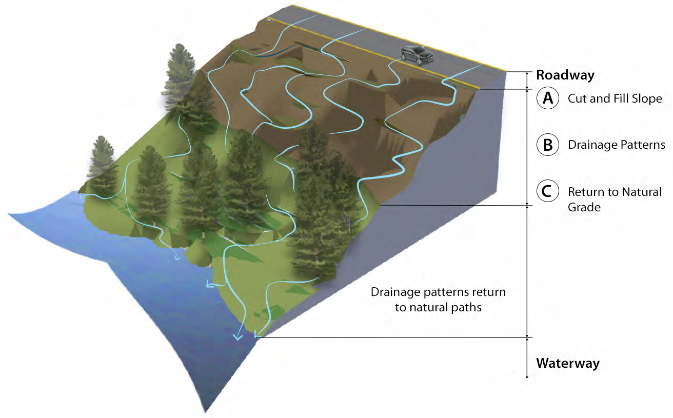
Figure 3-16: Flow paths
Lengthening flow paths (bottom
graphic) helps filter drainage before entering waterways.
Beyond the stream and drainage way crossings, creating a sustainable roadside involves the application of selected low-impact development (LID) strategies. Not all LID techniques work for rural roads and, for those that do, they may not work in every location. When applying LID or other methods in order to achieve increased roadside sustainability, each method should be evaluated carefully. Sample considerations include:
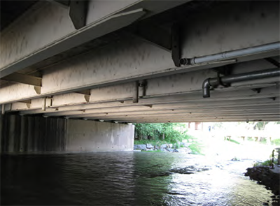
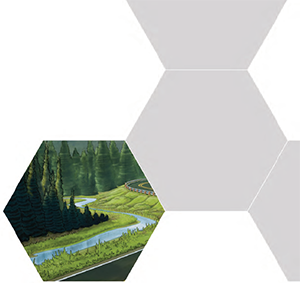
Figure 3-17: Drainage directly into a creek without treatment/infiltration strategies
Hydraulic facilities must be designed for multiple precipitation events starting with traditional major events but concentrating on the more frequent stream-forming events. This section outlines the design and approach for the hydraulic concepts previously discussed.
After the key requirements have been met for the hydraulic facilities, additional concepts can be designed to enhance the sustainability and the long-term function of the system. It is best to focus on smaller scale strategies, such as microcatchments, micro-terraces, terracing, vegetated buffers, filter strips, pervious paving, bioswales, and native vegetation.
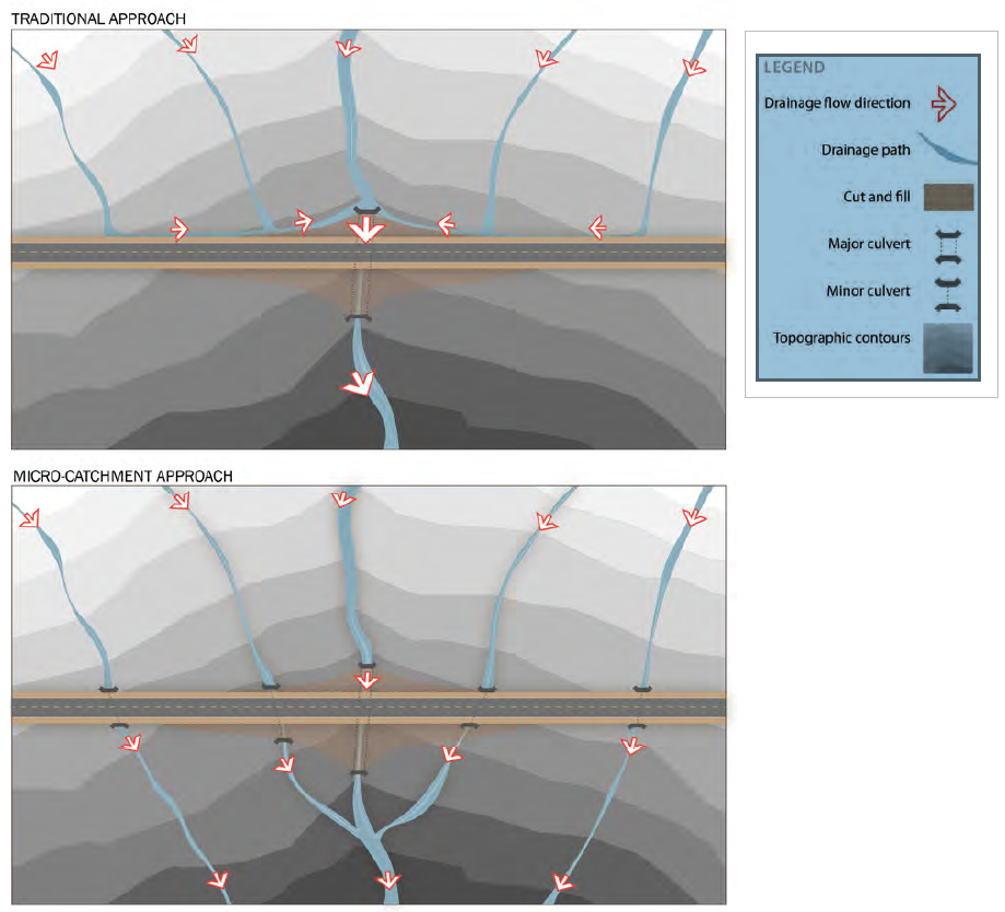
View larger version of Figure 3-18
Figure 3-18: Microcatchments
The installation of microcatchments allows smaller frequency events to cross the roadway, and can help reduce overall infrastructure costs.
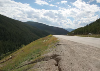
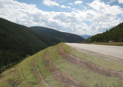
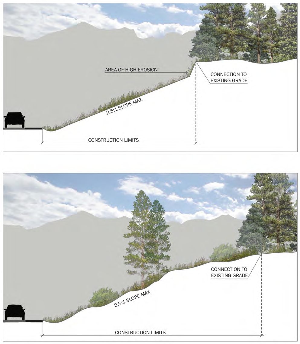
Figure 3-19: Micro-terraces (right) Micro-terraces replicate the natural environment to soften the roadway slope, promote infiltration and reduce run-off erosion.
View larger version of Figure 3-20
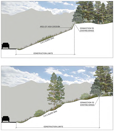
Figure 3-20: Slope transitions Providing slope transitions that link the interface between the existing and proposed slope by mimicking natural undulations can help lessen acceleration of stormwater and increase natural infiltration.
View larger version of Figure 3-21
Figure 3-21: Multi-cell box culvert This image shows the concept of a multi-cell box culvert, which places one cell floor lower than the other to keep normal channel flows and discharge confined to one cell.
There are multiple opportunities to apply techniques above and beyond the key requirements to create sustainable hydraulic solutions. Soil improvement is one example - when soil is improved, infiltration increases, which absorbs and stores water that would normally run off into water courses. It is important to keep water on the roadside to increase the amount of water available for vegetation, which in turn means better growth and less flooding.
Case Study
CHERRY CREEK DRIVE SOUTH
DENVER, COLORADO
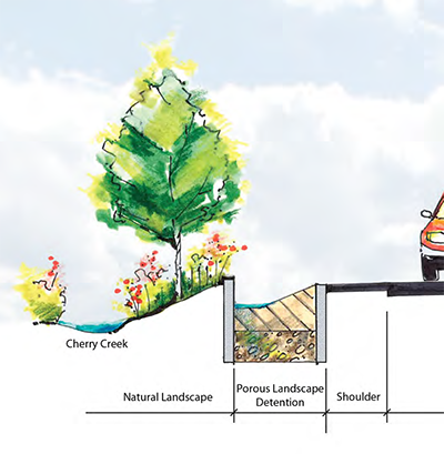
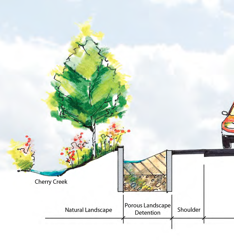
The concept of porous landscape detention (PLD) was used on the Cherry Creek Drive Project in Denver, Colorado. The design of a PLD consists of vegetation growing on a filtration mix underlain with large aggregate and drains. PLDs capture and filter run-off from a roadway before it enters ecologically sensitive areas.
The City and County of Denver installed PLDs on the Cherry Creek Drive project to preserve and protect water quality in Cherry Creek, which runs parallel to the corridor. Other project improvements included overall street reconstruction, new raised landscaped medians, construction of a new sidewalk, and a pedestrian/bicycle ramp connecting the sidewalk to the Cherry Creek trail system. Though this porous landscape detention example was placed in an urban environment, it could be applicable to rural roadsides where protection of sensitive environments (i.e., wetlands or waterways) is important.
Case Study
HALSTEAD MEADOWS
SEQUOIA AND KINGS CANYON NATIONAL PARK
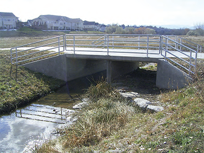
The Western Federal Lands Highway Division (WFL), in partnership with the National Park Service (NPS), are constructing a new bridge through Halstead Meadows in Sequoia and Kings Canyon National Park along Generals Highway. The project site is located 30 miles north of Three Rivers, California, and 70 miles east of Fresno, California, in Tulare County. The primary driver for construction of the bridge was to help resolve drainage and erosion issues. The at-grade roadway was functioning as a dam that altered the natural sheet flow condition of the meadow and concentrated water to two 36-inch-pipe culverts. The channelization resulted in creating scour upstream and downstream of the roadway and extended the length of the meadow.
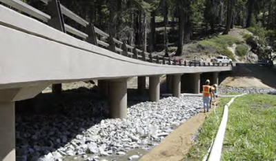
The goal of the project was to restore meadow hydraulics by constructing a 250-foot seven-span concrete bridge to replace the existing roadway. NPS worked on re-grading the meadow, replaced the former vegetation with native vegetation, and filled in the eroded drainage channel. NPS is monitoring the vegetation and ensured that the surface run-off does not drain into the formerly incised channel by using native material such as fill dirt, rocks, and logs to re-establish the sheet flow and prevent future erosion. Colored concrete was used and stone guardrails were placed at the four corners of the bridge to enhance the surrounding environment.
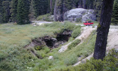
The roadway before project construction
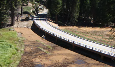
The bridge under construction
Photo Source: National Park Service and Parsons Brinckerhoff
Detailed Strategies/Low Impact Development Techniques
Vegetation
Geotech
Aesthetics
Construction Practices
Stay up to date
Sign up for announcements on grant opportunities, training, and webinars.


