Previous Chapter « Table of Contents » Next Chapter
When planning, designing and evaluating wildlife crossings, it is important to remember that every mitigation plan will be different, and it is not always possible to extrapolate results or expectations across political boundaries or landscapes. Each mitigation scheme has its own set of wildlife components, population connectivity concerns, transportation objectives, and land management priorities. The requirements for mitigation and plans prepared may be vastly different between adjacent watersheds, municipalities, states/provinces and countries.
These political, management and landscape-related issues should guide the planning process and will play an important role when designing effective mitigation for wildlife populations.
The most common management questions that arise in the planning stage are:
In this chapter we will address the first question. The second question will be covered in Chapter 4 and question three will be explored in Chapter 5.
Mitigation is only one of the planning alternatives transportation agencies have to reduce or eliminate impacts of road construction and expansion projects. Transportation projects can (1) have road alignments that avoid critical wildlife habitat, (2) mitigate affected wildlife populations and habitats, or (3) compensate for the loss of wildlife habitat as Figure 11 shows.
Before initiating project planning for wildlife habitat connectivity, the first step in avoiding impacts from road construction on wildlife populations and their habitats is to make alignment adjustments to prevent conflicts. The majority of major road construction projects today are expansions or reconstructions, so there may be few opportunities to avoid critical habitats with existing alignments. Some road expansion projects may encroach upon wetland habitats, but chances are based on proximity alone, the existing road has impacted them to some extent.
Road construction or expansion projects may be unable to avoid habitats completely, but road alignments can be planned to minimize impacts to wildlife. Having roadways traverse suboptimal habitat for wildlife can help reduce adverse effects, e.g., alignments on north-facing slopes. Roads that bisect optimal habitat generally have more adverse effects on wildlife compared to those in peripheral, suboptimal habitat illustrated in Figure 12.
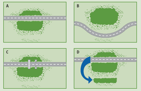
Figure 11. Schematic. Representation of road construction and habitat (A) fragmentation
View larger version of Figure 11.
(B) avoidance (C) mitigation by use of under/overpasses, and (D) compensation by creation of replacement habitat nearby (from Iuell et al. 2005).
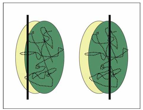
Figure 12. Schematic. Location of alignment of highways with respect to habitat quality may have differential impacts on wildlife movements (dotted line). The impact of a highway alignment located on the periphery in sub-optimal habitat (yellow) would be expected to impact wildlife movements less than if the disturbance equally bisected optimal habitat (green).
If the impacts cannot be avoided, then mitigation is an alternative. In North America this is the most common approach when roads impact wildlife habitat. Today there are many examples of mitigation techniques and strategies implemented for wildlife in nearly every North American landscape.
Finally, if projects are unable to avoid or mitigate their impacts then the third option consists of compensation measures. The compensation principle holds that for road construction or expansion there is no net loss of habitat, natural processes or biodiversity. This principle is commonly applied in transportation projects throughout North America through the National Environmental Protection Act (NEPA) in the United States and the Canadian Environmental Assessment Act (CEA).
Project-level and systems-level approaches are two different scales of habitat connectivity planning and means of incorporating measures to reduce the effects of roads on wildlife populations. Project-based approaches are most common with transportation agencies, although systems-level approaches that encompass entire states and provinces have become more common in the last few years.
Mitigating roads for wildlife conservation is most economical during road expansion or upgrade projects. Thus, funding for road mitigation measures such as wildlife crossing structures is most likely to originate from specific transportation projects that address multiple transportation management concerns, one of which may reduce vehicle collisions with wildlife and provide safe passage across busy roadways.
This project-level approach is concerned with proximate objectives - i.e., those within the transportation corridor and occasionally lands adjacent to it as mapped in Figure 13. A project- level focus may not necessarily consider how the wildlife crossing structures fit into the larger landscape and regional wildlife corridor network. Wildlife crossings should not lead to ecological "dead-ends" or "cul-de-sacs," where wildlife have nowhere to go, but must link to a larger regional landscape and habitat complex that allows them to disperse, move freely, and meet their daily and life requisites. This requires not only large spatial-scale considerations but should also incorporate future (or projected) land-use change into the planning process.
Wildlife crossings may also emerge from a systems-level analysis of transportation management concerns and priorities over a much larger area than transportation corridor projects. Rather than seeking to place a specific crossing structure (± 1 mile), the systems perspective identifies which stretches of highway should require mitigation (± 10 - 100 miles) and how intensive the mitigation should be. Key wildlife crossing areas may also be identified from a regional landscape assessment of wildlife connectivity needs around a state-/province-wide road system or regional transportation corridor.
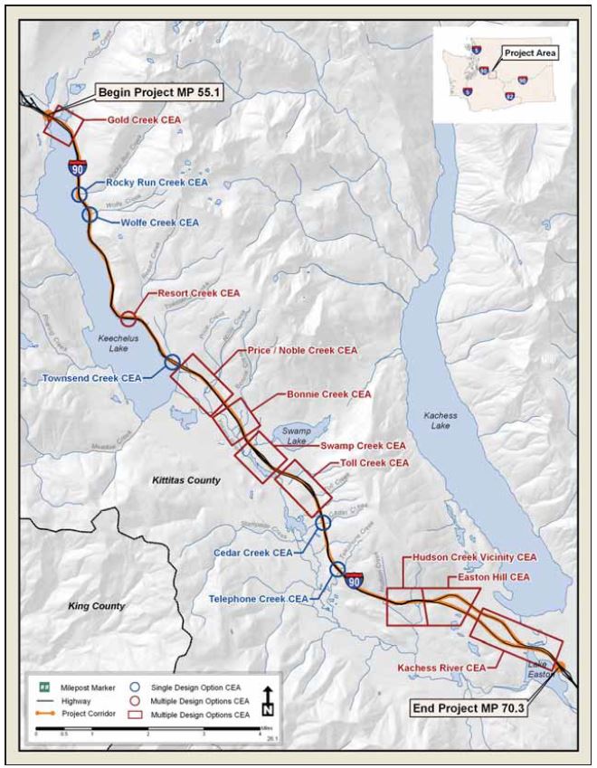
Figure 13. Map. A project-scale analysis of connectivity emphasis areas (CEA) for the Interstate 90 Snoqualmie Pass East project area, Washington State. These are locations where wildlife crossing mitigations are proposed to be installed
(Source: Washington State Department of Transportation).
View larger version of Figure 13.
This landscape-focused approach can be viewed as the inverse of the project-level, or corridor- focused approach. With the right information it is possible to identify key habitat linkages or zones of important connectivity for wildlife that are bisected by transportation corridors as the Figure 14 map shows. Linkages and potential wildlife crossing locations can be prioritized based on future transportation investments, scheduling, ecological criteria and changing climate regimes. This helps to strategically plan mitigation schemes at a regional or ecosystem level.
This landscape-level approach, which is institutionalized in most of Europe, is gaining appeal with North American transportation agencies. In the United States, the overlay of two state agency maps - Statewide Transportation Improvement Program (STIP) plans with comprehensive Wildlife Conservation Plans from natural resources agencies - facilitates the integration and coordination of spatially explicit transportation and wildlife habitat conservation plans at the state level. A recent policy by the Western Governors' Association to "protect wildlife migration corridors and crucial wildlife habitat in the West" sets a management directive to coordinate habitat protection and land use management for wildlife across jurisdictional boundaries. Of particular note was the section of the report produced by the Transportation Infrastructure Working Group, which makes detailed recommendations on ways to integrate future transportation planning with wildlife habitat conservation at the systems level.
Climate change has been inducing range shifts for many species during the last century. The potential impacts of climate change, coupled with an increasingly fragmented North American landscape less permeable for wildlife dispersal, will require conservation planning that enables wildlife to move and adapt to changing climatic conditions. Incorporating climate change scenarios in systems-level planning of transportation infrastructure makes good sense given the importance of crossing structures in allowing species affected by climate change and habitat fragmentation to expand their range into new climatic space.
There are substantial benefits from the systems-level analysis. By establishing a formal, broad- scaled planning process, it is possible to readily address stakeholder concerns, prioritize agency objectives, and incorporate landscape patterns and processes and climate change into the planning and construction process. It also helps ensure that project-level efforts contemplate the larger ecological network in the surrounding region. This results in more streamlined projects that save transportation agencies money over the long term.
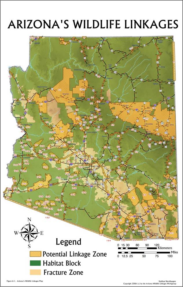
Figure 14. Map. Statewide mapping of highways and fracture zones, blocks of wildlife habitat and connectivity linkage zones for Arizona (Source: Arizona Wildlife Linkages Work Group).
View larger version of Figure 14.
ECO-LOGICAL
Infrastructure consists of the basic facilities - such as transportation and communications systems, utilities, and public institutions - needed for the functioning of a community or society. Sometimes the development of these facilities can negatively impact habitat and ecosystems. Techniques have been developed to better avoid, minimize, and mitigate these impacts, as well as the impacts of past infrastructure projects. However, the avoidance, minimization, and mitigation efforts used may not always provide the greatest environmental benefit, or may do very little to promote ecosystem sustainability. The most important sites for long-term ecological benefits may be "off-site" or outside the project area. This concern, along with a 1995 Memorandum of Understanding to foster the ecosystem approach and the Enlibra Principles, mobilized an interagency Steering Team to collaborate over a three-year period to write Eco- Logical: An Ecosystem Approach to Developing Infrastructure Projects (Brown 2006).
Eco-Logical encourages Federal, State, tribal, and local partners involved in infrastructure planning, design, review, and construction to use flexibility in regulatory processes.
Specifically, Eco-Logical puts forth the conceptual groundwork for integrating plans across agency boundaries, and endorses ecosystem-based mitigation - an innovative approach of mitigating infrastructure impacts that cannot be avoided.
Eco-Logical is a guide to making infrastructure more sensitive to wildlife and ecosystems through greater interagency cooperative conservation. It describes ways for streamlining the processes that advance approvals for infrastructure projects - in compliance with applicable laws - while maintaining safety, environmental health, and effective public involvement. As a way to accomplish this, the guide outlines an approach for the comprehensive management of land, water, and biotic and abiotic resources that equitably promotes conservation and sustainable use. Key components of the approach include integrated planning, the exploration of a variety of mitigation options, and performance measurement.
Deciding where to locate wildlife crossing structures requires adequate tools and resources to identify the most suitable sites for crossing structures at the project and systems level. Listed below are resources that can help define the important wildlife linkages across roads and identify key areas for mitigation.
Many resources are available today that facilitate the identification of wildlife habitat linkages and movement corridors. Many electronic resources are geographic information system (GIS)- based, readily available from government or non-governmental agencies, and can be downloaded from Internet sites, e.g., state/provincial or national Geospatial Data clearinghouses. Some basic map and data resources for planning wildlife connectivity and crossing mitigation include:
Table 1 describes each resource and how it can be used for project-level and systems-level planning of wildlife habitat connectivity and highway mitigation. Use of these resources in combination with road network and traffic data is an ideal place to start identifying the intersections of high probability habitat linkages and roads. Combining multiple resources will provide greater accuracy in identifying habitat linkages and finalizing site selection for wildlife crossing structures. Most of the resources listed in Table 1 work best at the more localized, project level, however some can be used or adapted for larger, systems-level assessments.
| Map/Data Type | Project-level | Landscape-level |
| Aerial photos | Photos can be used to help identify vegetation types and human developments. Photos come in many scales and image formats (ortho-photos, color infrared, black and white). Some images are high resolution (to 5 m). Readily available from local and state/provincial government agencies. | Typically not practical to use for large landscape-scale assessments of linkage zones. Landsat TM satellite imagery or other remotely sensed imagery are good substitutes for working at a state/provincial scale. Satellite imagery should be available at most local and state/provincial government agencies. |
| Land cover-vegetation maps | These maps help identify general vegetation types such as deciduous vs coniferous forests, shrublands, grassland/marshes, rock and ice. Land cover maps are more general and include physical (built areas) and biological information. Readily available from local and state/provincial government agencies and their websites. | Maps are available for large-scale habitat and corridor network planning. The scale is much larger and resolution lower, nonetheless important resource to use in large scale planning endeavors. Readily available from local and state/provincial government agencies and their websites. |
| Topographic map | Information on slopes, ridgelines, valley bottoms, drainages and other main topographic features are valuable for identifying wildlife habitat corridors. Roads, power lines and other human developments are usually found on these maps. Readily available from local and state/provincial government agencies. | Like land cover-vegetation maps above, topo maps are available for state/provincial-wide mapping exercises, however resolution is lower. Readily available from local and state/provincial government agencies. |
| Landownership map | Coordinating management of lands adjacent to roads is key to successful mitigation. Maps that identify adjacent land use management such as public/crown lands, designated reserves, municipal and private lands are needed for planning corridors and crossings. Readily available from local and state/provincial government agencies. | Also available for large scale planning endeavors. Generalized vegetation and land-use types are provided. Readily available from local and state/provincial government agencies. |
| Wildlife habitat map | Generally developed from combination of biophysical maps (vegetation maps being one) and models of habitat suitability for certain wildlife species or groups. They identify key habitat types for the species for which they are prepared. Some are very accurate and derived from site-specific studies, while others are less accurate relying on extrapolated information. Readily available from local and state/provincial government agencies and NGOs. | Some states have prepared (or are in preparation) statewide habitat connectivity maps (e.g., FL, WA, CA). In the U.S., state natural resource agencies have prepared "comprehensive wildlife conservation plans" that identify statewide, key habitats for wildlife conservation. These should be readily available from most, if not all, state natural resource agencies today. |
| Wildlife movement model | Similar to wildlife habitat maps but more specific to where wildlife are most likely to move through the landscape. These are based on either expert opinion or empirical studies that integrate species ecology and landscape suitability. Generally available from wildlife agencies conducting the modeling research. |
Generally not available for large-scale exercises unless designed specifically for that purpose. Least-cost path and circuit theory modeling may be promising methods at this scale. |
| Wildlife ecology field data | Supplemental data in form of telemetry points or population surveys can help guide the location selection for connectivity and crossing structures. Generally available from wildlife agencies conducting research in the project area. | Not generally available for state/provincial-wide work, however, local data can be extrapolated to larger landscapes to aid in habitat corridor planning. |
| Road-kill data | Many state/provincial transportation agencies collect location-specific data on wildlife species killed on their roads, either through carcass collections or collision reports. These data are primarily collected for large mammals and rarely for small or medium-sized fauna. These data can be used to identify road-kill hotspots, but do not provide information on where wildlife are successfully crossing the roadway. | Data are readily available from state/provincial transportation agencies, usually collected by districts and then stored in a state/provincial-wide database. These data can be used to identify most critical sections of state/provincial highway for accidents with large mammals (primarily elk and deer). |
| Road network | Municipal and state/provincial governments have digital information on all road types in their jurisdiction. | Road data from state/provincial to national scale can be obtained from the U.S. Census Bureau geospatial database or GeoConnections in Canada. |
GIS analysis is widely used in transportation and natural resources management today. Analyses can be done in multiple spatial scales ranging from project to landscapes and regions. Many of the map and data resources listed above are available in digital format and can be overlaid and analyzed in ArcView/GIS® or ArcMap®. Basic GIS layers useful for identifying habitat linkages and siting wildlife crossings at the systems-level include:
Generally habitat linkage assessments at the systems-level are not suitable for identifying specific locations for wildlife crossings due differences in design considerations, e.g. broad-scale movement patterns of large carnivores versus local topographic and engineering concerns. However, a linkage assessment can help prioritize and identify where wildlife - road conflict areas occur over a large area. Once identified, this is a good starting point for initiating discussions with transportation and regulatory agencies about mitigation plans in the short and long term.
Determining the specific placement or siting of wildlife crossings is generally done at the project-level, or after a thorough field survey as part of a larger systems-level assessment. Regardless of the method, considerations of wildlife crossing placement begin by determining the wildlife species or groups of concern as discussed later in Chapter 4. Once the focal species or group is identified, many of the resources listed above can be used to identify the best locations for wildlife crossing mitigation. Methods to identify those locations are briefly described below. It is critical to make a field visit and be on the ground at the potential location for any wildlife crossings regardless of the tools or techniques used.
Below we describe several different approaches used by transportation agencies to location wildlife crossing structures.
Intuitively road-kill data would be best suited for determining where wildlife crossings should be placed. However, research suggests that the locations where wildlife are struck by vehicles may have little in common with where they safely cross roads. Many factors associated with roads and adjacent habitats can be the causes of wildlife - vehicle collisions and these factors may not influence where wildlife safely cross roads. Use of road-kill data alone provides a very limited scope of wildlife movement areas and should be combined with habitat linkage mapping or movement models (see below). If reducing road-kill and increasing habitat connectivity is a project objective, then identifying the location of safe wildlife crossings will be an important consideration in planning crossing structures.
Telemetry has been commonly used to describe successful road crossing locations usually through intensive monitoring of wildlife movements. More accurate crossing data are now being obtained using global positioning system (GPS) monitoring devices and satellite-based telemetry captured in Figure 15. Satellite methods allow for more frequent and more accurate relocation data while the animal is collared when compared to radio-based methods.
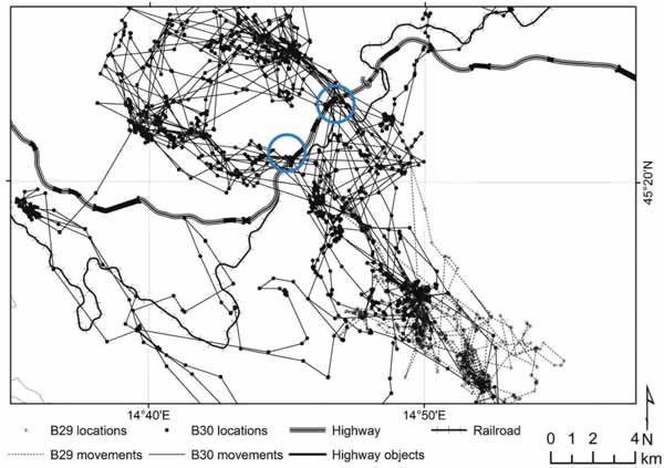
Figure 15. Map. Global position system (GPS) movement data from a male brown bear crossing a major four-lane highway and wildlife crossings (blue circle) in Croatia (Source: D. Huber, Zagreb University).
View larger version of Figure 15.
By live-trapping and marking individuals and monitoring their movements via translocation or natural movements across roads, the distribution and population density of wildlife can be identified. This approach is most common among smaller fauna, but is becoming less popular as more non-invasive survey methods are being developed.
In areas that receive regular snowfall, transects adjacent and parallel to the road or road surveys carried out while driving slowly along the road edge are two commonly used techniques to identify animal crossing locations.
Beds of sand or other tracking medium laid out along sections of roadway to intercept animal movements across roads as shown in Figure 16 have been used to estimate the number of animal crossings before road expansion and constructing wildlife crossings. These data can be used to determine the duration of monitoring required to detect a proportional change in crossing rates after construction.
(A) (B)
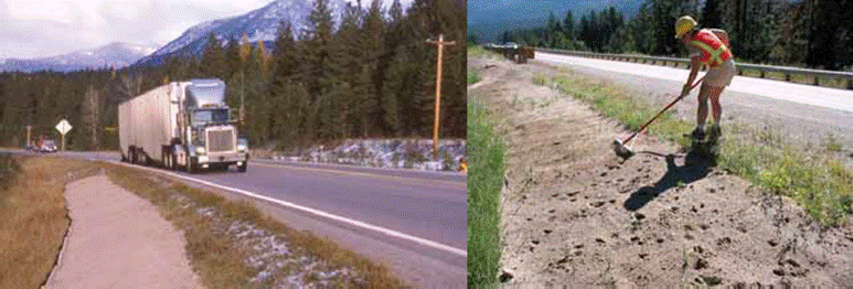
Figure 16. Photo. (A) Use of track beds is one method for obtaining information on wildlife movement across roads and key crossing locations prior to installation of wildlife crossing structures. (B) Raking of track beds along US 93 in Montana to collect pre- mitigation information on wildlife movements in the highway corridor (Credits: M. Huijser).
Camera systems along roads have their own inherent operating problems and have not proven to be a reliable method of obtaining information on where animals actually cross roads. These problems are related to a camera's limited range of detection. However, camera data can be used to provide information on wildlife distribution and relative abundance by using camera "traps." Camera sampling stations can be placed in the study area (road corridor) using a grid or stratified sampling approach that will provide the best results per unit of effort. Animal distributions can be modeled using presence-only data from cameras. Determining relative abundance is more problematic, as it is difficult to identify individual animals detected by cameras.
Similar to camera traps, non-invasive genetic sampling of hair for DNA analysis may be practical if used in a high-density grid pattern and/or focusing efforts at a smaller scale of resolution (e.g., medium-sized mammals). A genetic sampling grid used for obtaining hair samples from bears in Banff National Park, Alberta, is shown in Figure 17. Genetic sampling may only be able to provide general information on the potential location of wildlife crossing structures. Unlike data from camera systems, genetic sampling and DNA analysis can provide minimum estimates of local population size and identify individuals, their gender and genetic relatedness.
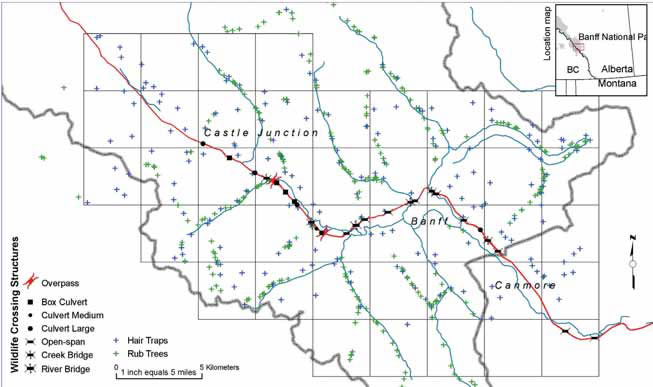
Figure 17. Map. DNA sampling grid in Banff National Park. Hair snag sites and rub tree sites were used to collect population genetic data on individuals in the population and from bears using the wildlife crossings on the Trans-Canada Highway (Source: WTI/Parks Canada).
View larger version of Figure 17.
Landscape-scale GIS-based models have been used to identify key habitat linkages, evaluate habitat fragmentation resulting from human activities, and discover areas where highways are permeable to wildlife movement. Models that simulate movements of wildlife tend to use "resource selection functions" that map habitat quality. The models have rules for simulated movements based on habitat quality and how animals are able to travel through the landscape. The data used to generate a GIS-generated "habitat surface" for these models is based on some type of information on animal distribution, usually obtained by radiotelemetry locations, but can also be derived from other methods to survey animal populations, such as genetic sampling, sooted track plates, acoustic surveys or scat-detection dogs. Regardless of how the simulated movement or habitat linkage models are developed, the model's ability to predict crossing locations needs to be tested with empirical field data, e.g., road-kill locations, telemetry location data, field observations, transects and survey data, etc.
WHAT IS A RESOURCE SELECTION FUNCTION?
Resource selection functions (RSFs) estimate the relative amount of time an individual animal spends using a resource (e.g., habitat type) as a function of the proportional availability of that resource. The units being selected by animals (e.g., habitat types) are conceived as resources, and predictor variables associated with these resource units may be "resource" variables or covariates of the resources - e.g., elevation, human disturbance. RSF models are similar to methods that have been developed for mapping distributions of animals using species environment patterns. A RSF model can be considered a form of habitat suitability index (HSI; U.S. Fish and Wildlife Service 1981), but with statistical rigor. RSF models are always estimated directly from data. A RSF usually is estimated from observations of (1) presence/absence (used vs. unused), or (2) presence/available (used vs. available) resource units (Boyce et al. 2002). When linked to a geographic information system (GIS), RSF models can be powerful tools in natural resource management, with applications for cumulative effects assessment, land management planning, and population viability analysis.
Often transportation and natural resource agencies lack easily accessible field data for planning the location of wildlife crossing structures. Usually decisions regarding design and location need to be made in a few months leaving no time for preconstruction studies. When this is the case, there are several options to consider.
Expert information can be used to develop simple, predictive, habitat linkage models in a relatively short period of time. Expert information may consist of models based on the opinion of experts or qualitative models based on the best available information obtained from the literature. Several methods have been used to quantitatively analyze expert opinion data, but the analytical hierarchy process (AHP) is popular among environmental biologists. Expert opinion has been successfully used to identify key habitat linkages across roads and site wildlife crossings. The advantages are: (1) it is quick and easy to carry out; (2) legitimacy can be quite high if a consensus-model is employed by participants; (3) the method can be statistically sound and biologically robust for identifying and prioritizing critical habitat linkages; and (4) GIS software to assist in linkage identification is readily available. Software for the AHP is freely available on the Internet, and was designed by AHP authority Thomas L. Saaty. Major limitations of expert-based modeling are that it works best when having a narrow taxonomic focus, and like all models they are best when validated with field data. There are also important considerations for determining who is invited as an expert and how transparent the process is when it comes to finding broader support for the findings of the model. Like all models, it must be validated with field data, like those shown above.
A rapid assessment process has been used that involves gathering experts from the area of concern. This process differs from the expert-based habitat model in that there is no quantitative analysis of expert opinion or modeling. Through consensus participants delineate where they believe key corridors are located on a given section of highway. The advantages are similar to the above model, however they can have a broad taxonomic focus. The main shortcomings are criteria are rarely used for the selection of potential linkage areas, and (2) a lack of decision rules or weighting of factors considered makes it difficult to identify and prioritize the most critical linkages in a biologically robust way. As such, large sections of highway may be deemed "critical" when actually a smaller subset and the most ecologically important linkages are not teased out and identified. Also, rapid assessment results are rarely validated with field data.
Historically, local knowledge has been important for wildlife biologists conducting research or managing habitats for wildlife. Long-term residents can provide valuable information about where and how wildlife moves across the land. In landscapes where crossing locations are limited, local knowledge can help guide the planning of wildlife crossings. Local participation in project planning is not only good public relations but also provides stakeholders with input and participation in the project. Local knowledge and public participation have been formalized through citizen-scientist programs. These programs encourage active participation by the local community in wildlife movement and road mortality data collection.
The most important part of site selection for wildlife crossing structures is the compatibility of adjacent land use in the present and future. Wildlife crossings will only be as effective as the management strategies developed around them that incorporate all the key landscape elements (humans, terrain, natural resources, transportation). Wildlife crossings are in essence small, narrow, site-specific habitat corridors. Thus, for these measures to fulfill their function as habitat connectors, mitigation strategies must be contemplated at two scales. Site-level or local-scale impacts from development or human disturbance adjacent to crossing structures may impede wildlife use. Similarly, alteration of landscape elements at a broader regional-scale could impede or obstruct movements towards the crossing structures and prevent animals from using them, thus rendering them ineffective. The larger scale concerns must be recognized if the local- scale measures are to be effective.
Coordination between land management and transportation agencies, and in some cases municipal planning organizations, can reconcile the connectivity concerns at both scales. If a transportation agency designs and builds appropriate wildlife crossings, but the land management agency fails to manage adjacent lands, the transportation agency funds will be wasted and the measures likely ineffective. Similarly, if adjacent lands are managed to ensure regional-scale connectivity across a highway, but the transportation agency fails to provide appropriate wildlife crossing structures, then efforts of the land management agency will be of limited value.
In developing recommendations for mitigating with wildlife crossings, it is important to remember the temporal and spatial context of ecosystems. Mitigating highways for wildlife is a long-term process that will last for many decades and affect individuals and populations alike. Thus, highway mitigation strategies developed around land-use planning should not terminate with the construction process. They need to be proactive at both local and regional scales to ensure that crossing structures remain functional over time.
Like bridge structures, the lifespan of wildlife crossing structures is 75 - 80 years, so mitigation needs to be thought of as long term. The planning of wildlife crossing mitigation requires forecasting, visualization and understanding how to proactively integrate wildlife conservation concerns around a growing infrastructure and a changing landscape.
Long-term planning needs to take into consideration not only change in land use but also range shifts due to climate change. Crossing structures are practical measures that transportation agencies can integrate into state or regional planning exercises to help adapt changes in species ranges and animal distributions to climate change. The potential impacts of climate change, coupled with an increasingly fragmented North American landscape less permeable for wildlife dispersal, will require conservation planning that enables wildlife to move and adapt to changing climatic conditions. Incorporating climate change scenarios in systems-level planning of transportation infrastructure makes good sense given the importance of crossing structures in allowing species affected by climate change and habitat fragmentation to expand their range into new climatic space.
Beier, P., K.L. Penrod, C. Luke, W.D. Spencer and C. Cabanero. 2006. South Coast missing linkages: restoring connectivity to wildlands in the largest metropolitan area in the USA. Pages 555-586, in K Crooks and M. Sanjayan (eds.), Connectivity conservation. Cambridge University Press, Cambridge, UK.
Beier P, D.R. Majka and W.D. Spencer WD. 2008. Forks in the road: Choices in procedures for designing wildland linkages. Conservation Biology 22:836-851.
Bissonette, J.A. 2007. Evaluation of the use and effectiveness of wildlife crossings. National Cooperative Highway Research Program (NCHRP) 25-27 final report. Transportation Research Board, Washington DC.
Boyce, M.S., P.R. Vernier, S.E. Nielsen, and F.K.A. Schmiegelow. 2002. Evaluating resource selection functions. Ecological Modelling 157:281-300.
Chetkiewicz, C-L.B., Cassady St. Clair, C. and Boyce, M.S. 2006. Corridors for conservation: integrating pattern and process. Annual Review of Ecology and Systematics 37:317-342.
Clevenger, A.P., J. Wierzchowski, B. Chruszcz, and K. Gunson. 2002. GIS-generated expert based models for identifying wildlife habitat linkages and mitigation passage planning. Conservation Biology 16:503-514.
Clevenger, A.P., Chruszcz, B., Gunson, K., and Wierzchowski, J. 2002. Roads and wildlife in the Canadian Rocky Mountain Parks - Movements, mortality and mitigation. Final Report (October 2002). Report prepared for Parks Canada, Banff, Alta.
Cuperus, R., K.J. Canters, A. Udo de Haes, and D.S. Friedman. 1999. Guidelines for ecological compensation associated with highways. Biological Conservation 90:41-51.
Forman, R.T.T., Sperling, D., Bissonette, J., Clevenger, A., Cutshall, C., Dale, V., Fahrig, L., France, R., Goldman, C., Heanue, K., Jones, J., Swanson, F., Turrentine, T. and Winter, T. 2003. Road ecology: Science and solutions. Island Press, Washington, D.C.
Kintsch, J. 2006. Linking Colorado's landscapes. Pages 138-142 in Proceedings of the 2005 International Conference on Ecology and Transportation, edited by C. Leroy Irwin, Paul Garrett, and K.P. McDermott. Raleigh, NC: Center for Transportation and the Environment, North Carolina State University.
Lee, T., M.S. Quinn, D. Duke. 2006. Citizen, science, highways, and wildlife: Using a web- based GIS to engage citizens in collecting wildlife information. Ecology and Society 11(1): 11 https://www.ecologyandsociety.org/vol11/iss1/art11/
Long, R. A., P. MacKay, W. J. Zielinski, and J. C. Ray, editors. 2008. Noninvasive survey methods for carnivores. Island Press, Washington D.C., USA.
National Research Council (NRC). 2005. Assessing and Managing the Ecological Impacts of Paved Roads. The National Academies Press, Washington, DC.
Saaty, T. L. 1990. How to make a decision - the Analytic Hierarchy Process. European Journal of Operational Research. 8:9-26.
Singleton, P.H., W.L. Gaines, and J.F. Lehmkuhl. 2002. Landscape permeability for large carnivores in Washington: a geographic information system weighted-distance and least- cost corridor assessment. USDA Forest Service research paper, PNW-RP-549.
Smith, D. 1999. Identification and prioritization of ecological interface zones on state highways in Florida. Pages 209-230 in G.L. Evink, P. Garrett, and D. Zeigler, editors. Proceedings of the Third International Conference on Wildlife Ecology and Transportation. FL-ER-73-99. Florida Department of Transportation, Tallahassee, Florida. 330 pp.
SREP. Safe passages. 2007. Southern Rockies Ecosystem Project, Denver, CO.
Transportation Research Board, 2004. Environmental spatial information for transportation: a peer exchange on partnerships. Conference proceedings on the web 1. National Academy Press, Washington, D.C.
US Fish and Wildlife Service. 1981. Standards for the development of suitability index models. Ecology Service Manual 103, US Fish and Wildlife Service, Division of Ecological Sciences, Washington DC, USA.
Van Manen, F.T., Jones, M.D., Kindall, J.L., Thompson, L. and Scheick, B.K. 2001. Determining the potential mitigation effects of wildlife passageways on black bears. Proceeding of the International Conference on Ecology and Transportation 2001:435-446.
Western Governors' Association. 2008. Wildlife corridors initiative report. Western Governors' Association, Denver, CO.
White, T. 2007. Linking conservation and transportation: Using the state wildlife action plans to protect wildlife from road impacts. Defenders of Wildlife, Washington, DC.
Stay up to date
Sign up for announcements on grant opportunities, training, and webinars.