U.S. Department of Transportation
Federal Highway Administration
1200 New Jersey Avenue, SE
Washington, DC 20590
202-366-4000
|
Status
of the Nation's Highways, Bridges, and Transit:
2002 Conditions and Performance Report |
| Chapter 2: System and Use Characteristics | |||||||||||||||||||||||||||||||||||||||||||||||||||||||||||||||||||||||||||||||||||||||||||||||||||||||||||||||||||||||||||||||||||||||||||||||||||||||||||||||||||||||||||||||||||||||||||||||||||||||||||||||||||||||||||||||||||||||||||||||||||||||||||||||||||||||||||||||||||||||||||||||||||||||||||||||||||||||||||||||||||||||||||||||||||||||||||||||||||||||||||||||||||||||||||||||||||||||||||||||||||||||||||||||||||||||||||||||||||||||||||||||||||||||||||||||||||||||||||||||||||||||||||||||||||||||||||||||||||||||||||||||||||||||||||||||||||||||||||||||||||||||||||||||||||||||||||||||||||||||||||||||||||||||||||||||||||||||||||||||||||||||||||||||||||||||||||||||||||||||||||||||||||||||||||||||||||||||||||||||||||||||||||||||||||||||||||||||||||||||||||||||||||||||||||||||||||||||||||||||||||||||||||||||||||||||||||||||||||||||||||||||||||||||||||||||||||||||||||||||||||||||||||||||||||||||||||||||||||||||||||||||||||||||||||||||||||||||||||||||||||||||||||||||||||||||||||||||||||||||
|
Index Introduction Highlights Executive Summary Part I: Description of Current System
Part II: Investment Performance Analyses
Part III: Bridges
Part IV: Special Topics Part V: Supplemental Analyses of System Components
Appendices |
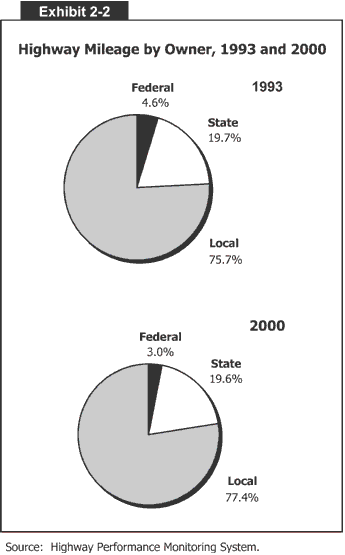
System CharacteristicsHighways and bridges are typically classified by either ownership or purpose, a distinction used in previous editions of the Conditions and Performance Report. Ownership can be determined by which jurisdiction has primary responsibility over a particular structure, while purpose and level of service are identified by the structure’s function. This chapter presents highway miles by jurisdiction and system and use characteristics by functional classification. It also adds a new dimension by examining the deployment of Intelligent Transportation Systems on highways and bridges. Highways and Bridges by OwnershipOwnership is largely split among the Federal, State, and local governments. Roads and bridges owned by these governments are considered “public,” while structures owned privately are commonly considered “nonpublic.” States own almost 20 percent of the Nation’s road system. The Federal Government has control over about 3 percent of the network, primarily in National parks and forests and on Indian reservations. Over 77 percent of American roads are locally owned, although some intergovernmental agreements may authorize States to construct and maintain locally-owned highways. About 1,050 counties in the United States have at least 1 mile of public roads owned by the Federal Government. Most of these counties are in the Western United States. Apache County, Arizona, has the highest percentage of Federal ownership (80 percent), followed by California’s Siskiyou County and Montana’s Lincoln County (70 percent each). As Exhibit 2-2 demonstrates, the share of locallyowned roads has grown steadily over the past decade. The share of local public road mileage increased from 75.7 to 77.4 percent between 1993 and 2000. During that same period, the share of State-owned public road mileage declined slightly, from 19.7 to 19.6 percent. The most dramatic change has been the decline in Federally-owned public road mileage. Between 1993 and 2000, the share of Federal road mileage plummeted from 4.6 to 3.0 percent. This is not a new trend. Federal road mileage reached a peak in 1984, when 7 percent of all public roads were owned by the Federal Government, and has steadily decreased over the past two decades. Much of the change has occurred as Federal land management agencies reclassified some of their mileage from public to non-public status. Another trend is the increase in urban highway mileage. This is described in Exhibit 2-3, which shows that mileage in small urban areas grew by an average annual rate of 1 percent between 1993 and 2000. In larger urbanized areas with at least 50,000 residents, the growth rate was slightly smaller.
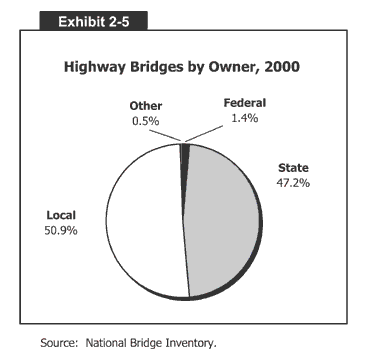
Exhibits 2-4 and 2-5 describe highway bridges by owner. Most bridges in the United States are owned by State or local governments. Approximately 50.9 percent of all highway bridges are owned by counties and municipalities. A slightly smaller amount of all highway bridges, about 47.2 percent, are owned by State agencies. Only 1.4 percent of all bridges are owned by Federal agencies, mostly within the Department of the Interior, and 0.5 percent are owned privately or by other entities.
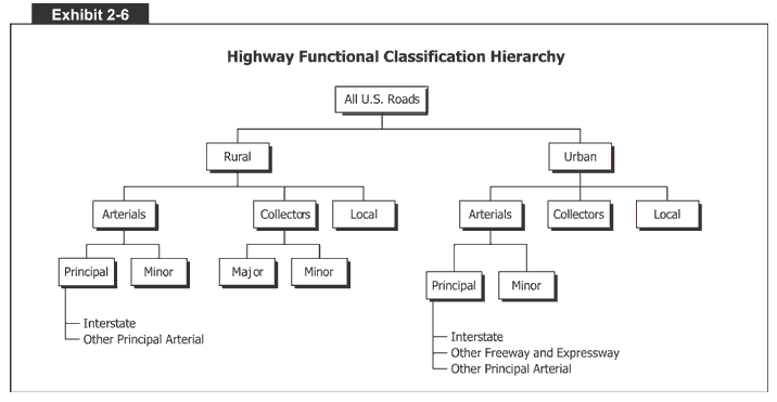
Highways and Bridges by PurposeAnother way to classify roads is by purpose, which is commonly measured by functional classification. The HFCS is the basic organization used for most of this report. Exhibit 2-6 describes the hierarchy of the HFCS. Arterials provide the highest level of mobility, at the highest speed, for long and uninterrupted travel. Arterials typically have higher design standards than other roads. They often include multiple lanes and have some degree of access control. The rural arterial network provides interstate and intercounty service so that all developed areas are within a reasonable distance of an arterial highway. This network is broken down into principal and minor routes, of which principal roads are more significant. Virtually all urban areas with more than 50,000 people, and most urban areas with more than 25,000 people, are connected by rural principal arterial highways. These are typically interrupted only because of unusual geographic or traffic conditions (for example, connections to international borders, coastal cities, waterports, and airports). The rural principal arterial network is divided into two subsystems, Interstate highways and other principal arterials. In 2000, the rural principal arterial system accounted for about 3.3 percent of total miles in the United States. This small portion of highways carried 47.0 percent of rural travel and 18.8 percent of total travel in the United States. The other element of the rural arterial system, minor arterials, represented 3.5 percent of total U.S. miles. Minor arterials carried 15.7 percent of rural travel and 6.2 percent of total travel in the United States. Similarly, in urban areas, the arterial system is divided into principal and minor arterials. The urban principal arterial system is the most important group; it includes Interstate highways, other freeways and expressways, and other principal arterials. The urban principal arterial system serves major metropolitan centers, corridors with the highest traffic volume, and those with the longest trip lengths. It carries most trips entering and leaving metropolitan areas, and provides continuity for all rural arterials that intercept urban boundaries. In 2000, the urban principal arterial system accounted for 1.8 percent of total miles in the United States; however, this network carried 58.4 percent of urban travel and 35.5 percent of total travel in the United States. Urban minor arterial roads provide service for trips of moderate length and at a lower level of mobility. They connect with urban principal arterial roads and collector routes. In 2000, the urban minor arterial network represented 2.3 percent of total U.S. mileage. This system carried 19.3 percent of urban travel and 11.7 percent of total travel in the United States. Collectors provide a lower degree of mobility than arterials. They are designed for travel at lower speeds and for shorter distances. For the most part, collectors are two-lane roads that collect and distribute travel from the arterial system. The rural collector system is stratified into two subsystems: major and minor collectors. Major collectors serve larger towns not accessed by higher order roads, and important industrial or agricultural centers that generate significant traffic but are not served by arterials. Rural major collectors accounted for 11 percent of total U.S. miles in 2000. They carried 19.2 percent of rural traffic and 7.6 percent of total travel in the United States. Rural minor collectors are typically spaced at intervals, consistent with population density, to collect traffic from local roads and to insure that all small urban areas are served by a collector road. The rural minor collector system accounted for 6.9 percent of total U.S. mileage in 2000. These roads carried 5.3 percent of rural travel and 2.1 percent of total travel in the United States. In urban areas, the collector system provides traffic circulation within residential neighborhoods and commercial and industrial areas. Unlike arterials, collector roads may penetrate residential communities, distributing traffic from the arterials to the ultimate destination for many motorists. Urban collectors also channel traffic from local streets onto the arterial system. In 2000, the urban collector network accounted for 2.2 percent of U.S. road mileage. It carried 8.1 percent of urban travel and 4.9 percent of total U.S. travel. Local roads represent the largest element in the American public road network in terms of mileage. For rural and urban areas, all public road mileage below the collector system is considered local. Local roads provide basic access between residential and commercial properties, connecting with higher order highways. In 2000, rural local roads represented 53.5 percent of total U.S. road mileage. Local roads carried only 11.1 percent of rural travel and 4.6 percent of total travel in the United States. Urban local roads, meanwhile, accounted for 15.3 percent of total U.S. road mileage, 14.1 percent of urban travel, and 8.5 percent of total U.S. travel. Exhibit 2-7 summarizes the percentage of highway miles, lane miles, and vehicle-miles traveled by functional system. The share of mileage on rural highways has decreased slightly since 1997, dropping from 78.7 to 78.2 percent, a trend described earlier in Exhibit 2-3. The share of lane-miles on rural highways also decreased slightly, from 77.1 to 76.6 percent; however, the share of vehicle-miles traveled in rural areas actually grew, from 39.1 percent in 1997 to 39.4 percent in 2000.
The share of urban mileage increased slightly between 1997 and 2000, but the share of urban vehicle-miles traveled decreased during that same period. The share of urban highway mileage grew from 21.3 to 21.8 percent, and urban lane mileage increased from 22.9 to 23.4 percent. Although rural mileage is shrinking, travel continues to grow in rural areas. Exhibit 2-8 offers some insight into total public road length in the United States. In 2000, there were over 3.9 million route miles in the United States. About 78.2 percent of this mileage was in rural communities, or 3.1 million route miles. The remaining 21.7 percent of route mileage, or 859,368 miles, was in urban communities. Overall route mileage increased by an average annual rate of about 0.1 percent between 1993 and 2000. Mileage decreased by 0.1 percent in rural America and increased by 1.8 percent in metropolitan communities.
Exhibit 2-9 describes the number of highway lane-miles by functional system. In 2000, there were 8.3 million lane-miles in the United States. Lane-miles have grown at an average annual rate of about 0.2 percent since 1993, mostly in urban areas. In small urban areas with between 5,000 and 50,000 residents, for example, lane mileage grew by about 1.0 percent annually between 1993 and 2000, while rural lane mileage dropped by about 0.1 percent annually during that same period.
Exhibit 2-10 describes the number of highway bridges by functional classification. Of the 587,146 highway bridges in the United States in 2000, 77.6 percent were in rural communities and 22.4 percent were in urban areas. The number of urban bridges—and those on arterial systems—grew steadily from 1996 to 2000. It is presumed that the number of urban bridges grew because of the reclassification of highways (and associated bridges) from a rural to urban designation.
Information presented on bridge composition up to this point has examined ownership and functional classification by “counting” the number of bridges. Examining structures by numbers gives all bridges in the network equal priority. Thus, a small local bridge is counted the same way as either New York’s George Washington Bridge or San Francisco’s Golden Gate Bridge. That is why it may be desirable to consider the size of the structure, which is done using bridge deck area. Exhibit 2-11 shows that despite the higher percentage of bridges in rural areas, more deck area is actually in urban communities (52.4 percent). Urban bridges tend to be larger and longer than rural bridges.
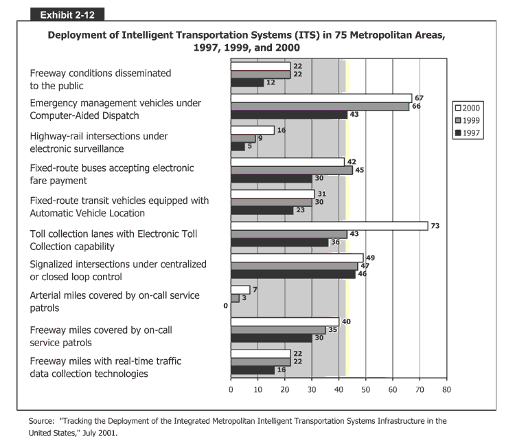
Intelligent Transportation System CharacteristicsAll of the previous exhibits represent a traditional look at the highway system—its mileage, ownership, functional classification, and use. This edition of the C&P report introduces a new measurement: the extent of ITS on the highway network. ITS use advanced technology to improve highway safety and efficiency. The deployment of ITS for national security, operations, and freight management is described more fully in subsequent chapters. Exhibit 2-12 describes the deployment of ITS devices in 75 metropolitan regions, based on a survey by the FHWA Intelligent Transportation Systems Joint Program Office. More regions are using electronic tolling than any other ITS device (73 percent in 2000), followed by computer-aided emergency management vehicles (67 percent). While Intelligent Transportation Systems continue to grow in acceptance and use, the number of arterial miles covered by on-call service patrols remains low at 7 percent in 2000. Use CharacteristicsThis section describes highway infrastructure use, which is typically defined by vehicle miles traveled (VMT). During the 1990s, Americans traveled at record levels, a phenomenon prompted by the booming economy, population growth, and other socioeconomic factors. VMT grew by an average annual rate of 2.7 percent between 1993 and 2000, and by the end of that period, Americans were traveling more than 2.7 trillion vehicle miles annually. About 1.1 trillion miles were on rural highways, and about 1.7 trillion were on urban roads. Exhibit 2-13 describes these statistics.
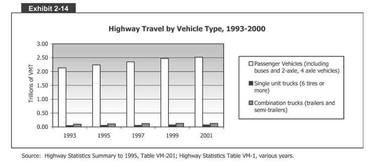
While highway mileage is mostly rural, a majority of highway travel (61 percent) occurred in urban areas in 2000. Since 1997, however, rural travel has grown at a faster average annual rate (2.8 percent) than urban travel (2.6 percent). This is a change since the last C&P report, when urban travel growth rates were higher over the preceding decade. Exhibits 2-14 and 2-15 expand on the information in Exhibit 2-13. They describe highway travel by functional classification and vehicle type. Three types of vehicles are identified: passenger vehicles (PV), including buses and 2-axle, 4-tire models; single-unit trucks (SU) having 6 or more tires; and combination trucks (Combo), including trailers and semi-trailers. As Exhibits 2-14 and 2-15 show, travel grew the fastest on rural and urban interstates, particularly among combination trucks. Between 1993 and 2000, for example, combination truck traffic grew by 4.4 percent on rural interstates and 5.5 per year on urban interstates. Overall, passenger vehicle travel grew by an average annual rate of 2.4 percent between 1993 and 2002. Single-unit truck travel grew by 3.2 percent per year, and combination truck travel grew by 3.9 percent per year.
|
||||||||||||||||||||||||||||||||||||||||||||||||||||||||||||||||||||||||||||||||||||||||||||||||||||||||||||||||||||||||||||||||||||||||||||||||||||||||||||||||||||||||||||||||||||||||||||||||||||||||||||||||||||||||||||||||||||||||||||||||||||||||||||||||||||||||||||||||||||||||||||||||||||||||||||||||||||||||||||||||||||||||||||||||||||||||||||||||||||||||||||||||||||||||||||||||||||||||||||||||||||||||||||||||||||||||||||||||||||||||||||||||||||||||||||||||||||||||||||||||||||||||||||||||||||||||||||||||||||||||||||||||||||||||||||||||||||||||||||||||||||||||||||||||||||||||||||||||||||||||||||||||||||||||||||||||||||||||||||||||||||||||||||||||||||||||||||||||||||||||||||||||||||||||||||||||||||||||||||||||||||||||||||||||||||||||||||||||||||||||||||||||||||||||||||||||||||||||||||||||||||||||||||||||||||||||||||||||||||||||||||||||||||||||||||||||||||||||||||||||||||||||||||||||||||||||||||||||||||||||||||||||||||||||||||||||||||||||||||||||||||||||||||||||||||||||||||||||||||||
| Back |