U.S. Department of Transportation
Federal Highway Administration
1200 New Jersey Avenue, SE
Washington, DC 20590
202-366-4000
FHWA Resource Center
Click here for the PDF Version of the Environmental Quarterly
To view PDF files, you need the Acrobat® Reader®
October 2011
INSIDE
• Introduction: The EQ ‘Disaster Issue’
• Emergency Response – Florida
• ND’s Proactive Response to Emergencies & Disasters
• Collaboration Success for the Crowne Point Bridge Replacement Project
• How Can You Prepare for the Unexpected?
• National Environmental Policy Act Procedures
• ERFO/Refuge Roads Program Use
• Environmental Calendar
LETTER FROM THE EDITOR
Dear Environmental Colleague,
As floods, tornadoes, wildfires and earthquakes during the past several months have demonstrated, natural and accidental emergencies strike without warning–endangering not only our Nation’s transportation infrastructure, but also our fragile environment. This special issue of the Environmental Quarterly focuses on the balanced coordination of emergency response and recovery efforts with the consideration of a host of environmental concerns. Drawing on first-hand experiences with responding to emergency events, our contributors share a variety of perspectives in the following series of articles. We hope that you will find this issue both timely and thought-provoking.
As always, if you have stories you’d like to contribute or story ideas for this newsletter, let us know.
Sincerely,
Lamar Smith
Environment Technical Service Team Leader & Editor–in-Chief
Phone: (720) 963-3210
E-mail: lamar.smith@dot.gov
INTRODUCTION: THE EQ ‘DISASTER ISSUE’
by Keith Lynch, FHWA Director of Program Development

Photo: Keith Lynch in front of Superdome in New Orleans after Hurricane Katrina.
While most of us at the Federal Highway Administration (FHWA) are grinding away at the daily business of delivering the Federal-aid program, there is a tiny corner of the agency that stands ready to race into action. This part of the agency is not focused on the long-term benefits or 20-year horizons, nor is it focused on the strategic goals or the reauthorization schedule. It is concerned with immediate response and recovery in the face of disaster.
When disaster strikes, DOT Order 1900.9 requires that the FHWA and others be on their feet allowing action to immediately spring forward in many directions. The FHWA Emergency Coordinator Network and the Crisis Management Center (CMC) are immediately collecting, analyzing, and vetting information about the emergency and about the condition of our damaged or threatened highway network. The people who staff these organizations are the eyes and ears of the FHWA. The Emergency Coordinators are the vital conduit, supplying data and information to the CMC so that leadership all the way to the White House may make critical, perhaps life-saving decisions with the most accurate information available.
Other FHWA personnel temporarily shed their typical highway duties and transform, along with others in the U.S. Department of Transportation (USDOT), into what is known as the U.S.DOT Emergency Response Team. The multi-modal Emergency Support Function-1 Team (ESF-1) is trained and ready, and is often called into action in the dead of night. The members head straight into the disaster – knowing not where they will sleep or when they will return. Their charge is to support the Federal Emergency Management Agency (FEMA) in response to hurricanes, earthquakes, a tsunami, a terrorist attack, or whatever else has come down the road unexpectedly. Instantaneously, theESF-1 begins supplying the FEMA with infrastructure damage assessments, ships, airspace management reports, pipeline data, evacuation planning, and anything else necessary to assist citizens suffering the blow of the disaster.
And, even as our fellow highwayman surge into emergency response mode, still others launch into deliberate action on the road to recovering our highways’ wholeness. Within hours of the event, expeditious but deliberate negotiations begin between FHWA Division Office, HQ, and State departments of transportation (DOTs) in deciding how best to repair the potentially catastrophic damage. They “break the glass” on the Emergency Relief Program funds, and slash through miles of red tape to help deliver projects in months or weeks that could otherwise take years. The FHWA offices work fervently together to replace what was lost, and to pull the stifled citizenry out of stranded isolation and enable regular deliveries, daily commutes, and shopping trips to get back on track.
Emergency support teams and activities constitute an important part of the FHWA that focuses on helping search and rescue teams get to collapsed buildings and helping get food to hungry families struck by disaster. This is the part of the FHWA that understands the painful impacts of a fractured transportation system and the immediate need to address it. This part of the FHWA keenly knows how to quickly erect structures and build roadways to reconnect people to life-sustaining services, provisions, and resources. This part of the FHWA bands together in an instant to help heal the wounds of crisis, and restore mobility to a damaged community.
You can learn more about the Operations Division of the U.S. DOT’s Office of Intelligence, Security and Emergency Response (S-60) at the Department of Transportation’s web site.
Keith Lynch served as the Region III - Regional Emergency Transportation Representative (RETREP) from 2003 to 2010, and has been an ESF-1 Cadre member since 2001. Keith has led many Regional Resource Coordination Center and Joint Field Office operations, and participated in a great many disaster response operations including Hurricanes Katrina, Rita, Isabel, Charley, Ike, and many others
EMERGENCY RESPONSEE – FLORIDA ACTION
by Cathy Kendall and Nahir DeTizio, FHWA Florida Division Office
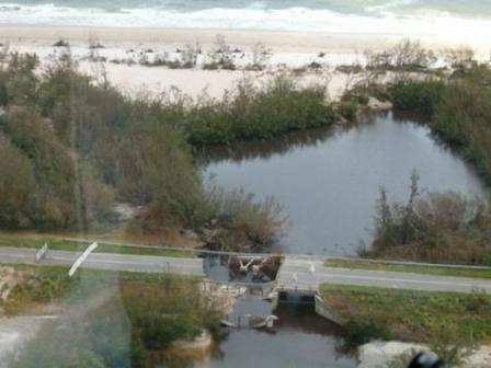
Photo: SR A1A at Little Mud Creek in St. Lucie County, FL, 2004.
Between 2004 and 2005, Florida was hit by eight hurricanes and several tropical storms, which caused severe damage to not only homes and businesses, but also our Nation’s roadways. Getting affected roadways back to a functioning condition quickly is critical for emergency access, as well as safety for the residents, visitors, workers and service providers. With thousands of emergency relief (ER) projects initiated during this time period, with damages totaling more than $1.2 billion in eligible emergency relief expenses, the FHWA Florida Division Office had to overcome many challenges in order to get the ER projects completed as quickly as possible, while still ensuring that the projects met the FHWAs regulations, and were free of waste, fraud, and abuse of America’s tax dollars.
Some of the issues the FHWA Florida Division Office staff experienced with ER projects were related to the class of action for the environmental process. Emergency repairs (as defined at 23 CFR 668.103) meet the criteria for categorical exclusions (per 23 CFR 771.117) and normally do not require any further National Environmental Policy Act (NEPA) approvals (per 23 CFR 668.113(3). However, some ER projects in sensitive locations--particularly those that include permanent repair or betterment—could have additional impacts that would require a higher-level of environmental analysis and coordination.
The 2004 emergency repair project on Indian River Drive, a local road in St. Lucie County, for example, became quite complex due to damage from two consecutive hurricanes. The project site is close to where both hurricanes made landfall. Additional complications arose from the need to do permanent repair work, the sensitivity of adjacent resources, as well as citizen opposition. This particular project went into litigation, delaying completion of the project until a settlement agreement was reached. The settlement agreement required major environmental studies of water quality, sea grasses, and the impacts of shoreline improvements on these resources. The shoreline treatment for this permanent repair used articulated concrete that allowed vegetation to grow through it, creating a more naturally-looking shoreline. The result was a very successful project in terms of function, aesthetics, and environmental protection, but one that required an additional 5 years of environmental studies, and, of course, a much higher cost than had been originally anticipated. As a result, the division office now requires additional documentation to ensure that the assumed class of action is correct.
Section 7 Emergency consultation compliance was another issue on several past ER projects. When an ER project is located in a critical habitat area, even if the project is simply debris removal, the appropriate resource agencies must be contacted and coordinated with regarding potential impacts. Other issues, such as those related to contracting and eligible expenses, require continual education of State and local workers on the FHWA emergency project requirements, as well as coordination with other Federal agencies such as FEMA, whose requirements may be different from those of the FHWA.
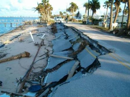
Photo: Indian River Drive in St. Lucie County, FL, 2004.
The FHWA Florida Division Office and the Florida Department of Transportation (FDOT) staffs had to learn many lessons the hard way during and after those years in which hurricanes seemed to have Florida as their most favored destination. Many improvements to the program have been initiated that will help in future emergency events, and in fact, they have already been helpful in more recent hurricane events, as indicated below. Many, if not most, of these improvements are things that can be done prior to a disaster event to ensure that those doing this work are adequately trained in the emergency project requirements, have the necessary contacts and resources for quick access prior to the event, and have knowledge of the both the critical resources in a particular area that may be affected and knowledge about the likely impacts of an approaching storm. The following items are things that the division office and the FDOT have done in advance to ensure a better response to future disasters:
• Emergency Support Function-1 (ESF-1) Team - The division has a team of volunteer staff who are involved in all hazard events with the State. Our ESF-1 Team works with State ESF teams, as well as the Federal Evacuation Liaison Team, which allows us to maintain situational awareness on all hazards incidents, evacuation routes, and one-way plans to assist in a coordinated response to disasters.
• Division Website and Guidance – The Florida Division Office has provided supplemental guidance to the updated official ER Manual November 2009 guidance from HQ. Online training for emergency projects process has also been developed by the division.
• FDOT Website and Guidance – The FDOT has a “Hurricane Events” section on their website, which provides guidance on hurricane recovery, contact information for various agencies, best practices to be incorporated into contracts to reduce takes in areas with listed species, and debris staging guidance (which also includes specific instructions for debris mixed with oil due to the Deepwater Horizon Oil Spill).
• Pre-hurricane event e-mail reminders – The FDOT District Environmental Managers e-mail reminders prior to hurricane landfall to State and local emergency contacts. This e-mail includes: a list of disposal sites, which have been pre-approved by the Florida Department of Environmental Protection; caution for activity near endangered sea turtle nesting areas; instructions for assessments and repairs; and, contact information for permit coordinators and others.
Once a disaster is declared and damage areas are identified, it is now expected that the workers doing emergency repair will have the training and knowledge at their fingertips to comply with the emergency projects requirements. To assist in the assessment of environmental impacts from projects, workers and permit coordinators also have immediate on-line access to all known environmental resources in any given area of the State. This database is part of Florida’s Environmental Screening Tool. This tool was even used by the FEMA in past disasters to identify their debris staging areas. Use of this tool has allowed us to better protect sensitive resources that are located in the disaster area, and has improved our relationship with our resource agency partners.
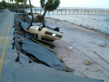
Photo: Impacted vehicle on Indian River Drive in St. Lucie County, FL, 2004.
The division’s Transportation Engineers go to the field as soon as possible following hurricane landfall and begin their assessments of the emergency damage locations and projects. From what has been previously learned, the engineers now have a better understanding of what to look for in their assessments. In addition to the damage assessments, these Transportation Engineers are in frequent contact with the FDOT District Office in the disaster area before, during, and after the event to answer questions and address any issues at the outset.
The Florida Division Office has additional initiatives that are believed to help in the implementation of emergency projects. Some of these initiatives include programmatic agreements with its resource agencies for certain types of projects, and a programmatic agreement for Section 4(f) determination of applicability for the temporary staging of debris in parks. Emergency response and recovery is never easy, but with new strategies and tools to deal with these challenges, the division office is better able to restore the affected roadways for these communities as they attempt to recover from a disaster.
NORTH DAKOTA’S PROACTIVE RESPONSE TO EMERGENCIES & DISASTERS
by Mark Schrader, FHWA North Dakota Division Office and Stephanie M. Stoermer, FHWA Resource Center
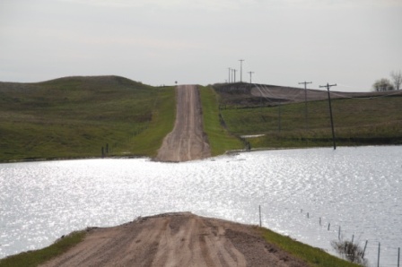
Photo: Ward County Road, 20 miles south of Minot, ND.
Source: FHWA North Dakota Division Office
One of the most important steps Federal, State, and local transportation agencies can take after a disaster is to make sure the transportation infrastructure is safe and sound again, so that affected communities can recover quickly and resume their daily activities. In order to achieve this important step, yet remain consistent with the National Environmental Policy Act (NEPA) and other environmental laws and regulations, it is vital to have measures in place before disasters occur. In this regard, the North Dakota Department of Transportation (NDDOT) and the Federal Highway Administration (FHWA) North Dakota Division Office strive to be both proactive and responsive in developing and implementing response measures before emergency threats arise.
North Dakota's geographic location in the Upper Midwest causes the State to experience some of the widest variation in weather in the United States. Consequently, North Dakota is susceptible to variety of weather-related emergencies and disasters related to floods, blizzards, severe storms, ground saturation, and tornadoes. And over the years, North Dakota certainly has had its share of declared disasters and emergencies.
. 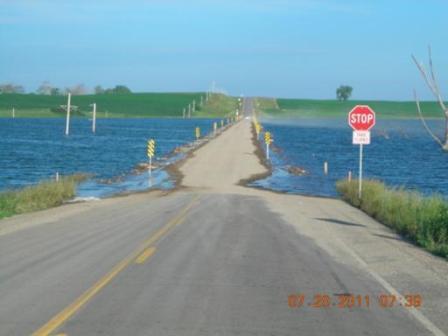
Photo: ND 46 Jamestown, ND.
Source: FHWA North Dakota Division Office.
When the Presidential makes a Major Disaster Declaration long-term Federal recovery programs are set in motion. By comparison, an Emergency Declaration is more limited in scope and without the long-term Federal recovery programs of a Major Disaster Declaration. According to Federal Emergency Management Agency (FEMA) records, since 1957, North Dakota has had 42 declared disasters. Of these 42 declared disasters, 29 were either attributed directly to floods or were flood-related. The FEMA records also indicate that since 1976, North Dakota has had eight Emergency Declarations--three of which were related flooding and were precursors to Major Disaster Declarations.
On May 10, 2011, the President declared another Major Disaster in North Dakota. Although springtime flooding is a relatively common event in the State, the 2011 flood damage throughout North Dakota has been extraordinary in both magnitude and cost. Estimates from the North Dakota National Guard indicate that the total cost of flooding across the State this year could reach up to $1 billion. Additional counties have been added to the initial disaster declaration and it appears likely that this process will continue into the Fall.
Beginning in the early Spring of 2011, flooding episodes and related natural calamities triggered by excessive moisture from snow-melt and heavy Spring rainfall have affected 44 of 53 counties, four reservations, and tens of thousands of people. In north-central North Dakota, the Souris (Mouse) River inundated thousands of homes and businesses as it rose to unprecedented levels, eclipsing records set in 1976 and 1969. Historic flooding along the Missouri River also caused extensive damage and resulted in voluntary evacuations in the south-central part of the State, while in western badlands, extremely saturated ground conditions contributed to the sloughing of hillsides, landslides, and severely undercut roads.
In addition to the flood events along the Souris and Missouri Rivers, the continual, ominous rise of Devils Lake--the largest natural body of water in North Dakota--is a major concern. Devils Lake occupies a basin within a basin. The surrounding basin is that of Red River, but because Devils Lake’s own basin is closed, it must reach a sufficient water level before the water travels elsewhere. Since 1993, Devils Lake has risen an estimated 27 feet, reached record levels several times, and quadrupled in size. According to the U.S. Geological Survey (USGS), by 2000, the rising waters had caused flood damages in excess of $300 million; the latest estimates indicate that the cost has now increased to $1 billion. Over the years, more than 160,000 acres of farmland has been lost, and area roadways are inundated during certain times of the year. Some of these roadways have been abandoned, while others have been raised several times. Although flood control measures are being considered to permanently remedy the situation, until these measures are in place the communities around Devil’s Lake will continue to face the threat of inundated roadways.
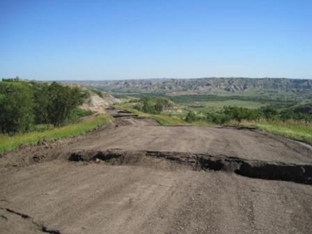
Photo: ND 22 about 14 miles north of Killdeer.
Source: FHWA North Dakota Division Office.
In the northern plains, weather conditions change or deteriorate very quickly. Because of North Dakota's potential for weather-related emergencies and disasters, as well as on-going threats such as the rise of Devils Lake, vigilance and preparedness are critical. As a result, the NDDOT and the FHWA have established measures to ensure that emergency repairs are made quickly and effectively without compromising environmental compliance concerns.
Long-term measures include developing programmatic agreements and providing funded positions at resource agencies. For example, the Emergency Relief Programmatic Agreement between the U.S. Army Corps of Engineers (USACE), the U.S. Fish and Wildlife Service (USFWS), the FHWA, and the NDDOT streamlines the NEPA process for emergency projects. The agreement defines the NEPA requirements for different types of emergency repairs.
The NDDOT also funds positions at two resource agencies to help those agencies prioritize responses to the NDDOT needs. Currently, the NDDOT has one funded position at the USACE and a half-funded position at the USFWS.
The NDDOT and the FHWA took the following actions in connection with the most recent disaster:
• The NDDOT and the FHWA followed 50 CFR 402.05 which allows informal consultation on possible effects to threatened endangered species through alternative procedures where emergency circumstances mandated the need to consult in an expedited manner with formal consultation initiated, as needed, as soon as is practicable after the emergency is under control.
• The NDDOT and FHWA met with the USFWS and North Dakota Game and Fish to discuss potential impacts to slide repair projects in western North Dakota. The NDDOT and the FHWA also met with National Park Service to discuss the environmental impacts associated with a slide repair project that affected the North Unit of the Theodore Roosevelt National Park.
• For Federal Emergency Relief (ER) projects, the NDDOT is consulting with the North Dakota State Historic Preservation Officer (SHPO) on multiple ER projects at once. The NDDOT is also using tribal monitors representing the North Dakota Tribal Consultation Committee during this process.
• The NDDOT proactively conducts archeological surveys in areas that have the potential to be affected by future emergency efforts, regardless of whether or not the emergency efforts are likely to be eligible for Federal funding.
As these examples, the NDDOT and the North Dakota Division Office are keenly aware that natural disasters like as the 2011 floods cannot be averted, and they have taken steps to ensure that appropriate and timely response measures are in place before emergency threats arise. This proactive approach has led to a streamlined and effective process that restores North Dakota’s transportation infrastructure quickly without compromising either safety or environmental compliance.
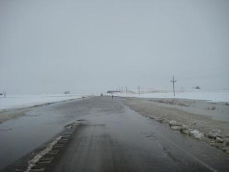
Photo: f F4 site roadway conditions.
Source: FHWA ND Division Office.
COLLABORATION SUCCESS FOR THE CROWN POINT BRIDGE REPLACEMENT PROJECT
by Melissa Toni, FHWA New York Division Office
The Crown Point Bridge spanned over 2,000 feet across Lake Champlain, connecting rural towns in Vermont and New York. Lake Champlain is a very valued and high functioning natural resource for fisheries, and the bridge and an adjacent fort are important historic resources. The Crown Point Bridge, which was originally opened in 1929, was declared structurally-deficient and functionally-obsolete in 2000 and continued to deteriorate rapidly, despite considerable rehabilitation and retrofit work. As a result, a major bridge rehabilitation/replacement study was initiated in 2009. The subsequent bridge inspection reported significant cracking in the concrete piers. Due to a high-potential for bridge failure, the New York State Department of Transportation (NYSDOT) closed the bridge to traffic in October 2009. The detour separated residents from employment, medical services, childcare, farmer’s fields, and family members by 85 miles of alternate routes. The closure was deemed a State-level emergency by both New York and Vermont, but the major bridge replacement project did not qualify for Federal Emergency Relief (ER) funds because a temporary ferry afforded relief to the detoured public.
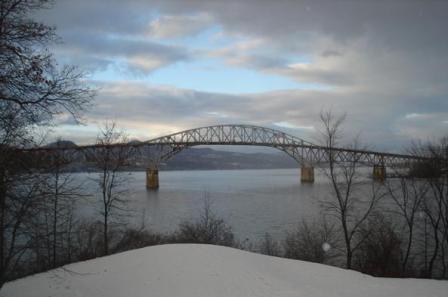
Photo: The Crown Point Bridge over Lake Champlain, before emergency declaration and subsequent demolition.
Source: FHWA New York Division Office
The Vermont Agency of Transportation (VAT) and the NYSDOT opted to pursue bridge demolition followed by replacement, with an anticipated completion in 19 months from the date the bridge was closed, and a temporary ferry operating in the interim.
With respect to permitting the temporary ferry landings and operations, the demolition of the historic bridge, and the construction of a new structure, the two State DOTs and the two FHWA division offices (New York and Vermont) needed to be creative in order to obtain permits very quickly, and complete the work on a design-bid-build basis. Typically, ER-funded projects are afforded automatic expediting of several regulatory processes through programmatic agreements and regional permits. Without the ER status, permits would need to be obtained through traditional processes, but in the same time-frames, and with the same level of flexibility regarding the project’s construction unknowns.
Existing relationships between both the New York and Vermont Division Office staffs and the regulatory agencies have been based on a history of mutual trust, respect, and integrity. These valuable relationships have been developed through years of successfully permitting and construction projects with almost no permit compliance issues. Knowing the good reputations between the groups, the two FHWA division offices understood that the regulatory agencies would process the applications for permits efficiently, but the need for extremely-fast turnaround times was imperative. Additionally, the project would be constructed with design-bid-build principles with a compressed design schedule, potentially increasing the probability of change orders and permit modifications.
Within just weeks of the bridge closure, the FHWA division offices arranged a high-level meeting with the Federal and State regulatory agencies involved in the project, including the U.S. Coast Guard, the U.S. Army Corps of Engineers (USACE), representatives from the State environmental management agencies, water quality agencies, the historic preservation agencies, and the U.S. Fish and Wildlife Service. The purpose of the meeting was to gain a commitment of collaboration during the permitting phase of project development. The regulatory agencies aided the project development process by providing their respective agency standards, such as navigational clearance and acreage thresholds. The permits were issued on time so that the project was bid on time, which was just 5 months from the time that the NYSDOT closed the bridge.
After securing the appropriate permits in May 2010, necessary construction phases were initiated including the demolition of the existing historic bridge structure by blasting, the construction of the temporary ferry landings on the Vermont and New York sides of Lake Champlain, and the construction of the new bridge. One of several commitments that was made to the regulatory agencies was to have an independent, on-site environmental monitor, managed by the VAT, submit regular inspection reports to the water quality agencies and the USACE. The purpose of the monitor was to report field conditions and any permit non-compliance concerns to the NYSDOT inspection team and regulatory agencies.
Several environmental issues related to erosion and sediment control along Lake Champlain, water handling, and concrete curing/dewatering were listed in the monitoring reports. The regulatory agencies expressed major concerns with potential impacts to aquatic resources. Both the FHWA division offices were concerned about potential permit violations and the potential to negatively affect both the natural resources and the project schedule. To help ensure that water quality would be protected and to retain the integrity of the environmental program, the FHWA division offices substantially increased in-house construction and environmental inspections. Engineers and environmental staff also initiated weekly status meetings with the State DOTs and the regulatory agencies to ensure that environmental commitments are realized and to address any potential issues in their infancy. Since the increase in inspections and environmental commitment and coordination meetings, the project has not had any major water quality or natural resource-related issues.
The accelerated bridge opening schedule, which is just one-and-a-half year after the closure (scheduled for December 2011), has been a construction, bidding, and permitting challenge. The respectable relationships with regulatory agencies and the preservation of those relationships have helped keep the project on schedule.
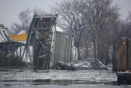
Photo from December 2009, showing the Crown Point Bridge being removed from Lake Champlain by means of blasting, in anticipation of the construction of a replacement structure. Source: FHWA New York Division Office.
HOW CAN YOU PREPARE FOR THE UNEXPECTED?
by Spencer Stevens, FHWA Office of Planning
Prior to SAFETEA-LU, “security” and “safety” were lumped together as one factor for States and metropolitan planning organizations (MPOs) to consider in the planning process. After the security issues posed by the 9/11 terrorist attacks and the natural disaster of hurricane Katrina, SAFETEA-LU broke “security” out as a separate planning factor.
Security means different things to different people. There can be discussions about security that describe the ability of a structure to withstand a terrorist or criminal act, an act of nature, or an accident, or protection of those structures. For the purpose of this article, we are talking about security in a broader sense, describing organizational and structural preparedness to respond to unexpected emergencies.
When the FHWA looks at how State departments of transportation (DOTs) and MPOs are addressing security in the planning process, we find that there is tremendous variation in tactics among them in their security planning roles. It is critical for each MPO to determine its own value-added niche. For example, some MPOs might take on a data gathering and analysis role on behalf of the region's emergency response agencies, while others might take more of a leadership role by organizing meetings or discussions to facilitate better institutional coordination. The security planning requirement is an opportunity for MPOs to define new and non-traditional roles for themselves. There was general agreement that MPOs need to be proactive, rather than waiting for others to approach them, and build support for their security planning mission by demonstrating how their work adds value to the region's immediate emergency response and recovery capacity.
In our work in the Gulf Coast region, we have seen States and MPOs use their modeling capabilities to map the extent of a storm surge and its likely impact on the coastal transportation infrastructure. Many northern region DOTs and MPOs have action plans in place for snow closure of the Interstate system. Washington, D.C., and New York City MPOs and municipal DOTs have coordinated transportation and emergency responder training events to handle mass evacuations. If your region plans for the expected emergencies, it will have the protocols and contacts in place for use when the unexpected occurs.
The FHWA is developing a Security and Emergency Management Planning Tool to help planners and project development specialists know who to contact and how to engage them in planning for and reacting to emergencies. The FHWA also has a resource guide that documents many of the good practices of State DOTs and MPOs that can be shared with interested agencies. The following are a few links to emergency planning resources:
o Highway Infrastructure Security & Emergency Management Professional Capacity Building. See https://www.fhwa.dot.gov/security/emergencymgmt/profcapacitybldg/
o “The Role of the Metropolitan Planning Organization (MPO) In Preparing for Security Incidents and Transportation System Response” by Michael D. Meyer. See www.planning.dot.gov/Documents/Securitypaper.htm
o "Security Considerations in Transportation Planning" from Steven Polzin at CUTR. See http://www.planning.dot.gov/documents/SecurityPapers/SecurityConsiderations_Polzin.htm
o “Volume II: Effective Practices In State Department of Transportation Security Planning;” from the Volpe National Transportation System Center. See http://www.pooledfund.org/documents/TPF-5_085/effective_practices.pdf
o FHWA Emergency Transportation Operations Planning Documents located at http://ops.fhwa.dot.gov/opssecurity/index.htm and at http://ops.fhwa.dot.gov/opssecurity/evac_plan_doc_flyer/index.htm
o The Infrastructure Security Partnership. See www.tisp.org
o ITE site. See www.ite.org/security/index.asp
Additional planning for recovery resources:
o “Conceptualizing and Measuring Resilience: A Key to Disaster Loss Reduction,” by Kathleen Tierney and Michel Bruneau in TR News (May-June 2007). See http://www.trb.org/news/blurb_detail.asp?id=7870
o American Planning Association. “Planning for Post-Disaster Recovery and Reconstruction” (PAS 483/484) 1998. See www.planning.org/bookservice/description.htm?BCODE=P483
o Proceedings of the 1997 Post Hurricane Highway Recovery Workshop. 1997, FHWA Virginia Division. See www.sys.virginia.edu/students/capstone/past/cap1999/11_16_VDOT.doc.
o Volpe System Transportation Center. Long-Term Community Recovery Assessment Tool, 2005. See www.volpe.dot.gov/infosrc/journal/2003/pdfs/chap3.pdf
o “Potential Cost Savings from the Pre-Disaster Mitigation Program,” from the Congressional Budget Office, Publication No. 2926 (September 2007). See http://www.cbo.gov/ftpdocs/86xx/doc8653/09-28-Disaster.pdf
o “Regional Disaster Resilience: A Guide for Developing an Action Plan” developed by The Infrastructure Security Partnership (TISP) June 2006. See http://www.tisp.org/rdr_guide
o Impacts of Climate Change and Variability on Transportation Systems and Infrastructure: Gulf Coast Study, Phase I Draft Report; U.S. Climate Change Science Program Synthesis and Assessment Product 4.7 (Lead Agency: U.S. Department of Transportation; and Coordinating Agency: U.S. Geological Survey, U.S. Department of the Interior) October 2007. See http://www.climatescience.gov/Library/sap/sap4-7/default.php -- While this study focuses on long-term impacts of climate change, it provides an example of scenario-based risk assessment that could be applied to security and disaster management.
o Emergency Relief Manual (Federal-Aid Highways) Interim Update - August 2003, Office of Infrastructure, Office of Program Administration, Federal Highway Administration located at https://www.fhwa.dot.gov/reports/erm/index.cfm
NATIONAL ENVIRONMENTAL POLICY ACT PROCEDURES
by Rod Vaughn, FHWA Resource Center
On May 12, 2010, the Council on Environmental Quality (CEQ) sent out a memorandum reiterating its previous guidance on the National Environmental Policy Act (NEPA) environmental review of proposed emergency response actions.
Over the years, many people have asked the question: What are the requirements for NEPA documentation in emergency situations? Below is a summary of those procedures.
Emergency Situations
In emergency situations, first and foremost, agencies develop their response determining whether there are immediate threats to human health or safety, or immediate threats to valuable natural resources. They must consider whether there is sufficient time to follow normal procedures for environmental review.
The CEQ regulations, at 40 C.F.R. § 1506.11, provide for alternative arrangements for National Environmental Policy Act (NEPA) compliance in emergency situations when the agency proposal has the potential for significant environmental impacts and would require an Environmental Impact Statement.
“Where emergency circumstances make it necessary to take an action with significant environmental impact without observing the provisions of these regulations, the Federal agency taking the action should consult with the Council about alternative arrangements. Agencies and the Council will limit such arrangements to actions necessary to control the immediate impacts of the emergency. Other actions remain subject to NEPA review.”
Taking a further look at those procedures provides insight into minimum NEPA requirements in emergency situations. In summary:
Environmental Assessments in Emergency Situations:
When agencies are considering proposals with less than significant impacts or are uncertain about the significance of impacts, the agency can prepare a concise, focused Environmental Assessment. Agencies must comply with the CEQ NEPA regulation requirements for content, interagency coordination, and public involvement to the extent practicable.
EMERGENCY ACTIONS UNDER THE NATIONAL ENVIRONMENTAL POLICY ACT (NEPA)
According to the memorandum, in the case of an emergency:
1. Do not delay immediate actions necessary to secure lives and safety of citizens or to protect valuable resources. Consult with CEQ as soon as feasible – CEQ will contact agency Federal NEPA contacts in the event you are unable to reach them.
2. Determine if NEPA is triggered and the appropriate level of NEPA analysis:
a. Determine if the proposed action is being taken by a Federal agency (e.g., city or State action does not trigger NEPA; Federal decisions to fund city or State action do trigger NEPA) or is statutorily exempt from NEPA (certain FEMA response actions under the Stafford Act are exempt from NEPA).
b. If the Federal agency proposed emergency response activity is not statutorily exempt from NEPA and the agency has a categorical exclusion (CE) that includes that type of activity, then apply the CE, unless there are extraordinary circumstances that indicate using the CE in this particular case is not appropriate. Agency NEPA personnel should be contacted regarding agency-specific definitions of actions that are “categorically excluded.”
c. If the Federal agency proposed emergency response activity is not statutorily exempt from NEPA and a categorical exclusion is not available, and the potential impacts of the proposed response activity are not expected to be “significant” environmental impacts, then an Environmental Assessment (EA) is appropriate. Prepare a focused, concise EA.
d. If the proposed emergency response activity is not statutorily exempt from NEPA and is expected to have “significant” environmental impacts, the agency should determine whether it is covered by an existing NEPA analysis. (e.g., implementing pre-existing spill response plans).
e. If the proposed emergency response activity is not statutorily exempt from NEPA and is expected to have “significant” environmental impacts and is not already covered by an existing NEPA analysis, then the agency should consult with CEQ to determine whether “alternative arrangements” can take the place of an Environmental Impact Statement.
PREPARING FOCUSED, CONCISE AND TIMELY ENVIRONMENTAL ASSESSMENTS
In those situations where:
• there is no statutory exemption from NEPA requirements;
• there is no categorical exclusion is available, either because the agency has none that cover the activity or there are extraordinary circumstances;
• the proposed recovery/response actions are not covered in an existing NEPA analysis (EA or EIS); and
• the expected environmental impacts of the proposed recovery/response action is not considered to be significant, a concise and focused Environmental Assessment can be prepared in a short time.
The following outline with notations addresses the core elements of an EA as found in 40 CFR 1508.9:
• the need for the proposal,
• alternatives as required by NEPA section 102(2)(E),
• the description of environmental impacts of agency proposed actions and the alternatives, and
• the list of agencies and persons consulted.
Need for the Proposal
The agency should briefly describe information that substantiates the need for the project; incorporate by reference information that is reasonably available to the public.
The agency should briefly describe the existing conditions and the projected future conditions of the area impacted by the project.
Proposed Action and Alternatives
The agency should list and briefly describe its proposed action and any alternatives that meet the project purposes. The agency must use its discretion to ensure the number of reasonable alternatives is reasoned and not arbitrary or capricious. The alternatives should be focused by the need for the proposal. Agency alternatives must meet the need for the proposal.
When there is consensus about the proposed action based on input from interested parties, the agency can consider the proposed action and proceed without consideration of additional alternatives. Otherwise, the agency must develop reasonable alternatives to meet project needs. (NEPA section 102(2)(E)).
Environmental Impacts of the Proposed Action and Alternatives
The agency should describe the environmental impacts of its proposed action and each alternative. The description should provide enough information to support a determination to either prepare an environmental impact statement or a finding of no significant impact.
The agency should focus on whether the action would “significantly” affect the quality of the human environment.
Tailor the length of your discussion to the complexity of the each issue. Focus on those human and natural environment issues where impacts are a concern. Telephone or email discussions with tribal, State and local governments and agencies, and other Federal agencies that operate in the area will help focus those issues.
The agency must discuss the impacts (direct, indirect and cumulative) of each alternative and may (1) discuss those impacts together in a comparative description; or (2) discuss each alternative separately.
The agency should use the approach that will be most effective in the time available.
The agency may contrast the impacts of the proposed action and alternatives with the current condition and expected future condition in the absence of the project. This constitutes consideration of a no-action alternative as well as demonstrating the need for the project.
The agency should incorporate reference data, inventories, other information and analyses relied on. The use of hyperlinks in web-based documents is encouraged. This information must be reasonably available to the public.
The agency should be clear and concise about its conclusions.
Agencies and Persons Consulted
List the agencies and persons consulted.
In conclusion, these procedures should expedite the NEPA process in emergency situations.
ERFO/REFUGE ROADS PROGRAM USE
by Donald Patrick, ERFO/Refuge Roads Program
The Emergency Relief for Federally Owned Roads (ERFO) Program was established in 1977 to assist Federal agencies with the unusually heavy expenses associated with the repair or reconstruction of Federal roads. The ERFO program has permanent annual authorization as part of the $100 million per year distributed by the Secretary of Transportation to the Federal-aid Highway Emergency Relief (ER) Program from the Highway Trust Fund. The roads eligible for the ERFO Program are Forest Highways, Forest Development Roads and Trails, Park Roads and Trails, Parkways, Public Lands Highways, Public Lands Development Roads and Trails, Refuge Roads and Trails, and Indian Reservation Roads.
The Federal Lands Highway (FLH) Division Engineer (DE) determines if a natural disaster or catastrophic failure is eligible for ERFO funding. The FLH DE determination concerning the extraordinary nature of the natural disturbance is not necessary when the President issues a Major Disaster Declaration under the Robert T. Stafford Disaster Relief and Emergency Assistance Act.
FHWA/FLMAs Environmental Challenges
Gulf Island – Climate Changes
Santa Rosa Island, Florida, is a migrating barrier island in the Gulf Islands National Seashore and is served by two park roads on the island. Fort Pickens Road provides access from Pensacola Beach westward towards the Fort Pickens Area, while J. Earle Bowden Way provides access from Pensacola Beach eastward through the Santa Rosa Area and on to Navarre Beach. Both roads were severed by Hurricane Ivan in September 2004, and again by Hurricanes Cindy, Dennis, and Katrina, and Tropical Storm Arlene.
Initial repair plans called for the addition of sand berms, sheet pile, and articulated concrete block to resist future hurricanes and tropical storms. Instead, after much study, those involved implemented a “sacrificial roadway system” that would have a much lower initial cost and fewer impacts on important natural barrier island processes.
In order to mitigate and minimize potential impacts to natural and cultural resources during construction, contractor employees were instructed on the sensitivity of the general environment. Building the roads with this process will allow shoreline processes to proceed relatively unimpeded, achieving a balance between resource protection and public access.
Visitation to the Gulf Island National Seashore, without the two roads, had dropped from 4.9 million visitors per year to 1.7 million. In 2009, both J. Earle Bowden Way and Fort Pickens Road were reopened to public traffic. A major tourist route and link to several communities is finally restored, and designed to better accommodate future storms and repair.
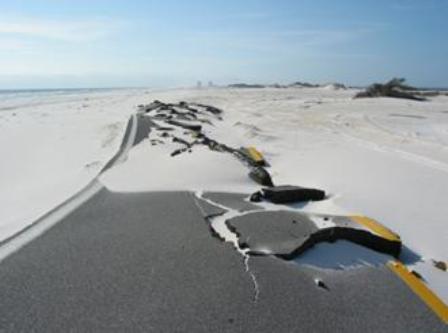
Photo: Fort Pickens Road, Santa Rosa Island, FL. (Before)
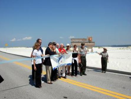
Photo: Fort Pickens Road, Santa Rosa Island, FL. (After)
Devils Lake Roads-Acting-as-Dams: Protecting Resources
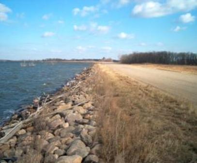
Devils Lake is a closed lake basin located in north central North Dakota. Due to a wet climate cycle, Devils Lake began rising in the 1940s, beginning at approximately 1,400 feet elevation. By 1993, the lake had reached 1,423 feet, and has since risen another 31 feet to 1,454 feet in 2011. This dramatic increase in lake volume translated into a quadrupling in the footprint of the lake. Roads that had been miles away now had water on both sides and were acting as dams without the necessary components requiring clay core and internal drainage components. Failure of these roads would seriously compromise the area transportation network, requiring long detours for local residents. More importantly, several communities would be flooded, endangering lives and displacing residents and businesses.
The goal of the project was to provide a long-term, safe regional transportation network in the St. Michael and Acorn Ridge areas of Devils Lake. This project was unique because the “No Action” alternative had more impacts than the “Action” alternatives. FHWA and the Spirit Lake Nation, Bureau of Indian Affairs, and the North Dakota Department of Transportation partnered to identify a strategy to protect these roads acting as dams and to streamline environmental processes. In addition, Army Corps of Engineers and Bureau of Reclamation were able to provide expertise on dams.
The final design was structured to best utilize available funding by staging the construction in response to future lake rises. The “build as needed” approach responds to funding and environmental stewardship responsibilities by only building what was necessary. The project team prepared the Environmental Assessment and FONSI in only 26 months—an especially impressive timeline given the complexity of the project. In the end, the project was able to produce and begin implementing a design for a system of perimeter dams and roads built-as-dams to protect the transportation network, while also protecting local communities.
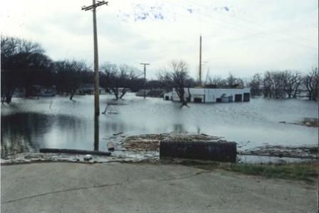
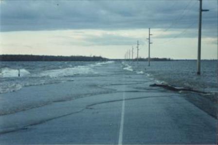
Photo:f Devils Lake, North Dakota.
Photos:f Devils Lake, North Dakota.
What's Going On?
November 2011
Historic Bridge Awareness Month
National Native American Heritage Month
Nov. 6
End of Daylight Saving Time
Nov. 14-17
National Tribal Transportation Conference
Nashville, TN
January 2012
Jan. 4-8
Society for Historical Archaeology Conference
Baltimore, MD
Jan. 22-26
Transportation Research Board 91t Annual Meeting
Washington, DC
April 2012
Apr. 18-22
Society for American Archaeology 77th Annual Meeting
Memphis, TN
June 2012
June 5-7
2nd National Conference on Engineering & Ecology for Fish Passage
University of Amherst, Massachusetts
www.fishpassageconference.com
September 2012
Sept. 9-12
Northeastern Transportation & Wildlife Conference, Hosted by Maine DOT
Location TBD
For additional conferences and events, see https://www.fhwa.dot.gov/hep/calendar.htm
CONTACT INFORMATION:
Federal Highway Administration
Resource Center
Editor-in-Chief
Lamar Smith, Environment Technical Service Team Leader
Phone: (720) 963-3210/Fax: (720) 963-3232
E-mail: lamar.smith@dot.gov
Editorial Board Members:
Melissa Toni, FHWA NY Division
Phone: (518) 431-4125 x 227
E-mail: melissa.toni@dot.gov
Brian Smith, Biology/Water Quality Specialist
Phone: (708) 283-3553/Fax: (708) 283-3501
E-mail: brian.smith@dot.gov
Stephanie Stoermer, Environmental Program Specialist/Archeologist
Phone: (720) 963-3218/Fax: (720) 963-3232
E-mail: stephanie.stoermer@dot.gov
Deborah Suciu-Smith, Environmental Program Specialist
Phone: (717) 221-3785/Fax: (717) 221-3494
E-mail: deborah.suciu.smith@dot.gov
Production Schedule:
Due to our Quarterly publication schedule, all article submissions for future issues are due to the Editor-In-Chief by the 10th of March, June, September, and/or December
Getting the news:
*If you would like to receive this newsletter electronically, please send your email address to: marie.roybal@dot.gov

