U.S. Department of Transportation
Federal Highway Administration
1200 New Jersey Avenue, SE
Washington, DC 20590
202-366-4000
FHWA Resource Center
Click here for the PDF Version of the Environmental Quarterly
To view PDF files, you need the Acrobat® Reader®
INSIDE
• Katiann Wong-Murillo, Environment TST, Retires
• New Online Resource Helps Local Government Deliver Federal Aid-Projects
• Context Sensitive Solutions (CSS) National Dialog, Round 2
• CSS, Complete Streets and Livability: Overlapping Initiatives
• FHWA Traffic Noise Model (TNM) Version 3.0 Development Update
• FHWA's Section 4(f) tutorial is now live!
• Locating Community Data Sources: It’s Not Rocket Science
• Interim Guidance for Implementing MAP-21 Section 1319 “Accelerated Decisionmaking in Environmental Reviews” is Available
• What I Found Most Beneficial During My FHWA Environmental Internship
• Calendar
In January of this year, FHWA and the RC Environment-Realty Team bid a fond farewell and wished great happiness to Katiann Wong-Murillo as she took a giant step into her well-deserved retirement. In the first article of this issue of the EQ you will find a very brief overview of her 34 year career and accomplishments with FHWA. I would like to take this opportunity to share with you what the article didn’t say. I have known Katiann for at least 20 years, as a peer and for the last 4 years as her supervisor. It was always fun and a pleasure to work with her. Everything Katiann did was done with a passion. She is one of the most positive and pleasant people I have known and worked with. Now that she is free of the 9 to 5, we wish her all the best. I hope you enjoy this issue of the newsletter. I have already.
Sincerely,
Lamar Smith
Environment Technical Service Team Leader & Editor–in-Chief
Phone: (720) 963-3210
E-mail: lamar.smith@dot.gov
Katiann Wong-Murillo Retires After 35 Years of Federal Service

Image collage with a photo of Katiann Wong-Murillo and a postcard with the words ‘Greetings from San Francisco.’ (Photos by Deborah Suciu Smith and Stephanie Stoermer.)
Katiann Wong-Murillo, Environmental Program Specialist with the Resource Center Environment Technical Services Team retired January 3, 2013. Her career in federal service spanned 35 years—34 of which were spent with the Federal Highway Administration. Katiann joined FHWA in September 1979.
A Bay Area native, Katiann graduated from George Washington High School in San Francisco. She attended the University of California, Berkley and Thomas Edison State College and holds a B.A., Environmental Studies and a Master of Science in Management. As a member of the FHWA Environmental Justice Team, Katiann was a co-recipient of the 2012 Administrator's Award for Excellence in Teamwork.
During her tenure with FHWA, Katiann wore many hats—both literally and figuratively. In addition to providing outstanding training and technical assistance in NEPA, Environmental Justice, Public Involvement and Cumulative Effects Analysis, Katiann is fondly remembered for her ability to organize conferences and workshops and for always asking the right question at the right time.
Her dedication to both the FHWA and knowledge of the human and natural environment were evident to all who worked with her. However, it was her ever ready smile and sense of humor that was quick, sharp and always appreciated that truly made her a pleasure to work with.
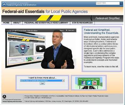
Screenshot of website for Federal-aid Essentials for Local Public Agencies.
New Online Resource Helps Local Government Deliver Federal-Aid Projects
Local public agencies (LPAs)—mostly counties, cities and towns—own and operate the vast majority of the nation’s highway system. The nation’s local roads network comprises about 3 million miles, or nearly 75 percent, of the overall system, and more than half of the bridges. Local public agencies build and maintain the local roads network using a variety of funding sources, including the Federal-aid Highway Program. Every year LPAs administer about $7 billion in Federal-aid projects, which can range from short sidewalks and bike-pedestrian facilities to pavement overlays and bridges.
When LPAs receive Federal-aid funding, they begin a process of working closely with their respective state department of transportation (state DOT) to meet all Federal-aid requirements, such as environmental reviews, civil rights compliance, right-of-way acquisitions, safety, and construction and contract administration. Understanding Federal-aid requirements is critical to the successful delivery of federally funded projects at the local level. Non-compliance can lead to project delays and LPAs not receiving timely Federal-aid reimbursements.
To help LPAs meet their Federal-aid requirements, the Federal Highway Administration (FHWA) recently launch a new information-sharing initiative, called Federal-aid Essentials for Local Public Agencies, that offers an abundance of information about key aspects of the Federal-aid program on a single public website.
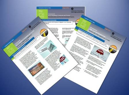
Image showing examples of Federal-aid Essentials for Local Public resource guides.
The Federal-aid Essentials website features a resource library of more than 80 informational videos and related materials. The videos focus on a single topic in the most critical areas of Federal-aid. The videos are relatively short at less than 10 minutes long, professionally narrated in non-technical language, and supported with engaging graphics and animation that give viewers the most essential content. The videos can be viewed in any sequence from any computer or mobile device with Internet access.
When users first enter the Federal-aid Essentials website they will be greeted with a brief introductory video about the Federal-aid Essentials initiative and how to navigate the Web site. From there, users will have access to the resource library via a convenient drop-down menu that presents seven categories of video modules:
• Federal-aid Program Overview.
• Civil Rights.
• Environment.
• Finance.
• Right of Way.
• Product Development.
• Project Construction and Contract Administration.
After choosing a category, a menu of video modules for the specific category appears next to the video viewing screen. Users simply click on the desired video title and the presentation begins. On the same page, users have access to a wealth of companion materials, including a written, printable script of each video, the applicable Code of Federal Regulations, helpful reference information, and links to additional online resources. Another function allows users to give feedback on a particular video, the full resource library and the website itself.
If users have questions about a particular video’s content or about the Federal-aid program in general, they can click on a State Resources button on the main page and gain access to a list of useful information, including individual state and FHWA local office LPA coordinator contacts and web links to state DOTs, state LPA manuals, local technical assistance program (LTAP) centers, and other helpful online resources. A drop-down menu on the main page, titled “I want to know about…,” helps users find information quickly and conveniently about common Federal-aid topics. The site is regularly updated and new features added to meet state DOT and LPA needs and requests.
Since the modules are available anywhere there is Internet access, they can be used in a multitude of settings on any Internet-ready device. They can be shown at meetings, viewed in one’s office or viewed on a job site using a laptop computer or mobile device. A project team can access the videos on a minute’s notice anytime, anywhere for discussion with stakeholders and partners. After viewing the videos, viewers acquire enough knowledge to know what questions to ask their state DOT counterparts, what appropriate technical terminology to use, and how and where to get additional assistance. State DOTs and LPAs also can use the videos to augment training at the local level.
The Federal-aid Essentials website helps LPAs understand their Federal-aid requirements as they pursue better, faster and smarter ways of delivering the Federal-aid program at the local level.
You can read more about the Federal-aid Essentials initiative in FHWA’s Public Roads magazine.
For more information on this initiative, please e-mail the Federal-aid Essentials for Local Public Agencies program.

Image of the CSS National Dialog 2 logo.
Context Sensitive Solutions (CSS) National Dialog, Round 2
By Keith Moore, FHWA Resource Center
FHWA in conjunction with North Carolina State University’s Center for Transportation and the Environment (CTE) have begun the next round of the Context Sensitive Solutions (CSS) National Dialog. The focus of the Dialog is to provide an ongoing exchange of CSS and related transportation industry tools via a series of forums, workshops, and webinars
Similar to the a previous dialog effort during 2008 – 2010 where five regional workshops were held, the latest round will seek to highlight CSS, sustainability, livability, project development, planning, construction, and maintenance. Up to 10 forums, workshops, and webinars are planned over the next two years. Each will provide the latest rulemaking updates and will routinely reference MAP-21 – the most recent major FHWA legislation.
According to CTE, specific goals for the dialog include:
• Introducing CSS principles and practices to a wide array of partner organizations.
• Identifying CSS best practices and presenting those to transportation professionals across the nation.
• Strengthening and broadening the interest in Context Sensitive Solutions.
• Discovering new opportunities for partnerships.
• Bringing new perspectives to planning, designing, building and maintaining transportation facilities.
• Fostering a community of CSS practice and promoting the dissemination of CSS best practice examples.
• Continuing the conversation from the previous National Dialog activities.
There are two ways to participate. The first way is to participate via webinar or attend a workshop. Webinar dates are available from the National Dialog website (listed below). The second way is to host a workshop and invite CSS practitioners to provide case studies and their own stories.
For more information on the current Dialog effort, the final report of the previous effort, and other related activities, visit the National Dialog website..
Selected FHWA staff members are available to provide additional guidance, including:
• Bruce Bender (202) 366-2851
• Keith Harrison (415) 744-2657
• R. Keith Moore (410) 962-0051
• Rod Vaughn (720) 963-3238
CSS, Complete Streets and Livability: Overlapping Initiatives
By Rod Vaughn, FHWA Resource Center
The concept of context sensitive solutions (CSS) has been evolving in the transportation industry since the National Environmental Policy Act of 1969. The CSS concept gained significant momentum in 1998 when the American Association of State Highway and Transportation Officials (AASHTO) and the Federal Highway Administration (FHWA) jointly sponsored the “Thinking Beyond the Pavement” national conference, which generated the first working definition of context sensitive design (CSD) along with a set of 15 principles, including qualities of excellence in transportation design and characteristics of the process contributing to excellence, that were intended to guide the application of CSD in state transportation programs.
Incorporating livability into transportation plan¬ning, programs, and projects is not a new concept. Communities, developers, advocacy groups, businesses, and neighborhood residents have been working for generations to make places more livable through transportation initiatives with varying degrees of support from local, regional, State, and Federal agencies.
These initiatives have used a range of names to describe an overlapping set of objec¬tives and strategies—livability, sustainability, smart growth, walkable communities, new urbanism, healthy neighborhoods, active living, transit-oriented development (TOD), complete streets, and many others.
While advocates for each approach or “brand name” might find differences, most transportation industry practitioners understand the common element among these approaches is that transportation planning is no longer a stand-alone exercise. Increasingly, transportation planning and project development are being more fully integrated with broader community goals, addressing a wider range of needs and leveraging the effectiveness of other programs. The combined timeline for all three concepts (following page) demonstrates the overlap.
CSS, Complete Streets and Livability Timeline
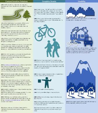
Image showing a CSS, Complete Streets and Livability Timeline that features events from the 1970’s though 2011.

Photo of the afternoon traffic on I-25, Denver, CO. (Photo by Stephanie M. Stoermer.)
FHWA Traffic Noise Model (TNM) Version 3.0 Development Update
By MaryAnn Rondinella, FHWA Resource Center
FHWA seeks stakeholder input on alternative approaches to incorporate new acoustics code inside Computer-Assisted Design (CAD) or Geospatial Information System (GSI) frameworks.
The FHWA Traffic Noise Model (TNM) Version 2.5 is required for use to determine and predict traffic noise levels from Federal highway projects, pursuant to 23 CFR 772.9(a). For several years the FHWA and its partners have been developing an updated version of TNM. The new version is intended to incorporate suggested improvements from expert users of the current FHWA TNM Version 2.5
In 2008, the TNM 3.0 development team, consisting of FHWA and Volpe Center staff, selected the Manifold 8.0 Professional Runtime library to incorporate GIS functionality and for 2D graphics in the FHWA TNM 3.0. In late 2011 the FHWA Office of Chief Counsel, expressed concerns about requiring use of TNM 3.0 due to the presence of Manifold since users would have to purchase a license from a single proprietary source to use software required by regulation. The FHWA would not be able to require use of TNM 3.0 until such a time as other software was deemed consistent with the methodology of TNM per 23 CFR 772.9(a). The FHWA decided to continue development as planned.
During the summer of 2012, the development team discovered that basic functionality that appeared to be present in the Manifold 8.0 Professional Runtime library was not. The FHWA also learned that Manifold had developed a next generation product to replace Manifold. These issues led to reconsideration of the approach to completing TNM. At this point, FHWA decided that the best course of action would be to complete the acoustic code for TNM 3.0 and seek alternative approaches to incorporate the acoustics of TNM 3.0 inside another CAD or GIS framework. To achieve this, the development team will complete development of the acoustic functionality of TNM 3.0 and provide that to FHWA. The FHWA plans to pursue a variety of alternative approaches to complete TNM 3.0 development.
In February, 2013, FHWA issued a broad agency announcement (BAA) to seek stakeholder input on alternative approaches to complete TNM 3.0. The BAA is available at: https://www.fbo.gov/index?s=opportunity&mode=form&id=327f2db47ca10bd795f709790fe8f9fe&tab=core&_cview=1. Please contact the POC listed in the BAA for more information about submission of proposals.
In the meantime, FHWA TNM 2.5 remains acceptable and available for use on all new and updated Federal highway noise analyses. FHWA TNM 2.5 and supporting documentation is available for download free of charge to users at the FHWA Noise Website: https://www.fhwa.dot.gov/environment/noise/traffic_noise_model/
FHWA will also post updates on the TNM 3.0 development on the website.
For more information, contact FHWA Headquarters noise specialists Mark Ferroni mark.ferroni@dot.gov or Adam Alexander adam.alexander@dot.gov.
FHWA’s Section 4(f) Interactive Tutorial is now live!
FHWA’s Section 4(f) tutorial was based on one that Maryland State Highway Administration developed about 10 years ago. This new version was substantially updated to reflect the changes brought about under SAFETEA-LU, the new 23 CFR 774 regulation, and to apply to a national audience. It includes multiple sections on the key concepts of Section 4(f) that can be accessed at your own pace, plus project examples and key terms, all arranged in an easily navigable format. The task force working on the new version included Lamar Smith, Dan Johnson, Diane Mobley, Owen Lindauer, Deborah Suciu-Smith, Tim Haugh, Dave Grachen, Keith Moore, and before he retired, Dave Gamble. Thanks to them all!
Target audiences include State, Federal, tribal, and local transportation agencies, resource agencies, local public agencies, the consultants that support them, and stakeholders who have an interest in the environmental review process for transportation projects funded or requiring approval from FHWA. Other Federal agencies who have expressed an interest include NPS, USFWS, EPA, USFS, and the ACHP.
The new Section 4(f) Interactive Tutorial on the Environmental Toolkit is available online.
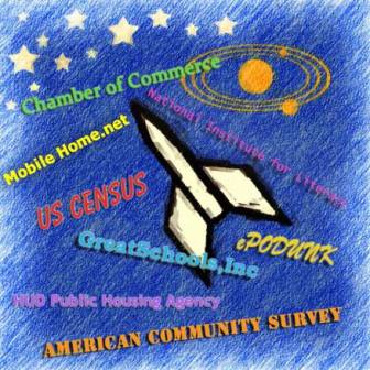
Drawing of a rocket in space surrounded by the phrases Chamber of Commerce; MobileHome.net; US Census; ePODUNK; HUD Public Housing Agency; and American Community Survey.
Locating Community Data Sources: It’s Not Rocket Science
By Anne Morris, Anne Morris and Associates
So you have a project and you are wondering what data sources would help you identify your public, or publics as is often the case. Well, no one source will do all that. But, by pulling together data from a variety of sources, many of them being non-traditional sources but on the web, you can begin to create a composite of your publics. In many instances you may have data overlaps and in others you will have data voids. Some of those voids will be filled in once you go into your project area and talk with community residents. But before you go into your project area, collect as much information as you can from your computer.
A good place to start your data collection is with the US Census and the American Community Survey because they provide a wider array of topics and the ability to drill down to a more detailed level than anything else available. Helpful topics to start with include the following:
• Race and ethnicity – gives Environmental Justice information, creates awareness of cultural differences.
• Income – gives Environmental Justice information, identifies households making less than $10,000.
• Languages spoken at home and how well they speak English – says use of interpreters and translated materials could be appropriate and in which languages.
• Age - provides information relative to ADA considerations, large print use or Braille, need for afternoon or morning meetings, use of signers for the deaf, Section 508 compliant websites.
• Educational attainment – gives insight into those who have not completed high school, low-literacy implications, reading levels, the need for visualizations.
• Travel time to work - provides information relative to what time meetings can be held based on how far away jobs are and how long it takes to get between home and works.
• Time leaving home for work – gives an idea of how many may work 1st shift, 2nd shift, and 3rd shifts and how this affects times when meetings could be held.
• Mode of transportation - identifies personal vehicle dependency, number of people walking, availability of public transit, potential ways to reach the public with low-frequency radio, flyers on buses.
• Zero vehicle households - shows availability of personal transportation and implications as to where meetings could be located so community members without vehicles can attend.
• Number of housing units in structure – provides information about prevalence of mobile homes and multi-family structures.
In addition to the Census and American Community Survey, there are other websites that are more narrowly focused. Two websites such as the National Center for Education Statistics and GreatSchools, Inc. provide supporting information, such as public school data by state, county, and city. Look at elementary schools in your project area because they have smaller attendance boundaries than middle or high schools, can provide more detailed information about students and their families, and have information that is only one or two school years old. More current information can be found within each state’s department of education, or equivalent agency, as they are required to provide the US Department of Education with a yearly “report card” of demographic information on each public school. These websites provide the following information:
• US Department of Education’s National Center for Education Statistics - provides the number of students by race and ethnicity as well as the number of students who are eligible for the Free and Reduced Price Meals programs (low-income) and also provides library locations within the city and county and some demographic information about private schools.
• GreatSchools, Inc. - provides the number of students by race and ethnicity and the number of students who are eligible for the Free and Reduced Price Meals programs (low-income), and comparative information for the state.
There are also websites that provide information on literacy levels and languages spoken, such as the following:
• National Institute for Literacy, The State of Literacy in America: Estimates at the Local, State, and National Levels (1998) – provides the percent of low-literacy individuals 16 years old and over who read at literacy level 1 (approximately fifth grade) for every city over 5,000 and every county and state.
• US Department of Education, Institute of Education Science, National Center for Education Statistics, National Assessment of Adult Literacy, State and County Estimates of Low Literacy (2003) – provides the percent of low-literacy individuals 16 years old and over lacking Basic prose literacy skills for every state and county.
• Modern Language Association, Language Map and Language Map Data Center (2000 and 2005) – provides the top 30 languages spoken by number of speakers in every city, county, and state and provides a breakdown by age of speakers.
The US Department of Housing and Urban Development (HUD) and private mobile home developments provide information on the location and types of these facilities, on websites such as the following:
• HUD Low-Rent Apartment Locations – provides the location of HUD’s low-rent apartments for each state by city, county, zip code and name of property; by contact (management company and phone number); property (address of location and phone number); and type (elderly, family, and disabled).
• HUD Public Housing Agency – provides contact information by state and city for HUD public housing agencies.
• Mobile Home Park Store – provides a nationwide directory of manufactured home communities by state, city, park name, and number of units.
• Mobile Home.net – provides a nationwide directory of manufactured home communities and mobile home communities by state and city, address and management phone number.
In addition to information about Free and Reduced Price Meals, the US Department of Agriculture provides a list of businesses that accept Food Stamps, identifies food deserts, and has compiled a food environmental atlas, as shown below:
• Supplemental Nutrition Assistance Program (SNAP) retailer locations – provides by state, county, city and zip codes, the store name, and address of all businesses that accept Food Stamps;
• Food Deserts – identifies the census tracts in each state that are food deserts and provides population characteristics.
• Food Environmental Atlas – provides, by county, information about the number and percent of the population and the low-income population that have low access to a store, households with no car and low access to a store, as well as 2010 county socioeconomic characteristics.
Often school-related, social, cultural, seasonal, or sporting events and festivals are directed at specific portions of the public or at all portions of the public. Rather than asking the public to come to you, it is often more advantageous to piggyback on planned events that the public will be attending. Consideration should be given to renting a booth and handing out information at an event in or near your project area as a way to engage the public and tell them about your project. Some of the websites that provide date and locational information about scheduled events are ePODUNK, Festivalnet, Festivals.com, and Eventful. Additional good sources of information about local events can be obtained from local Chambers of Commerce, Hispanic Chambers of Commerce, African American Chambers of Commerce, and Asian Chambers of Commerce. These groups will often distribute information about your project to their members.
Racial and ethnic groups can often provide in-roads into communities and introductions to local formal and informal community leaders. Some of these national organizations have local chapters, including the NAACP, National Urban League, 100 Black Men, and National Council of La Raza, and 500 Nations identifies both federal and state recognized tribes across the nations. Even if a tribe is not federally recognized, tribe members are still minority populations. FHWA and the Bureau of Indian Affairs can be helpful in engaging local tribal members.
Faith-based organizations can provide safe meeting locations for some individuals and opportunities to address their congregations. Many also provide local services such as food banks, medical clinics, childcare centers or recreation centers. Some national websites for identifying these faith-based organizations include Black Church Page, Believe.com, Church Angel, Salatomatic (mosques and Islamic schools), Jewish temples and synagogues, Buddhanet (Buddhist temples), Baha’I centers, and Hindu temples. Each website provides contact information.
National stores such as Wal-Mart, Salvation Army, Goodwill, Dollar Tree, Dollar General, Big Lots, and Aldi do extensive location analyses to target low-income customers. Once you identify the location of these stores in or near your project area, meet with the store manager or community coordinator and ask if you can buy goods from their stores in exchange for letting you pass out project information or conduct surveys outside their stores.
Once you define your project area, identify the local media outlets. StreamingRadioGuide.com; Shgresources radio, television, and newspapers; and ABYZ News provide free information and Gebbie Press provides information for a fee. All states have “reading services for the blind” that are free and often reach those that are low literate. You can submit a tape with information about your project to them and they will read it to their audience.
Each of these data sources can provide you with valuable information about the publics within or near your project area. They begin to give you a feel for what the community is like and what you can expect to see when you make your field visits. But be assured that there will be surprises you had not anticipated and your data had not included. That is why you make trips to your project area and talk with members of the community – you have to validate the data you collected. You will find it doesn’t tell you everything you need to know.
Interim Guidance for Implementing MAP-21 - Section 1319 “Accelerated Decisionmaking in Environmental Reviews” is Available
By David Grachen, FHWA Resource Center
The Moving Ahead for Progress in the 21st Century Act (MAP-21) was signed into law by President Obama on July 6, 2012. It provided an array of provisions designed to increase innovation and improve efficiency, effectiveness, and accountability in the planning, design, engineering, construction and financing of transportation projects. Building on FHWA’s “Every Day Counts” initiative, MAP-21 changes will speed up the project delivery process, saving time and money for individuals and businesses, and yield broad benefits nationwide.
The provisions in Section 1319 of MAP-21 provide for the streamlining of the Final Environmental Impact Statement (Final EIS) and Record of Decision (ROD) procedures for Federal Highway Administration (FHWA) and Federal Transit Administration (FTA).
• Section 1319(a) of MAP-21 provides for the preparation of a Final EIS by attaching errata sheets to the Draft EIS if certain conditions are met.
• Section 1319(b) of MAP-21 requires, to the maximum extent practicable, and unless certain conditions exist, that the lead agency will develop a single document that combines the Final EIS and Record of Decision (ROD) into a single document.
On January 14, 2013, the FHWA and FTA issued interim joint guidance on implementing Section 1319 of MAP-21. The guidance can be found on FHWA’s website.
The guidance for Sections 1319(a) and (b) is summarized below:
Section 1319(a) – Final EIS errata sheet approach
The use of errata sheets attached to the Draft EIS in-lieu of a traditional Final EIS is currently allowed under the Council on Environmental Quality (CEQ) regulations implementing NEPA (40 CFR 1503.4(c)). The language in Section 1319(a) reflects the CEQ regulations and addresses circulation and filing of a Final EIS using errata sheets.
Under Section 1319(a), the use of an errata sheet is appropriate when:
• Comments received on a Draft EIS are minor.
• Responses to comments are limited to factual corrections or explanations of why the comments do not warrant further response.
The errata sheets should include, at a minimum, the following information:
• A list of the factual corrections made to the Draft EIS with references to the relevant page numbers in the Draft EIS.
• A list and explanation of why the Draft EIS comments do not warrant further response, citing the sources, authorities, or reasons that support the position of the agency.
• If appropriate, an indication of the specific circumstances that would trigger reappraisal or further response.
In addition, the errata sheets should contain a separate section that includes the following information, as outlined in 23 CFR 771.133 and in section VI(C) of FHWA Technical Advisory T6640.8A:
• Identification of the preferred alternative and a discussion of the reasons why it was selected.
• Final Section 4(f) evaluation, if applicable.
• Findings, including any on wetlands, floodplains, and section 106 effects, as applicable.
• List of mitigation commitments for the preferred alternative.
• Copy or summary of comments received on the DEIS and public hearing and responses.
• Identification of any other findings to be made in compliance with all applicable environmental laws, regulations, Executive Orders, and other related requirements.
When applying Section 1319(a) provisions, FHWA/FTA should include the errata sheets and the information required in an Final EIS in an attachment to the Draft EIS; this documentation must undergo the legal sufficiency review required by 23 CFR 771.125.
Section 1319(b) – Single Final EIS/ROD Document
Section 1319(b) of MAP-21 directs the lead agency, to the maximum extent practicable, to combine the Final EIS and ROD into a single document unless:
• The Final EIS makes substantial changes to the proposed action that are relevant to environmental or safety concerns.
• There are significant new circumstances or information relevant to environmental concerns and that bear on the proposed action or the impacts of the proposed action.
This provision is applicable to all FHWA/FTA proposed projects for which a Final EIS is issued on or after October 1, 2012. Until FHWA and FTA complete a rulemaking including this provision in their NEPA implementing regulations or until final guidance is issued, FHWA Division and Federal Lands Offices and FTA Regional Offices should consult with their respective Headquarters staff prior to implementing the provisions.
The applicable requirements for both a Final EIS and ROD must be met for issuance of a combined Final EIS/ROD document, and all applicable guidance should be followed. These requirements include that:
• The project must be in the fiscally constrained Metropolitan Transportation Plan and Transportation Improvement Program, or from a fiscally constrained Statewide Transportation Planning Program.
• The project must satisfy any air quality conformity requirements in nonattainment and maintenance areas under the Clean Air Act and EPA requirements.
Whether combining the Final EIS and ROD is practicable is a determination specific to the EIS process for a particular proposed project. In using a combined Final EIS/ROD, it will be important to consider possible effects on the timing of required coordination under other laws and the need for any additional documentation.
Through the interagency coordination process, FHWA/FTA should notify agencies as early as possible that they are considering combining the Final EIS and ROD, thereby providing agencies the opportunity to express their views about the use of a combined Final EIS/ROD for the specific proposed action. This will assist the lead Agency to make a determination whether combining the Final EIS/ROD is practicable or whether it is appropriate to issue the documents separately.
Section 1319(b) does not alter the requirements under other environmental laws. At a minimum, a combined Final EIS/ROD must meet the requirements in 23 CFR Part 771 for both a Final EIS and a ROD, except to the extent those requirements conflict with Section 1319 of MAP-21. The format of the Final EIS/ROD is flexible depending on the complexity of the project and other considerations such as accommodating the needs of cooperating and joint lead agencies.
A legal sufficiency review is required for a combined Final EIS/ROD. Projects proposed for processing under the combined Final EIS/ROD provision should include early coordination with the FHWA HQ Office of Project Development and Environmental Review or FTA HQ Office of Planning and Environment, as appropriate. FHWA Division and Federal Lands Offices, and FTA Regional Offices should follow the existing process for submitting Final EISs to their respective Office of Chief Counsel in order to obtain a legal sufficiency review of a proposed combined Final EIS/ROD document.

Photo of Eric Rothermel. (Photo by Deborah Suciu-Smith.)
What I Found Most Beneficial During my FHWA Environmental Internship
By Eric Rothermel, Shippensburg University
Before being hired as an environmental intern at FHWA, I had no previous internship experience. I did not know a lot about FHWA’s role or the various laws and regulations associated with transportation project development. However, throughout the internship I learned a lot from the environmental staff at the Pennsylvania Division. In my opinion the three most beneficial aspects of the internship were:
1. Learning the Laws and Regulations.
2. Learning that we must consider the natural, cultural, and human environments.
3. Working with others in the office, stakeholders, and other agencies to achieve a common goal.
Learning the essential Federal laws and regulations such as, 23 CFR 771, Section 4(f), Section 106 of NHPA, and the Endangered Species Act was difficult, but important for the position. Attending field views, conducting construction site inspections, and reviewing documents allowed me to apply federal laws and regulations. Additionally, my coach supplied me with questions that forced me to dig into the laws and regulations and apply what I know to a situation to come up with the most logical answer.
Learning that the environment is more than just the natural environment was something new to me. Before interning at FHWA, I had no previous exposure to consideration of the human environment, which is a key factor during evaluation of project impacts. This was a big learning curve. My first assignment at FHWA was learning and applying the livability principles. I reviewed long range transportation plans to determine how livability principles were incorporated and to observe what livability means to different regions of the state. This assignment made me realize that livability isn’t a one size fits all approach.
Working with others in the office, various stakeholders, and other agencies to achieve a common goal was a very important lesson, as well. Even if you are the Albert Einstein of environmental issues, if you cannot communicate with people to achieve a goal, your intelligence will get you nowhere. I’ve observed this firsthand during meetings with our state counterpart (PennDOT). At times PennDOT and FHWA may not see eye to eye on certain issues, but through compromise and teamwork, a resolution can be achieved. This is also important when meeting with other federal agencies because of the different missions each federal agency has.
My environmental internship at FHWA has been an eye opening experience and allowed me to apply knowledge that I learned in the classroom and knowledge I learned at FHWA to real life situations. I would recommend this internship to any environmental major looking for experience in learning, reviewing, and applying environmental laws and regulations. Additionally, an internship with FHWA’s Pathways Program can allow a student trainee to enter into the Professional Development Program (PDP) to pursue a permanent position with the agency. Upon graduation, I will be pursuing a position in the PDP program.
Postscript: Eric was accepted into the PDP program and has been assigned to the Colorado Division Office. He will be reporting in June.
What’s Going On?
June 2013
June 23-27
ICOET 7th Biennial Conference. Scottsdale, AZ
http://www.icoet.net/ICOET_2013/
July 2013
July 22-25,
Transportation Research Board (TRB) Committee on Environmental Analysis in Transportation (ADC10) Summer Workshop joint meeting with the TRB Committee on Hydrology, Hydraulics and Water Quality (AFB60). New Brunswick, New Jersey.
http://2013adc10trbsummerworkshop.whindo.com
July 21-23
TRB Historic and Archeological Preservation in Transportation Committee (ADC 50) and Native Issues in Transportation (ABE 80) Joint Summer meeting. Sacramento, California.
http://www.itre.ncsu.edu/ADC50/index.htm
July 28-July 31
TRB Committee on Transportation-Related Noise and Vibration ADC40
Summer Meeting. Santa Fe, New Mexico.
http://www.adc40.org/
CONTACT INFORMATION:
Federal Highway Administration
Resource Center
Editor-in-Chief
Lamar Smith, Environment Technical Service Team Leader
Phone: (720) 963-3210/Fax: (720) 963-3232
Email: lamar.smith@dot.gov
Editorial Board Members:
Brian Smith, Biology/Water Quality Specialist
Phone: (708) 283-3553/Fax: (708) 283-3501
Email: brian.smith@dot.gov
Stephanie Stoermer, Environmental Program Specialist/Archeologist
Phone: (720) 963-3218/Fax: (720) 963-3232 Email: stephanie.stoermer@dot.gov
Deborah Suciu-Smith, Environmental Program Specialist
Phone: (717) 221-3785/Fax: (717) 221-3494 Email: deborah.suciu.smith@dot.gov
Melissa Toni, Environmental Protection Specialist
Phone: (518) 431-8867
Email: melissa.toni@dot.gov
Production Schedule:
Due to our Quarterly publication schedule, all article submissions for future issues are due to the Editor-In-Chief by the 15th of March, June, September, and/or December
Getting the news:
*If you would like to receive this newsletter electronically, please send your email address to: marie.roybal@dot.gov

