


The City of Chesapeake, Virginia, uses negotiated exactions — called “proffers” in Virginia - to fund infrastructure that meets the transportation needs of new development in rapidly growing areas. The City is using proffered right of way and cash contributions from developers of new residential developments along Elbow Road to fund a widening project that addresses the incremental traffic impacts of these developments and prepares the roadway to eventually become a four-lane freeway as the area builds out.
Chesapeake is one of the fastest growing cities in the Hampton Roads region of southeastern Virginia. The city is characterized by urban development in the northern portions adjacent to Norfolk, Portsmouth, and Virginia Beach, with lower density suburban and semi-rural areas to the south. As the Hampton Roads region builds out, Chesapeake is a significant source of greenfield development sites to meet regional demand for housing and employment space. The City uses a form of negotiated exaction called proffer to provide a wide range of infrastructure necessary to meet the needs of rapidly growing areas with minimal existing infrastructure. The City of Chesapeake is recognized within Virginia for its innovative approach to growth management, helping infrastructure keep pace with need.1 The City’s Comprehensive Plan describes the City’s Proffer Policy as a critical tool for growth management.
Figure 1. Chesapeake within the Hampton Roads Region
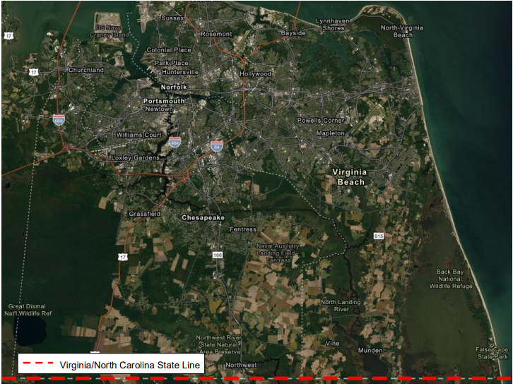
Source: City of Chesapeake Development Maps (https://chesva.maps.arcgis.com/home/webmap/viewer.html?webmap=8452384faaee4565bb54ed1de85f5925)
Proffer is a form of negotiated exaction2 long practiced in Virginia whereby developers extend an offer of value to a jurisdiction in exchange for approval of a rezoning for development. The term proffer means “An act of offering or presenting something for acceptance, or of making a proposal; an offer, a proposition,”3 and the current formal proffer system in Virginia is based on a long-standing historical tradition. Virginia’s proffer system is enabled by State-level conditional zoning, which allows “reasonable conditions governing the use of such property, such conditions being in addition to, or modification of the regulations provided for a particular zoning district or zone by the overall zoning ordinance.”4
Proffer was formally enabled by Virginia law in 1973, originally only for Fairfax County, then extended to a few additional jurisdictions, and finally extended statewide in 1978. The impetus behind State-level enabling legislation was to make proffers legally enforceable. Prior to the law, developers could extend promises without delivering on them.
Proffers are used to meet a wide range of public needs created by a proposed development, including building new roads, improving of existing roads and intersections, and providing public facilities such as schools and libraries. Proffers can take the form of land, cash, or agreement to adhere to architectural or design standards recommended by planning department, or some combination of these. Proffers are commonly extended by developers as part of applications for zoning changes.
Zoning and land use regulations and transportation infrastructure share an important reciprocal relationship that can be leveraged for value capture. The intensity of development allowed by zoning and land use regulations affects demand for transportation infrastructure, and property values, i.e., in the presence of demand, greater intensity of use makes properties more valuable. Similarly, transportation infrastructure affects property values, i.e., in the presence of demand, better served properties are more valua
Up-zoning in the absence of value capture misses an opportunity to ensure that new development pays a fair share of its infrastructure costs. Transportation infrastructure improvements made in the absence of coordinated zoning and land use policies can limit the value of the infrastructure which constrains the amount that value capture can contribute to the infrastructure’s cost.
The City accepts proffers to offset the impacts of new development on the full range of public infrastructure, including streets, water and sewer, school facilities, fire stations, parks, and libraries. The City’s Comprehensive Plan describes the proffer process as follows:
In conjunction with an approval of a rezoning, the City may accept “proffers” from the applicant under the provisions of the conditional zoning process. Proffers are voluntary provisions or donations offered to the City by the rezoning applicant and are aimed at mitigating the impacts of the proposed development. Proffers may include cash funds for public facilities, land for public facilities, assurance of phasing or sequencing of construction, and/or other site-specific elements to ensure that City goals and policies are met. Thus, proffers can be an important method of implementing the Comprehensive Plan and achieving a successful growth management system.5
Developers can offer proffers when submitting proposals for both commercial and residential rezoning; however, proffers for residential and mixed use rezonings with residential components are more closely regulated under State law to deter municipalities from requiring unreasonable proffers. As a result, the City of Chesapeake has established a residential proffer policy to ensure compliance with state law and to protect against legal challenges alleging solicitation of unreasonable proffers. Under this policy, applicants for rezonings with residential components submit a Proffer Statement that does the following:
The proffer statement binds the property owner(s) (including any future owners) to develop the property as described in the approved application. Proffers can take the form of right of way, right-of-way reservation, cash, or other in-kind contribution, and the rezoning approval document stipulates how the proffers are to be delivered (i.e., lump sum deposit to a lock box, deeded right of way reservation), conditions related to proffer delivery (i.e. occupancy permits subject to the proffer being delivered as agreed in the rezoning approval), and circumstances under which a proffer responsibility can be released (i.e. if the City no longer desires a reserved right of way).
Specific to transportation infrastructure, the City’s Master Transportation Plan shows the areas where the City will eventually want to acquire right of way for new and expanded roadways to meet future growth. A developer applying for residential rezoning can use the Master Transportation Plan Map to determine parcels suitable for proffer. The City also has established Level of Service (LOS) standards for the different categories of public infrastructure, including roadways. Developers proposing rezonings that impact LOS can use these standards in conjunction with planning and transportation studies to anticipate proffers that adequately mitigate such impacts. In reviewing the sufficiency of proffers relative to the impacts of a proposed development, the City may accept the results of studies submitted by the developer.
Note that while extending a proffer is a voluntary part of the application process, the requirement to meet infrastructure Level of Service standards is a compulsory part of the development proposal review process. Proffers may not include conditions required by the City as part of the subsequent subdivision or site plan review process. Furthermore, the City may only accept proffers to cover publicly maintained infrastructure, not for privately maintained facilities such as a development’s internal signage or landscaping, and cannot assign responsibility for public facilities to a private entity such as a homeowner’s association. The City Attorney reviews all proffers before a rezoning application is approved to ensure compliance with state law and local policy.
The Elbow Road Widening Phase II and III project is a useful example of how Chesapeake uses this residential proffer policy to acquire right of way and revenues to make roadway improvements necessitated by new development. Elbow Road is located on the west side of Chesapeake in an area designated by the City’s 2035 Land Use Plan as a suburban overlay zone7 which is designed to create an orderly transition in development patterns between urban and rural portions of the city. The approximately three-mile segment between Centerville Turnpike and the Chesapeake/Virginia Beach City line runs through a large undeveloped area8, connecting more developed areas to the west in Chesapeake with those to the east in Virginia Beach. The land north and south of this segment is primarily zoned as agricultural, open space/recreation, and conservation.
Figure 2. Location of Elbow Road within the City of Chesapeake
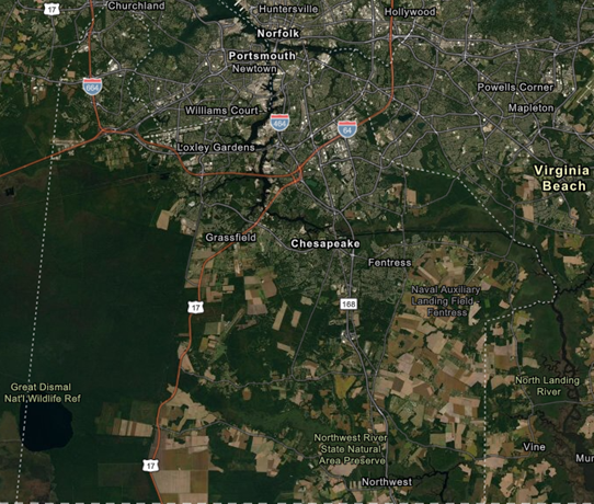
Source: City of Chesapeake Development Maps (https://chesva.maps.arcgis.com/home/webmap/viewer.html?webmap=8452384faaee4565bb54ed1de85f5925)
In 2019, the City of Chesapeake Public Works Department reported that while the roadway currently carried approximately 8,100 vehicles per day, traffic projections for 2040 showed expected daily traffic of 14,000 vehicles. The City of Chesapeake’s 2050 Master Transportation Plan, adopted by the City Council in 2016, shows the eastern segment of Elbow road as a planned new four-lane freeway, and the segment intersecting with the Centerville Turnpike as a new four-lane arterial.
The City developed a roadway widening project designed to improve safety and enhance capacity along this segment of the roadway to meet current and future needs. Phase I of the project realigned two curves, widened travel lanes and shoulders, and relocated selected outfall ditches. Phase II, currently underway, consists of widening Elbow Road to achieve 12-foot travel lanes and appropriate shoulders. Figure 4 and Figure 5 show the two alternatives for Phase II that were presented to citizens at a public meeting hosted by the planning department. The figures illustrate the extent of right-of-way acquisition needed to complete Phases II, as well as the right-of-way necessary for the eventual Phase III expansion which affects 28 parcels.
Three recent residential developments along Elbow Road have proffered rights of way and cash contributions for this project: the Sawyer Property (PLN-REZ-2018-015), Crestfield (PLN-REZ-2018-018), and Dillon Property (PLN-REZ-2017-030) (Figure 3). These developments and associated proffers are outlined below.
Figure 3 . Locations of Sawyer Property, Crestfield, and Dillon Property
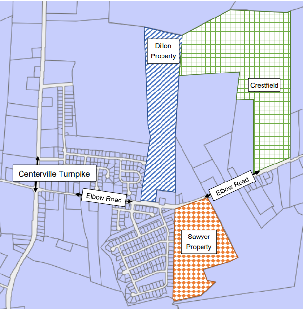
Source: City of Chesapeake Development Map (https://chesva.maps.arcgis.com/home/webmap/viewer.html?webmap=8452384faaee4565bb54ed1de85f5925)
Figure 4. Elbow Road Widening Phase II — Alternative 1
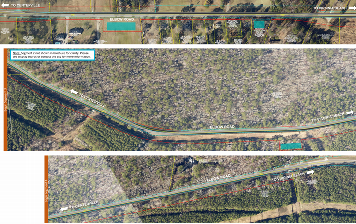 Source: Public meeting notice, City of Chesapeake Planning Department.
Figure 5. Elbow Road Widening Phase II — Alternative 2
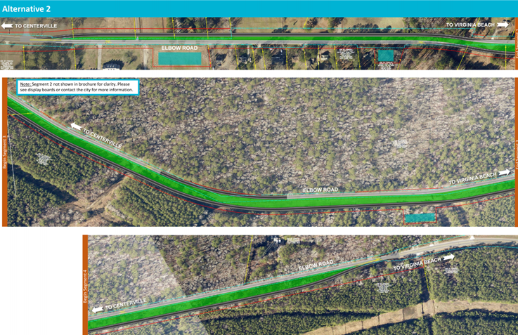
Source: Public meeting notice, City of Chesapeake Planning Department
The applicant for this project sought approval of a conditional zoning reclassification of 51 acres that included parcels zoned both low density residential and agricultural to allow development of 110 lots for single family homes. The applicant offered eight proffers to mitigate impacts on schools, sewers, and roadways, including the following proffers to address impacts to Elbow Road:
Planning Department staff reviewed the rezoning proposal for consistency with existing zoning and the Land Use Plan established in the 2035 Comprehensive Plan, as well as level-of-service impacts to schools, roads and sewers. The staff determined that the proposed development met the City’s established Level of Service standards in all three categories.
The staff report also evaluated the cumulative impacts of the Sawyer project along with other planned and recently completed developments on neighboring parcels. The transportation Level of Service (LOS) analysis noted that the cumulative impacts of the Sawyer project plus the Crestfield development across the street, which had not yet been presented for public hearing when the LOS analysis was performed, would result in an unacceptable decline in LOS during morning and evening peak travel periods. However, as part of the staff report to the planning commission, the Department of Development and Permits, Planning Department, and City Attorney indicated that they accepted the applicant’s proffer as sufficient to mitigate the Sawyer project’s share of impacts to Elbow Road’s LOS. The staff report states:
“The applicant has offered to make improvements along the proposed development’s frontage and for an additional 715 linear feet in an eastward direction, which represents a proportional share of improvements needed for Elbow Road. The majority of traffic generated by the development will travel west toward Centerville Turnpike on the portion of Elbow Road that has been improved. The Department of Development and Permits has no objections to the proposed rezoning and considers the applicant’s contribution a net improvement for the overall roadway.”9
In 2018, Elbow Properties, LLC proposed a zoning reclassification of approximately 120 acres on a site just across the street from the Sawyer development to build 150 single family residential units. The proposal requested a change from neighborhood commercial, agricultural, and low-density residential zoning to a combination of 65 acres of a different low-density residential and 55 acres agricultural zoning. In anticipation of the development’s traffic impact traffic on Elbow Road, the developer offered the following roadway dedication, reservation and improvement proffers:
The zoning approval makes occupancy permits contingent upon the transfer of the offered ROW, specifies procedures for the developer to make the cash payment, specifies how the cash proffer will be allocated and references the state and local regulations governing how the cash proffer may be spent in relation to the development. The approval was also subject to additional non-transportation proffers including architectural and design standards and a per-unit cash proffer to address impacts to school facilities.
In 2018, the Planning Commission approved a proposed rezoning of the 62-acre Dillon Property, on the north side of Elbow Road across from the Sawyer Property and just west of the Crestfield development. The applicant proposed rezoning a 17-acre portion of the property from a mix of agricultural and low density residential (minimum lot size of 15,000 square feet zoning to a residential zoning district with a smaller minimum lot size of 8,000 square feet.
The re-zoning was approved with the following transportation infrastructure proffers:
These proffers are in addition to cash proffers for other public facilities including schools, library, and fire/EMS of approximately $2,546 per unit, as well as architectural and design standards.
Proffers from large new residential developments along Elbow Road have contributed right-of-way for the widening of Elbow Road, constructed portions of the widening, contributed $500,000 cash for the Elbow Road Widening project, and reserved more than 11 acres of right-of-way for the future (planned) Southeast Expressway. In addition, one development proffered nearly $200,000 for public transportation improvements in the area. More generally, proffers are an integral part of the City’s growth management strategy that helps direct growth to areas already served by infrastructure and fund new infrastructure for developments in un-served areas.
Proffers work for the City of Chesapeake because:
1 City of Chesapeake Comprehensive Plan (page 45).
2 Note that under the Uniform Act, negotiated exactions require thorough review when incorporated into a project using Federal Aid.
3 Oxford English Dictionary Online (OED Third Edition, June 2007; most recently modified version published online December 2020, accessed via https://www-oed-com.ezproxy.bpl.org/)
4 “Virginia’s Proffer System and the Proffer Reform Act of 2016”, Edward A. Mullen and Michael A. Banzahf, Richmond Public Interest Law Review (Vol. 20:3, Article 3, page 3).
5 City of Chesapeake Comprehensive Plan page 53-54.
6 Proffered architectural and design standards are typically based on architectural renderings filed with the Planning Department but not necessarily incorporated into the proffer statement.
7 The City's Comprehensive Plan identify distinct urban, suburban, and rural areas within the city, each with alternative or additional development standards that reflect the special features or resources of each area, creating development patterns that promote a distinct sense of community within each subarea as well as an orderly transition from urban land uses in the northern part of the city to rural land uses in the south. (City of Chesapeake Design Guidelines Manual, Chesapeake Zoning Code Article 12, and the City of Chesapeake document “Urban, Suburban and Rural Overlay Districts” located at https://www.cityofchesapeake.net/Assets/documents/business/development/definitiions/Urban_Suburban_Rural_Overlay.pdf).
8 Estimated on the order of 1,600-1,800 acres using the City of Chesapeake’s GIS development map and measuring tool (https://chesva.maps.arcgis.com/home/webmap/viewer.html?webmap=8452384faaee4565bb54ed1de85f5925).
9 Planning Department Staff Report to the Planning Board for Project proposal PLN-REZ-2018-015 Sawyer Property dated January 9, 2019 (https://www.cityofchesapeake.net/Assets/supporting_docs/actions_planning/2019/2019-01-09/pln-rez-2018-015_staff_report.pdf)